
As we continue to debate the merits of subways and light rail here in Toronto, it’s worth noting that across southern Ontario, there’s unprecedented interest in building new major transit projects. In fact, five urban regions – Toronto, Hamilton, Kitchener-Waterloo, Ottawa, and Brampton-Mississauga – are planning or constructing new light rail transit (LRT) lines. Toronto’s Eglinton-Crosstown LRT, the centrepiece of the Transit City LRT plan, and the initial section of Ottawa’s Confederation Line, are both well under construction. The first phase of Waterloo Region’s light rail is funded and construction is set to begin later this year. Meanwhile, projects in Hamilton and Mississauga and Brampton are still unfunded even as construction plans progress, but both LRT plans face local opposition.
In Hamilton, plans for the B-Line light rail transit project have stagnated, largely due to a lack of support by Mayor Bob Bratina and city council. However, the province might still announce funding for the east-west route connecting Hamilton’s downtown with the east end and McMaster University. In Brampton, local opposition threatens a crucial section of the LRT line planned there.
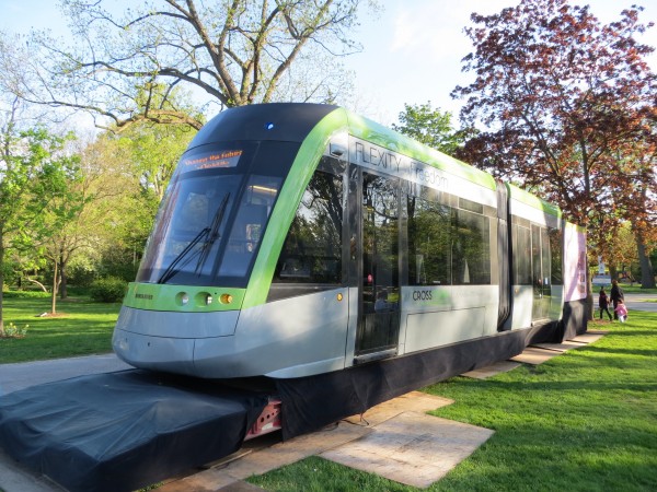
The Hurontario-Main Street LRT Project – named for the linear corridor through Brampton and Mississauga – has gone through several rounds of public meetings. The study team, coordinated by both municipalities, eventually decided that LRT was the preferred option. (Early alternatives studied included bus rapid transit, already implemented on a limited scale by way of limited stop buses operated by both municipalities, and even a subway.) The line, if approved and funded, would connect Downtown Brampton to the north with Port Credit to the south, with a bi-directional loop in Mississauga’s City Centre. It would connect three GO Transit rail lines and serve some of the densest neighbourhoods in the 905 suburbs surrounding Toronto.
Metrolinx has recently stepped in as a partner in the latest phase of the Transit Project Assessment Process, joining the two suburban cities planning the route.
The Hurontario-Main LRT, as proposed, is very similar in design to LRT routes proposed in Toronto’s Transit City plan. light rail vehicles (LRVs) will operate in the median of a busy suburban arterial. Most of Hurontario and Main is six lanes wide; two traffic lanes would be removed to accommodate the LRT tracks. Near Downtown Brampton, LRVs would operate like a streetcar, in mixed traffic.
Outgoing Mississauga mayor Hazel McCallion is a keen supporter of the project, while Brampton’s mayor, Susan Fennell, has been less than enthusiastic. In 2013, Fennell put forward a counter-proposal to extend Brampton Transit-operated Züm buses to Port Credit, but this was later withdrawn.
Unfortunately, the latest design shortens the line slightly on the south end in Mississauga; the line’s southern terminus is now on Hurontario Street at the Port Credit GO Station. This is two blocks short of Lakeshore Road, the commercial heart of the historic and bustling neighbourhood. (An earlier plan had tracks continue south of Lakeshore, to a turn-back at Elizabeth and Port Streets.)
Downtown Brampton, the LRT’s northern terminus, is designated as an anchor “mobility hub” – identified by Metrolinx as a major transit hub where urban growth is to be encouraged. For it’s part, the city continues to encourage high-rise condominium and commercial development in the revitalizing downtown core. It’s the logical terminus of this major transit project.
Opposition in Brampton may threaten the project altogether, or cause the light rail to terminate further south, at Steeles Avenue, or at the Mississauga-Brampton border at Highway 407 (the proposed location of the maintenance yards). Main Street north of Nanwood Drive is lined with old large houses, many built over a century ago; the City of Brampton is in the midst of designating this area as a heritage conservation district. Among the wealthier residents in this neighbourhood is William G. Davis, the former premier of Ontario who famously stopped construction of the controversial Spadina Expressway in 1971.
To address residents’ concerns, plans now call for mixed-traffic operation on Main Street. This would allow full access to driveways and side streets, even if it causes LRVs to wait behind left-turning cars. Consultants are also “exploring catenary-less solutions,” such as batteries, so LRVs could operate off-wire in this section. Crossovers added near Steeles Avenue and near Gage Park allow Main Street to close for parades and the weekly downtown farmers’ market. The loss of street parking on Main Street downtown also has some local business owners concerned, but there is a surplus of parking spots in public off-street garages.
(The necessity of wireless operation seems a little ridiculous to me, as overhead wires are not a problem in other historic districts in Toronto and elsewhere in North America and Europe.)
Still, local light rail supporters are concerned that influential voters may scuttle the completion of the light rail project north to Downtown Brampton; a city council that’s lukewarm towards the project doesn’t help matters. Local residents have set up a website intended to gather support for the project. They are looking for people who support the project to send in comments to demonstrate that there are residents who are in favour, not just a small group of vocal opponents.
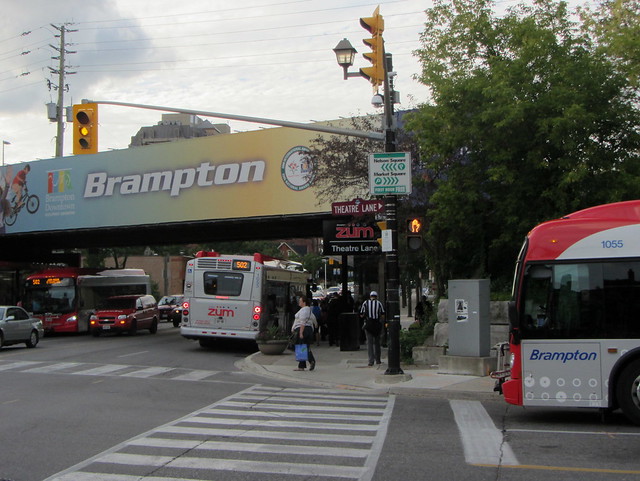 With GO Transit, VIA Rail, and busy bus routes converging here, Downtown Brampton is a busy transit hub.
Downtown is served by seven Brampton Transit routes, including two successful “BRT-lite” Züm bus routes. The GO/VIA station, as well as the busy Queen Street corridor, by far, Brampton Transit’s busiest, all converge here; it’s a potential link connecting Kitchener and Guelph to Mississauga. Not building the LRT direct to Downtown Brampton, only to appease a few local opponents, would limit the utility of the project and undermine the city’s own hopes for its emerging urban centre. City council needs to demonstrate leadership and back the project as planned.

13 comments
This is one of those cases where a short tunnel section is warranted.
“The necessity of wireless operation seems a little ridiculous to me, as overhead wires are not a problem in other historic districts in Toronto and elsewhere in North America and Europe.”
Not quite true. Several cities in France have gone wireless to preserve their historic character over short stretches of line. Nice went with batteries while Bordeaux, Angers and Reims with Alstom ground power supply (APS). There was pressure during the Dublin BX-D city centre link project to consider wireless also. The problem with any off-vehicle solution such as APS or Bombardier Primove is it tends to create a vendor lock-in.
This project is in my backyard, I want to see it completed, and as I think that some sort of compromise solution is justified. Wireless operation? If that’s what it takes to get a yes vote then I’ll all for it. I might even go as far as a short tunnel section, though the presence of the Etobicoke Creek right before the roadway begins to narrow is a cost escalator. But, what I won’t support and hope that none of the decision makers support is a diversion off the corridor. The old Peel Memorial Hospital lands or Kennedy Road (one concession east) has been mentioned as way to avoid the issues in downtown Brampton, but I feel that this would compromise the revitalization efforts that have been really successful. I moved to the area in 1994, and back then it felt unsafe to be in downtown Brampton – especially at night. Today, the area is infinitely more inviting and it would be a shame to undermine that progress.
… But what do I know. I’m just a transit planner…
Much of the objection to the running of the LRT north of Nanwood Drive is not related to the Transit service itself and is not considerate of the needs of transit users. One proposal had the line run over to Kennedy and Steeles then up Kennedy to Highway 7 and back to downtown.
The project consultants are kind enough to look at other options but transit-wise they are just costly additions to the line.
My humble suggestion is this…let the terminal for phase 1 of the LRT at Steeles. Passengers bound for downtown Brampton will still have the ZUM Main 502 “BRT – LITE” and the frequency can be increased since the route isn’t going all the way down to Square One/Mississauga City Centre. And when passengers start complaining and calling for the extension to downtown Brampton, they will have a successful LRT to point to and lots of people asking “why didn’t we do this properly right from the beginning?”
When it comes to transit nothing succeeds like success.
Cheers, Moaz
Couple of things….Susan Fennel is a strong supporter (yes, Council is mixed…but democracy can be messy) and did not suggest replacing this with Züm services…what she suggested that as interim step (while this is being planned and built) start Züm service now between Downtown Brampton and Port Credit as a congestion relieving and ridership building exercise.
That said, not all the people in Brampton are questioning this simply because of the reasons you give. Some of us wonder what the value is to the residents of Brampton and the region as a whole. Why, for instance, is the only true rapid in town being built on a route that barely makes our top 5 busiest transit corridors? Why, with the split now at SQ1 (original plan was a single ride to PC) why should Bramptonians north of Nelson Street support this? Why, with a Metrolinx projection of 2031 ridership of 2900 peak passengers per hour are we building LRT at all…those are numbers easily serviced by BRT services….so the whole GTHA region (possibly the entire province) is paying for another overbuild?
I fully support the LRT and the Main Street alignment to the Brampton GO Train station.
Sorry….the other “Why” I meant to include in my post is why has the province/metrolinx prioritized this over Bramton’s true need which is all day 2 way 7 day per week GO rail service?
Politicians should’t even be allowed to think of Transit planning. They don’t plan longer than 4 years, while transit planning needs to be thought of in decades. The money spent today is an investment in tomorrow, which never goes over well for a politician who’s relevance only lasts till the next election. Take the power of transit planning out of those involved in the popularity contest of politics and leave it with Metrolinx and transit experts.
– Sorry….the other “Why” I meant to include in my post is why has the province/metrolinx prioritized this over Bramton’s true need which is all day 2 way 7 day per week GO rail service? –
GO is currently designed around drive-to stations for people heading to Union Station. Parking lots that hold a couple of thousand spaces for vehicles that sit around all day can’t provide the ridership to support all day service. Brampton needs to boost its local transit service and change its auto-oriented planning. Trying to reroute high quality transit to areas with much less demand is counter-productive.
I agree with Moaz’s idea that if Brampton politicians can’t provide a practical solution, the Province might have to end the service at the Brampton border for the time being.
TOareafan I wish I could believe that Fennel’s proposal for extending the ZUM BRT 502 down to Port Credit LRT was an interim proposal as opposed to a way to object to the LRT…but that’s not the way it came out in May 2013.
If the cities of Brampton and Mississauga were really committed to “Rapid transit” the logical ‘next step’ would be to have one single ‘express’ bus route running from Port Credit to Brampton GO…rather than the current overlapping services. Then they could move forward with the LRT in the future.
Cheers, Moaz
Bombardier is currently developing wireless (in ground) charging technology. Its called Primove http://www.railway-technology.com/projects/bombardier-primove-light-rail-trams-germany/
The importance of developing this corridor cannot be overemphasized as it provides a rapid connection for commuters on the Kitchener GO line direct, rapid access to downtown Mississauga. It is possible to go underground in this section but add about 1B to the price tag.
I’ve always wondered why Mississauga has an east-west busway, but wants a north-south LRT. Bit baffled why one mode in one direction, another mode in another.
Fewer stops on LRT than with local buses. Less flexibility – busses can loop into off-the-main road business districts .
I laughed at the wireless idea. If you look at the LRT planning materials, a lot of the pictures show LRTs magically propelled down the street without wires. Frankly I always thought some downtown toronto streets look horrid with the tangle of overhead wires.
I am probably more skeptical of Metrolinx than of my local politicians. Another arms-length body (Ornge, Ehealth) not accountable to anyone. Not sure how much transit experience the board actually has.
I like the idea of stopping at Steeles, build ridership, and decide later. I would not be adverse to the Kennedy routing. I don’t see much opportunity for growth in the crowded downtown core. Not sure why they didn’t go to Bramalea City Centre instead. If you have to go downtown: Toronto gets a major underground section on Eglinton, why not Brampton. Not sure why it doesn’t extend north to Bovaird or Mayfield. So many questions.
Look ma, no wires
http://lrt-mississauga.brampton.ca/EN/Pages/Welcome.aspx
overhead is careful clipped out of the image