

It looks like we can get ready for our first taste of a revitalized central Waterfront. As reported before, Queen’s Quay West from Spadina to York will be partially closed to car traffic from August 11 – 20 to give us a taste of West 8‘s plan for the Waterfront:
[Quay to the City] will feature activities intended to immerse people in the winning design that affords everyone a taste of Ontario’s popular cottage life without leaving the GTA.
The corporation has gone beyond merely closing off the street, though. Realizing that special programming and events also bring people down to the lake, they will be offering people the chance to canoe around the inner harbour at the bottom of John Quay, take Waterfront walking tours, and take free central Waterfront boat tours. There will also be an “arc de triomphe” bicycle sculpture, elaborate sandcastles, a combined two kilometres of installed lawn and geranium gardens, and a number of other attractions and activities.
Numerous Harbourfront festivals will also overlap with the closure, which might actually make it feel more like the centre of the harbourfront rather than an isolated attraction in an otherwise unfriendly area.
Download the entire program from the Toronto Waterfront Revitalization Corporation’s website here.

3 comments
I just got back from a holiday in France, and was immensley impressed by the “Paris Plages” – where they’ve closed one of the roads along the Seine, brought in sand, a small pool, petanque courts (complete with petanque sets you can borrow), and set up various ammenities including bike rental, a small library, cafes and a post office. An awesome example of reclaiming a roadway for the public’s use, and there were hundreds, if not thousands, down there every night.
I look forward to this trial on Queen’s Quay. They’ve been running the Paris Plages for about 3 years now, and it seems to be bigger and better each year.
Please, please, please tell me that this “transformation” is not included in the actual plan!
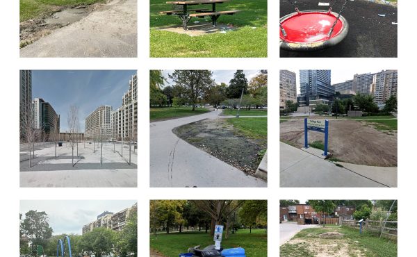
Who thought a 1km long strip of “picnic grass” situated next to a bike path and roadway was something that anyone needs?! People go to the WATERfront for the WATER, not to hang out on a strip of grass surrounded on all sides by pedestrian, bicycle, streetcar, and automobile traffic. If that were the case, we wouldn’t need a redeveloped waterfront, because THIS
would be the most popular picnic spot in the city.
Although this logic would FINALLY explain why the oasis that is the Music Garden was built to overlook a congested marina and an airport and why two more parks designed for lounging are also being built with an airport view, while the best places to enjoy the serenity of the lapping water and views of the forested island have been given to perpetually-Macarena-blaring Island Tour boats.
Do waterfront planners ever visit the places they’re developing plans for, or do they just sit in their offices far, far away drawing pretty pictures of whatever pops in their heads?!
I’m guessing that whoever thought that this design was supposed to afford us “a taste of Ontario’s popular cottage life”, equates “cottaging” with getting a flat tire on the 400 and spending the whole weekend waiting on the side of the road for a tow truck to arrive.
I think Melissa was having a grumpy day on July 28th.