
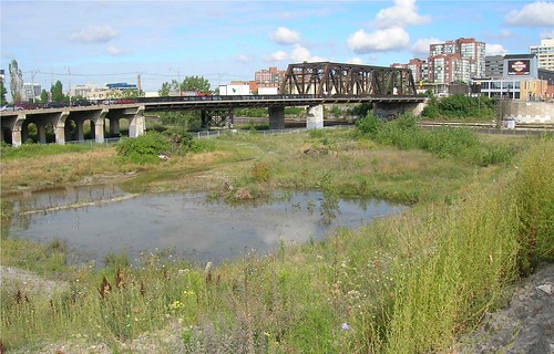
There is going to be a new bridge in town, and Toronto has a rare opportunity to build something great because the Bathurst Street Bridge is about to undergo a major renovation and extension. The familiar truss bridge (the steel-girder section in the above photo) is a listed historical structure so it will remain, but the less dramatic southern half is to be completely replaced with a new design that will accommodate a TTC right of way down Bathurst. Construction is slated to begin in early 2009 with development of the design about to get underway, so it’s urgent the right decisions are made now. City Council has already named the bridge after Sir Isaac Brock and it will be opened within a year or two of the 200th anniversary of his death defending Canada at Queenston Heights.
This is an important project for two reasons.
First, Toronto has the chance to build a real landmark. In the past, Toronto has built great pieces of public infrastructure in a manner this city deserves. Think of the RC Harris Filtration Plant in the Beach, or the Prince Edward Viaduct leaping across the Don Valley. These are iconic bits of city building that have come to define Toronto in our imaginations but have also become part of our lives, as familiar as our own living rooms. More recently, the pedestrian and cycling bridge over the mouth of the Humber River has achieved this status — Spacing even uses a photo of it on our promotional postcards. It is almost impossible to imagine Toronto without any of these structures now.
Great cities will often use bridge building as an excuse to construct something that reflects their collective civic pride — leaps of faith in themselves. Ten years ago London built a pedestrian bridge from the Tate Modern across the Thames to St. Paul’s Cathedral. The “Millennium Bridge,” with its bold and unique design by famed architect Sir Norman Foster (same fellow who did the Leslie L. Dan Pharmacy Building at University and College), has become as familiar and beloved a London landmark as the historic Tower Bridge just down the river.
For Toronto, Bathurst is an ideal location to engage in this kind of heroic city building. The current workaday bridge passes by and over Fort York, the birthplace of the city and one of our most sacred of civic spaces. As I wrote in The Toronto Star back in September, the land underneath the bridge is also the location of the original mouth of Garrison Creek and contains multiple layers of archeological heritage (read the article for more history of the bridge). This location deserves a striking landmark — one that would not only mark and respect this important area, but also create a welcoming and important new link to the waterfront, something Torontonians often express a desire for. Build this bridge well, and suddently Toronto has a grand avenue leading to the lake the likes of which few cities could match.
The second reason the design of this bridge is important is much more practical. The area directly around Fort York and the railway lands is one of Toronto’s newest neighbourhoods and will soon be home to well over 10,000 people. The bridge will be the major element of this new Toronto landscape, visible from both sides and underneath, not just an experienced for those crossing on top of it.
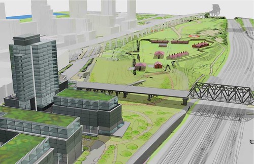
Between Bathurst and Spadina, below the Cityplace condo towers that are quickly going up, a park designed in part by Canadian author Douglas Coupland will soon be under construction. Immediately east of Bathurst, planned Toronto Community Housing Corporation buildings will have the new bridge as their principal view (see below). On the west side, Toronto’s premier historic site, Fort York, has been busy cleaning up and grooming the area underneath the Gardiner and will be installing a new public art piece later this year. Another park, this one named after Toronto activist and secular saint June Callwood, will be built on the site of the recently demolished Molson’s site by the new condo towers that are already supplying the area with life and activity. These areas will be used by the residents that live here, but also by Torontonians from other neighbourhoods either visiting or passing though.
What the bridge looks like from below is equally important. Because the TTC wants to run streetcars along Fort York Blvd and make 90 degree turns at Bathurst, they need the intersection to be level. This could require the lowering of the south end of the bridge, reducing the clearance underneath to just under three meters if the bridge cannot be built thinner with advanced engineering techniques or the ground lowered enough without destroying the invaluable archaeological resources below. On top of this, the bridge will be widened from 20m to 30m to accommodate a dedicated streetcar right of way, increasing the amount of land “underneath” the bridge.
If this happens, the contiguous and lush public spaces on either side of Bathurst will be cut off from each other because the space under the bridge will be rendered an unwelcoming environment. Low concrete tunnels are great for urban explorers and the occasional clandestine dance party, but for the general public they tend to become no-go zones, dark and full of perceived dangers. Keep the space under the bridge high and cathedral-like, as it is now, and the space remains open, sunlit and glorious, one that Torontonians can use for pleasure or for commuting by foot or by bike. For the city of the future, these off-road links through parks and public spaces, downtown and beyond, will become major thoroughfares, supporting the high density Toronto desires. But we have to plan for that now.
The good news is that transit plans, a landmark bridge and a structure that accomodates different modes of of transportation above and below is easily possible with inspired leadership and creative design. Most amazing is that the bridge, combined with the other public space enhancements in the area, has the potential to erase our concerns over what the Gardiner and railways do to our relationship with the waterfront. We’ll be watching progress on this closely over the coming months. Scroll down to see more renderings of area in question.
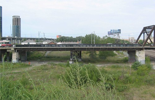


The above three photos illustrate the “cathedral” height of the current bridge. Though not landscaped and often covered with debris and rubbish, the area under the bridge is wide and open and a surprisingly pleasant place to visit (again, see Star article for more description of this experience).
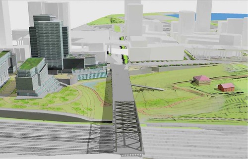

New buildings will be mixed use, with a library and daycare. The middle photo above shows the Bathurst corridor surrounded by new the community.

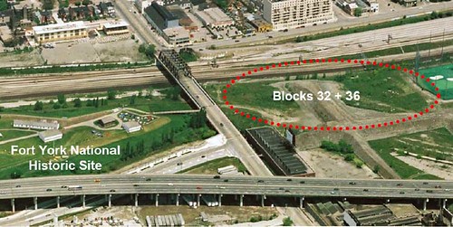
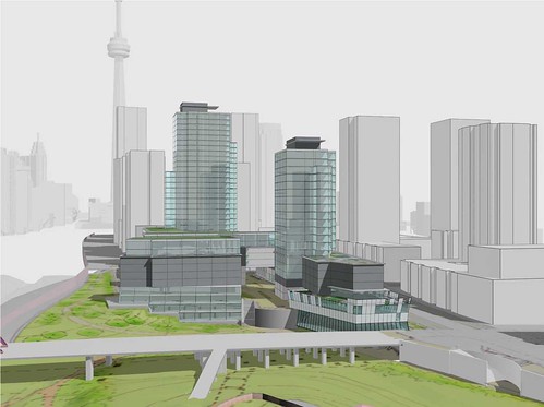
Toronto Community House Corporation buildings will rise close to the Bathurst and Front intersection. Note the small patch of parkland in the above photo to the right of the bridge is also part of the Fort York Historic Site, but is currently scrub land adjacent to the railway tracks. This land will be reunited with the Fort.
Thanks to Stephen Otto for his assistance in putting this piece together. For further background on the bridge rebuild please check his article in the September 2006 edition of Fife and Drum (pdf), the regular publication of the Friends of Fort York.
All photos courtesey of TCHC , prepared by the Centre for Landscape Research at the University of Toronto & du Toit Allsopp Hillier.


42 comments
ARE THEY GOING TO OUST AMSTERDAM BREWERY???
These things are complex.
Unfortunately, no mention of bicycles and our safer passages – there’s a real need for safe north-south travel, aggravated by streetcars and getting to the railtracks/bridges in the first place. Maybe an outer pedestrian way could get added to the side of the old bridge and bikes could take a now sidewalk?
I’ve also been thinking over the last few years of how to boost transit through this area, specifically on the north side of the tracks. There’s a nice way of getting streetcars/transit up from the rail level via the strip of remnant Lands and Gardens Trust on the south side of Front St. to grade level. Ideally, any new construct is allowing for this to happen, as there’s great potential for using the rail corridor for transit to the NW, and getting the transit up to street/Front level eases passage into the core via Front St. Even if we were to divert some of the King or Queen St. transit down along the north side of the Weston tracks to the core, it would begin to speed up the lousy service there. Such concepts are resisted by some politicians and remain unexplored because it would interfere with the Pantalone parkway aka FSE.
I know there’s the Rail Trail too – in the short term this would be good to have here but the higher and better use of the Weston corridor is transit though maybe we could have both.
Too bad – it means we trend towards trans*it.
See the weston community coalition site for an idea to use this corridor for public transit, and much of it was suggested for transit use in the downtown relief line of c. 1985.
I hope that a interpretation building or museum will be put on the east side of the Sir Isaac Brock (Bathurst) Bridge, so that the bridge becomes a canopy over a pathway leading to the fort.
you;d think toronto would get the surrounding condominium developers to pony up some cash for this. Maybe use development as leverage for infrastructure.
but no, toronto likes to whore itself out to condos, for the lowest price.
we all know toronto wont get the bridge it deserves. it will be some lame piece of shit, just like Museum station. and the rom. and the waterfront. and the opera house. and the TTC. and the portlands. and the bike lanes……
why do the condos right next to the most historically significant piece of toronto look like any other condo?
Toronto seriously does not give a shit for any of its history.
See:
1) http://www.youtube.com/watch?v=YBKSwxS7Ko0
2) http://www.thestar.com/article/347600
A few corrections and comments:
Author Douglas Coupland is not designing the Railway Lands West park. He’s collaborating with a real landscape architecture team, same one as Sherbourne Park in the East Bayfront. If you read the article link, only the headline credits Coupland with the commission. Elsewhere it states otherwise.
The Friends of Fort York are hard core advisors to the redevelopment of the lands around the Fort. No one cares more for the history of this area than them. Get involved if you care about what goes up next to the Fort.
The designers for the Bathurst Bridge also did the new ped bridge in Ottawa over the canal. It’s winning awards so hold out hope.
BARAY> The Friends are heavily involved already, and have been on this project for a few years now. Check the Friends of Fort York “Fife and Drum” newsletter I linked to at the end of the post.
Groups like the Friends disprove jt’s comment above, there are loads of people in this city who “care” about history. There is every reason to be hopeful about this project.
The Copeland link I used is old, and didn’t have time to dig for updated stuff — but wanted to include his involvement in the area.
W.K. Lis> Fort York’s planned interpretation centre will be put in on the west side of site, near the new entrance off Fort York Blvd. There’s no room on the east end for the type of structure envisioned. However, a new bridge will certainly have a new east entrance to the Fort included.
The Bathurst Street Bridge should be left exactly as it is. If we work very hard at appreciating our built heritage, we might just deserve it, and Toronto, as it is.
21 Bathurst Street, upon which there is a massive expressway billboard, does not appear in these renderings. That’s the Amsterdam building. What’s the deal on this building?
Wow, excellent post. Deserves a full Spacing article.
As it happens I’m rather knowledgeable about bridge design, having studied years ago under one of the acknowledged experts on the subject and completed a thesis on a bridge design competition.
The quick advice to the ones choosing the design – go for the Three E’s. A structurally Efficient bridge is often also the most Elegant solution, and also the most Economic. There is a funny curve to bridge design, where conservative assumptions lead to more weight, and more weight leads to more structure, which leads to more weight. The result is ungainly. You want to get to the other side of the curve, where intelligent design decisions produce a lighter bridge, whose lower self-weight allows for such elegance.
An example of the three E’s in action:
http://snurl.com/22udv
The streetcar does complicate things, being a heavy point load that moves along the structure, and the sheer planned width of the bridge really makes it more of a blah viaduct and less of a properly proportioned span. Forcing the old truss span to remain also complicates the aesthetic options. These can be difficult challenges — just look at the Bunker Hill Bridge in Boston, which had the right designer (Menn) but was overwhelmed by the width of traffic lanes and ended up looking really awkward up close (despite the lovely profile from a distance):
http://snurl.com/22udu
Being small and funding-poor as far as wealthy nations go, Canada is a terrible environment for good infrastructure design, so there is unfortunately little local talent available for this task. Will the city consider outside designers from Europe or elsewhere, perhaps teamed with a strong local engineer for the actual construction documents? I would recommend talking to Arup, for example, or other firms with strong small-bridge-design portfolios. How is the design selection process being run? Hopefully the city will take an enlightened approach.
NOte – Be wary of just passing this off to an architect — yes, the landscape below requires some input from landscape designers but architects do not really understand bridge construction/design. (The Millenium Bridge was really designed by Arup. Foster likely had some concepts and certainly handled decor, lighting, finishes – but even the great Lord F wouldn’t know a moment connection if it hit him on the noggin.)
My own concept? Do a play on the original truss bridge by placing a new span of trussed construction next to the old one – but utilize modern technology in steel fabrication and 3D design to really warp the hell out of the truss while being ultra efficient. A conservative, clean truss leads to a truss gone wild that rotates and goes all out of plane as it twists across Fort York, beams and girders in all directions. Kind of like a tube of steelwork with the patterns of the Beijing Stadium (and containing a level roadway of course). It would almost look like the south half had collapsed from a higher level – but it would be efficient, elegant, economic and downright beautiful.
Just noticed the above comment about the Ottawa bridge. I hadn’t heard of this before, but found it here:
http://en.wikipedia.org/wiki/Corktown_Footbridge
Very similar in design to the example I gave in my first post. Turns out this design was done by Delcan, a local engineering firm that also did the Humber Bridge. The firm is now part of a massive Dutch group (DHV) and the head office is now in Markham instead of Don Mills + Eglinton, but if they are doing the bridge the project will be in good hands. They know what exactly what they are doing and are by far the best local choice:
http://www.delcan.com/pdfs/delcan_bridge_engineering_brochure.pdf
uSkyscraper> It’s amazing that the Salginatobel Bridge you link to in your first comment (first link) dates to 1930.
uSkyscraper> Full team for the Corktown Bridge – Delcan were the lead engineers (since they’re liable for the structura design), Toronto’s duToit Allsopp Hillier were architects and landscape architects along with Ottawa’s Gabriel Design for lighting.
http://www.ottawa.ca/residents/planning/design_awards/2007_award_en.html
The old bridge was built in 1903 to carry steam trains over the Humber River at the LakeShore. It was taken apart in 1916. The bridge was rebuilt at an angle because the mouth of the Garrison Creek was south of Bathurst. The Bathurst and Front streetcars crossed the bridge, then traveled east-west across the north borders of Fort York to the Exhibition. In 1923, the bridge’s south end was shifted east to allow a straight route for Bathurst Street, which by then the waterway was covered over and mouth of the Garrison Creek disappeared.
The structure is over 100 years old, and has to be be rebuilt with new steel and concrete. In the process, they will be able to widen the bridge.
Baray, where does your info that Delcan is designing the Bathurst Street Bridge come from? Last month’s staff report suggests the winning bidder is McCormick Rankin. Delcan isn’t mentioned.
Whoever’s designing it, I hope there will be an opportunity for public input. Shawn has listed a very complex set of requirements, and public feedback might help keep the design on track.
Indeed, McCormick Rankin of Mississauga have the contract. I think BARAY was referring to the Ottawa Corktown bridge.
Matt L> I never mentioned Delcan as the designers of the Bathurst Bridge. McCormick are the enginnering lead and DTAH are the architects–as they were on the Ottawa team with Delcan.
Hmmmn, MRC is too heavy-handed for this work. This is exactly what you don’t want – inefficient, and therefore uneconomic and inelegant:
http://mccormickrankin.com/viewproject.asp?id=46
What I am starting to wonder is that with the completion of the Bremner extension through CityPlace to Bathurst and Fort York boulevard, along with the proposed work to the Bathurst bridge, could a streetcar track junction be built at the intersection with a streetcar right of way along Bremner to link further east with Union Station as part of the Transit City’s Waterfront West line proposal? The only further obstacles further down the road would be the Rogers Centre’s sub structure (the loading dock) which extends out under Bremner and the Metro Toronto Convention Centre’s south building which again extends under Bremner. A loop/crossover terminal at the stub end of Bremner at the west side of the Air Canada Centre would be ideal in making such a line a reality; and this terminal could easily connect with Union Station’s new south entrance that will also be built with the new Telus office centre in the same area of York and Bremner (and sorry if the comment deviates a little away from the article).
Jordan Kerim
Baray: sorry, looks like I mixed up which part of the Ottawa design team you were referring to.
No idea if this is feasible structurally, but a crazy idea: could the streetcar tracks be on some sort of metal grate rather than a solid deck? Isn’t that what the subway tracks under the Bloor Viaduct use? In this case, it would create a sort of skylight down the middle of the bridge, which could help brighten the area underneath.
uSKyscraper> Every bridge has an engineer’s stamp on it, whether its elegant or heavy handed. Its up to the architects, engineers and other team members to work it out together. For the Humber Bridge, Delcan were indeed the lead engineers, but Montgomery Sisam were the architects and Environmental Art Works Studio were the public artist. All claim involvement in this collaborative process.
uSkyscraper: your idea rocks!
Sorry to inform you folks but public input will have no effect on the planned output.The plans are already cast in stone.Sit back and watch the changes in ward 19.
I heard the same arguments from the folks on Delaware avenue who were told their input would be heard,they know better now how the city really works.
Hamish seems to be the only person that I have seen that is really dedicated to do the right direction for our neighborhood.Spacing should let him write a full article of his viewpoint and observances.At least to allow some journalistic fairness here.
Sorry to have started a sort of architect-engineer war as to who should be credited for what. As someone who has worked in both fields I’m very sensitive to such matters, though I do feel that good engineers are undervalued in North America for their importance and impact on bridge design. And there certainly are architects out there who remember their structural engineering classes – DTAH seems to be one example. I’ll try to be less incendiary.
Matt L. – great idea. There is no structural reason at all why the streetcars need run on anything but steel trestles supporting the rails. This is the case on many rail bridges and the kind of efficiency that leads to elegant design. (Less weight, more sunlight, skeletal frame, etc.) There may be issues regarding emergency walkways in the case of stalled vehicles, but that can be worked out with lightweight grating.
If the plans are already done, then I guess all our fun commenting is moot and we can enjoy the show of construction to see what happens.
On a sidenote about bridge design, here is a good one for people who made it this far through the comments. Which of these do you find more attractive?
Image #1: http://snurl.com/22vkq
Image #2: http://snurl.com/22vk5
They are both of the GW Bridge in NY, only one shows the original intent to cover it with masonry cladding while the other shows the final result when the stone got left out due to the Depression, leaving the steelwork exposed. Unlike the Brooklyn Bridge, this is an all-steel tower and has no functional need for loadbearing stone; however, the architects prefered that look and imposed it on the design. Is my theory correct that things are more elegant when you cut the fluff and keep simply what is structurally needed? Or am I off base?
I just learned that the existing steel truss bridge is not part of the project. The new work will focus on the concrete viaduct and approaches.
Just noticed that the orignal post mentioned that the steel portion is remaining. Oops.
No worries. We understand that the design is not final, but will be done soon. Thus there is time to do something great here.
good try Shawn,the design is final barring any unforseen circumstances like a person of “influence” changing the criteria.
George, here’s your big chance. Please please, show me the proof that the design is final. You make all kinds of accusations, all the time, like this. Just this once, give us the proof to back up your position. Just this once, lest we think you are a liar.
George, if you can’t provide proof right now, on this point that you just made, you will forever be seen as liar when you post on this blog. Can you provide proof, or are you a liar who trolls and tests the limits of free speech? This is public, everybody is watching, and waiting.
Terrific piece Shawn,
I have spent many years taking people under that bridge to make the point it provides the best vantage point for understanding Fort York as rise in the landscape.
Could you add credits for the illustrations prepared by the Centre for Landscape Research at U of T, and by du Toit Allsopp Hillier.
More people should know about the fantastic modelling work that has been going on there.
Cheers
Cathy
Added — indeed, they’ve got a whole room that creates current and future landscapes, letting you see angles and details previously impossible (a sort of virtual version of the old fashioned architectural model).
Shawan>sorry not into high school brawls with you ,just wait and see you know what the design is at the moment there will be no change to that design no matter what the input.Be patient and lets talk on the newly built bridge at the ribbon cutting ceremony.
I find it interesting how spacing management is quick to call me a liar at every turn but have never defended me when I told my constituents that the Miller team would raise taxes beyond the “cost of living” and of course my statement proved to be true when others said that was a lie during the election.
So be patient Shawn and lets see what is actually built,OK?
So, unable to provide any (not even a hint) of proof, just more accusations.
Thank you George, you are completely transparent now.
Designing the bridge is a $1m contract — including both “preliminary” and “detailed design” awarded on March 12 (item 12). It starts with a 16-week “stage 4 archaeological investigation”. I think it’s pretty unreasonable, even for a very cynical person, to assert the design is “final” ten business days into the process!
I don’t understand how George can complain that Spacing management treats him unfairly. I’d say their comment policy gives them grounds to ban him — e.g. for repeated ad hominem attacks — and yet, here he is.
Now here’s a radical thought: Why does the structure have to be a bridge? How about an apartment/condo/commercial building that just happens to have a four-lane road and streetcar ROW passing through the building? Wrap it in glass, create a museum at ground level honouring Sir Isaac Brock/Fort York and include an opening between CP and FY.
The archaeologists are interested in the Sir Isaac Brook (Bathurst) bridge because the south footings were built on landfill and garbage. They want to find what items were thrown out as the lake was extended south of the mouth of the Garrison Creek and old lake front.
Have the ‘powers that be’ considered raising the elevation of the new park so it actually meets Bathurst Street?
This would eliminate the ‘underneath’ issue, and prevent the bridge from being what it is now: a long weather exposed bridge that disconnects Bathurst north of Front from Bathurst south of the Gardiner. So long as this stretch of Bathurst remains a bridge and is separated from the neighbouring environment, it will discourage individuals from walking this route to the waterfront (and discourage the new residents at Bathurst and Lakeshore from walking up to King).
Raising the elevation of the new park would also greatly increase the ability of residents of the neighbourhood north of Front to access this park (without having to walk down to Fort York Blvd).
Because it involves filling a portion of the land rather than building a bridge, this move may even be more cost effective.
The City of Toronto wants to revitalize the Garrison Creek Ravine System, which includes Christie Pits, Trinity Bellwoods Park, and what was the Garrison Creek ravine that used to empty into Lake Ontario where the south part of Sir Isaac Brock Bridge is now. They won’t raise it up. They would like to expose the old creek, but unfortunately it is now used as a sewer.
Have a look at http://www.lostrivers.ca/GarrisonCreek.htm for more information on the creek.
And as mentioned earlier in the thread, the lower elevation also allows one the best opportunity to perceive Fort York “from below”, i.e. its original, c19 aspect, esp. from Garrison Creek.
I have no complaints about the city`s infrastructure I think that it`s quite well-built. I have been working as a realtor in Toronto for several years and it`s still very charming for me, I`ve never longed for London`s bustling life. It`s nice to hear also that we will have a new building for the library. I think that a greater stress should be put on to build new public places.
Building Toronto community house corporation buildings adjacent to the Bathurst bridge is a horrible idea. Lets reflect back 10 years ago when the bridge was littered with loitering gang members and drug dealers. The Bathurst bridge is the only avenue to go south making it somewhat unsafe to many. These problems more often arrive from these types of communities. I believe Toronto community house corporation buildings should be build on more flatter land, with more accessible roads in the event one comes across these individuals. This way we have the option of an alternate route to take.
Has there been any update on this? Seeing we are more than half way through the year now I am guessing (like any normal project in Toronto) they are behind schedule. But has there been any update on the design?