This year, Jane’s Walk Toronto introduced a special focus on the “inner suburbs” — the former suburban municipalities that were absorbed into the Toronto megacity with amalgamation.
I’ve had a strong interest in the inner suburbs for a while, in part because of my interest in pedestrian issues, but I also have much to learn about them. The inner suburbs are where the biggest challenges of making Toronto a walkable city lie, and consequently also where the greatest opportunities for transformation exist.
So, on Saturday May 3, I joined the Flemingdon Park Jane’s Walk. Flemingdon Park is not really all that distant from downtown, but, with its neighbour Thorncliffe Park, it’s the first of the “suburban” city layouts as you move north and east of the centre of the city, with winding streets and a mix of tall slab buildings and townhouses, beyond the more traditional layouts of Leaside and The Danforth. It also feels very isolated, cut off from surrounding neighbourhoods by ravines, the Don Valley Parkway, and industrial areas. It’s a huge community of 25,000 people in one square mile, making it one of the densest communities in North America, and more than half of households don’t own a car, so it should be a promising location for a lively walking life. Its inhabitants are very diverse in background and income.
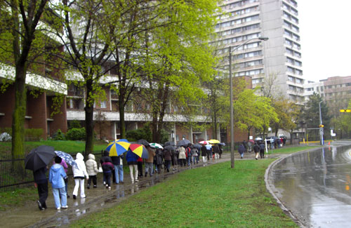
The turnout was remarkably good for a rainy day — well over 30 people came out, a mix of local residents and visitors, with several current and former local politicians. The walk was led by David Lemire, Executive Director of the organization Flemingdon Neighbourhood Services.
The first thing we saw was the central mall, where the grocery store had closed down in the Fall of 2007, despite the community’s large population. The local residents contrasted the situation with Thorncliffe Park across the ravine, where the mall is thriving and there’s more of a community feel. They said that the contrast was in part the result of different planning — Flemingdon Park is broken up into different sections by a hydro zone, ravines, the DVP, and erratic street layouts. The mall itself feels like it’s in its own separate zone, cut off by busy roads and empty spaces, not really connected to the community. In Thorncliffe Park, by contrast, the towers are built in a “U” shape directly around the mall. Access to the mall is easy and direct, a reasonably pleasant short walk from all parts of the community.
Flemingdon Park is making some progress on pedestrian issues — the local councillor, John Parker, noted an improved pathway built through the development beside one of the schools, in a rare co-operative effort with the school board, and described plans for paths across the hydro zone to link up the southern section with the mall and the north part of the community.
But although in theory the community is compact enough to be a thriving pedestrian space, there seemed to be a lot that needed to be done to get there, and it was frankly hard to see how it could be done. Many of the tall apartment buildings don’t face onto the road, and their perimeters are lined by fences. In some cases, there is no separate pedestrian access to the buildings — pedestrians have to walk along a driveway without sidewalks to get to the building’s entrance.

A stretch of road along Grenoble Drive which is lined with an arena and an elementary school on one side, with townhouses and tower blocks full of people on the other, nonetheless feels isolated and cold, because none of the buildings provide an open face onto the sidewalk.
(It’s true that it was a rainy Saturday, not the most conducive situation for a big pedestrian presence — but we saw almost no-one at all on the streets beyond the mall, whereas in Thorncliffe Park on the same day there were quite a few people walking on the streets and paths).
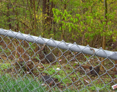
A bit further, on Gateway Drive (south), local resident and activist Louis Fliss pointed out a ravine heading south, fenced off and full of garbage. Simply putting steps and a path into the ravine could link up with the rest of the Don Valley path system, creating regular foot and perhaps cycle traffic that would discourage using the space as a dumping ground.

It was striking how little access the community had to the ravines all around it.
At a reception at Flemingdon Neighbourhood Services after the walk, I met local community organizer Ali Baig, who told me about another pedestrian problem. The local high school, Marc Garneau Collegiate, is on the other side of Don Mills Road from the rest of the community. One of its main entrances is directly across Don Mills from a 7-11. Students tend to cross mid-block, despite several lanes of fast traffic with a blind spot coming up a hill to the south, and despite being less than 100 meters from a traffic light.

But what else are they going to do? There is no sidewalk leading from this entrance to the school to those lights, at the main intersection of Overlea and Don Mills! Students coming out that entrance would have to walk along a muddy track to get to the lights. To top it off, there’s actually a bus stop (not heavily used — rush hour only) along this stretch of road as well, with only a muddy patch on which to wait or disembark. (There is another entrance to the school facing north on Overlea, but it would be a detour from the south-eastern entrance).

To deal with this problem, the city has only put up “do not cross” signs. Apparently that means students can be fined for crossing mid-block at these locations (I am going to have to investigate this issue). Locals want an actual barrier on the median to keep students from crossing — but that won’t be much use unless there’s a usable route to the intersection. The irony of the situation is that this traffic problem is directly in the view of the City of Toronto’s Traffic Management Centre, across the street on Don Mills, which is responsible for managing traffic issues and controlling most of the streetlights in the city.
It’s also worth noting just how unpleasant the Don Mills and Overlea intersection is for pedestrians, with very wide roads and heavy turning traffic. This intersection creates a separation between Flemingdon Park and the community’s high and middle schools.
As I was taking photos of this situation, I was stopped by a very polite policeman who began to question me about my activities. He asked me why I was taking photos, what I was taking photos of, asked to see the pics on my camera, and then asked me for identification and ran my ID through the police data system. He explained that there was a “sensitive building” in the area that they had to be careful about (he had been called specifically because someone in that building saw another participant in the walk taking photos with a professional camera). I’m guessing the building in question was the Traffic Management Centre (its location is not a secret).

The polite policeman is checking my ID in the police car while I wait under the shelter of the 7-11’s roof. In the background is the unpleasant intersection of Don Mills and Overlea, where multiple lanes of traffic separate the community from its schools.
Perhaps they’ve seen the remake of The Italian Job and are afraid terrorists will cause traffic congestion chaos in the city in pursuit of their dastardly schemes. It was pretty surreal — being stopped for taking photographs of public places felt very “eastern bloc before the wall came down” (except that the policeman was, as I said, really polite). Police stopping people for taking photographs or videos in public places seems to be a trend (incidents are being tracked in Boing Boing’s civlib category).
The locals who I’d talked to said that there was a strong sense of community between Flemingdon and Thorncliffe Parks, so after the policeman returned my ID I decided to walk over to Thorncliffe to see what it is like.
Tune in tomorrow to read my impressions of walking around Thorncliffe Park.


25 comments
A really perceptive post; Spacing at its best. And an interesting juxtaposition to the Star article this morning on the students’ campaign for crossing lights at Albert Campbell Collegiate Institute in Scarborough.
The most interesting part of the post to me was the fact you were stopped and questioned by the police. Are they even allowed to do that?
Since Dylan was not being detained, nor being investigated as a suspect in a recent crime, they actually had no right to ask for his ID. Or, more specifically, he had every right to decline providing it.
(If you choose to decline in such situations, it’s best to be polite with officers, ask if you are being detained, and, if not, pleasantly inform them that you will unfortunately have to withold your ID, but only in the interest of privacy and Charter rights. You aren’t even required to give them your name. Unless you’re being detained you have no obligation to speak to an officer at all, though refusing conversation outright can actually be a good way to get detained 🙂 )
They can ask but you have no obligation to answer.
I don’t care how polite the guy in dark blue was, he wouldn’t be seeing my pics on my camera and
would never see my ID.
Sure the lazy thugs will question a guy taking pictures but report a dude threatening you with a gun, being sideswiped by a car while you are on your bicycle or a couple of people assaulting you on the street and they won’t lift a finger. Trust me on that, I know from different experiences.
I’m disappointed the cop asked to see both your photos and your ID. If he looked at your photos first, ideally he’d say goodbye as soon as he realized you weren’t taking intrusive photos of the Traffic Management Centre. (BTW, their address is also listed on the Toronto Police web site!)
As for whether the cops can get involved at all, check out this recap of the laws involved. Assuming you weren’t on private property, it looks like their only grounds would be under the Security of Information Act, which seems a bit of a stretch for the traffic light control centre. Though you never know when transit extremists will take transit signal priority into their own hands… 🙂
Oops, a minor correction to my comment – “Unless you’re being detained you have no obligation to speak to an officer at all,”
That “unless” part wasn’t what I meant. You have no obligation, period.
What a load of BS. A “sensitive buildingâ€Â. I don’t even know where to begin with this but I guess using a “professional camera” is the sure sign of guilt now.
The best answer, none of your business. I hate it when police and security guards invoke rights they do not have.
I agree with the above comments about the officier’s uneeded questioning of Dylan, but let’s try not to turn the comments of this post into a bashing of cops. Dylan raised some very important issues about pedestrian that shouldn’t be overlooked. Correcting these issues are cheap and effective. Installing a crosswalk and managable sidewalks should be the priority in front of this school.
Re. the police officer asking for ID – I was pretty sure I shouldn’t have to show it, but I knew the police officer would say that protecting the “sensitive building” was a reasonable cause, and while I was also sure a court would probably dismiss this as a reason to require ID, my goal for the afternoon was to go for a walk in Thorncliffe Park, not start a constitutional test case, so I decided to just ride it out. I did find it disturbing, though, which is why I’ve told the story. The comments have helped clarify the situation a lot – thanks.
My favourite part of the exchange:
Policeman: “Have you ever been in trouble with the law before, sir?”
Me: “I hope I’m not in trouble with the law *now*, officer”
Policeman: “No, no, of course not, no”
Also, I love the idea of a “sensitive building.” Maybe the building is so sensitive it would get upset if I took pictures of it. “Oh no, I look terrible,” it would complain, “that’s not my best side. And the light is unflattering today.”
Thanks for the helpful article documenting a wonderful Jane’s walk and handily noting some of the community’s issues. If education is a stepping stone for civic engagement then Jane’s walks will be an even greater innovation than their immediate value.
By the way the building across the road handles all the 911 calls across the city, which may explain the police nervousness (it may also be a traffic management centre)
You did the right thing to save yourself a lot of unnecessary hassle Dylan, that’s for sure. I just get upset by how much we get pushed around by so-called authorities but they rarely seem to help out when needed.
Molly is of course right, the issue from this post should be the awful neighbourhood planning we suffer from in this city.
I love to walk but it seems as if you are an unwanted nuisance to traffic the way things are built sometimes. A sure sign of the rise of the car and decline of the pedestrian was the disappearance of the front porch. It is making it’s return now but for decades the garage replaced the porch where people used to sit and greet passersby. A whole new realm is opened up when one sits on the porch.
Geoff> “By the way the building across the road handles all the 911 calls across the city, which may explain the police nervousness (it may also be a traffic management centre)”
Well now that you have told everybody you will be arrested you because you make us nervous. : )
Scott, I doubt it. Note the address at the bottom of this job posting for 911 operators. Its location is no secret.
I agree with Geoff — Jane’s Walks are off to a great start for only two years. For me, the best part is hearing about the areas from a local perspective — sometimes the locals’ experiences reinforce contemporary planning ideals, but sometimes they challenge them too.
Getting aside from this cop/photo biz, I’d be careful about making too much of the “awful neighbourhood planning” aspect of the walk; in fact, depending on the backgrounding offered, it could just as well be an opportunity to re-appreciate a lot of the best of the original aesthetic: the serpentine blocks, the townhouses, all that seemed exhilarating back in its time and could use a little love rather than abuse again.
As for the mall, its main problem was probably that it was too terminally a “community plaza”, whereas Thorncliffe Market Place was more genuinely a hub (and IIRC the first “enclosed” mall in Toronto), as was, of course, Don Mills. Still, it’s surprising to hear the grocery, even in its Food Basics incarnation, is no more…
I would also think that the proximity to the new Super Centre at Don Mills and Eglinton had something to do with the grocery store closing.
Interesting about the 911 centre – it must be the same building as the Traffic Management Centre. I’m not sure which of these services would cause the sensitivity. Perhaps there are also other services there, like emergency management, that we don’t know about that cause the “sensitivity”.
For the pedestrian crosswalk idea from the school – unfortunately, Don Mills is too wide and busy to fit the city’s criterion for a crosswalk, as well as probably being too close to an intersection. I’m not sure if there’s a perfect solution to the problem they have, but a sidewalk would certainly help.
Apartments without even a sidewalk to the front door are also large issues, along with the trashed ravine that all those people can’t access are also real issues. All those barriers mentioned in the article can make life in affected neighbourhoods uninspiring and frustrating.
Thanks Dylan, great post.
Let me add a few details, and begin by suggesting one flaw I didn’t notice in your post.
1)Eglinton Avenue, and even more accurately, the large vacant tracts of land on the north-east and south-east corners of Eglinton and Don Mills.
For those who are unaware, these giant vacant swaths were acquired by the City of Toronto (well the former METRO) to create flyovers at the intersection. (ie. Eglinton would have passed under Don Mills or vice versa, with ramps connecting the two, similar to a highway)
If the City hadn’t held on to this land for no good reason, that new Loblaws might have been built within the Flemingdon community, or at least directly across the street instead of being a long block up on a not-so pedestrian friendly road.
The City remains the owner….
2) The existing plaza, though centrally located to most Flemingon Residents is also positioned so that very few people from outside the community might make use of it. As it sits only on Don Mills, away from the 2 major cross streets (Overlea and Eglinton). That said, I think it really should be viable, given the high density of the area, if it were fixed up, and if it featured better pedestrian connections to it.
Perhaps this is is an opporuntity to look at redeveloping the plaza with mid-rise, mixed-income housing with ground-floor retail?
3)The access to the valleys is somewhat limited, though not necessarily as poor as it first appears.
However, many of the accesses are nearly invisible, and if you didn’t go looking for them you wouldn’t konw they were there. Many also lack improvements which given the appearance of proper park entrances.
This is true in both Thorncliffe and Flemingdon.
There is access to the valley on the west side of Don Mills (old road alignment of Don Mills pre-DVP), quasi-paved, but the access is in poor condition, un-signed, and there is a gap between it and the nearest sidewalk.
There is also access to E.T. Seton Park (the valley below the Overlea bridge) via a City Yard just south of the Science Centre. However, I don’t recall their being sidewalks or an environment encouraging people to use that entrance.
Students do, by the way, enter the park on the North side of Overlea bridge coming down the hill. (there is no path or stairs and its not an easy descent). A staircase there would probably make good sense.
Access to the East Don Valley (east of Flemingon) is quite limited, largely because the DVP runs between that valley and most of the community. Another factor is that there is no trail in this area as this is a ‘Conservation Reserve’ (on the west side of the river); and on the east side, you have Flemindon Golf Course. There are very few ways I can imagine access here, unless of course the City takes over and shuts down the golf course.
3) I want to make a final point about the bizarre road layout. It certainly hampers people in the area and even makes it confusing for drivers, never mind pedestrians! While it can’t be completely fixed in the absence of tearing everything down and starting over, there should be a way….. Say though that city owned land??? to create an additional north/south access to Eglinton which might make the local roads a bit more grid-like and sensible.
The city’s inaction on those two corners may still have benefits. The intersection of two major Transit City lines (the Eglinton LRT and Don Mills LRT) could use some sort of off-street transfer facility either on one corner or underground. That’s yet another reason to improve walkability in and around the intersection.
Also due to the unfortunate street layout in the area, the TTC route 100 Flemingdon Park has the distinction of being a painfully long, roundabout route with a route map completely impossible to read (http://www.toronto.ca/ttc/schedules/100map.GIF).
I discovered the hard way that if you want to get from Bayview and Eglinton to East York Town Centre, its DRASTICALLY quicker to do any of the routes along Eglinton eastbound and then 25 don mills south, instead of just hopping a 100. You can burn 20-25 minutes easily riding in circles around the buildings in Flemingdon Park on the 100.
Oh, dear. That looks kind of like an Ottawa bus route:
http://www.octranspo.com/Timetables_DB/Current_TT/map.asp?route=6
http://www.octranspo.com/Timetables_DB/Current_TT/map.asp?route=14
Hey there was just wondering if you knew where I coudl get a map of the paved trails (Sunnybrooke, ET Seaton, Wilket Creek etc..) I know they are all joined someone but Im looking for a MAP so that i can navigate my way throught it, downtown even.
thanks
P.S. “sensitive building” Im sure had NOTHING to do with the Traffic centre or whatever it is…it’s probably becuase the neighbourhood is known for high crime, and also becuase you were outside a school, anyone taking pictures outside a school is usually labelled “suspect”.
Hi Niya,
The City of Toronto has 2 maps that show all of the paved trails.
One is called “The Parks & Trails Map”
Its available on-line here
(front)
http://www.toronto.ca/parks/brochures/parks_trails_1.pdf
(back)
http://www.toronto.ca/parks/brochures/parks_trails_2.pdf
Hard copies should be available (it used to be) at most Rec Centres. If not, phone and ask the Parks dept for one.
The other good choice is the City of Toronto Cycling Map.
Its available online at http://www.toronto.ca/cycling and at most rec facilities, civic centres and libraries.
It shows all the bike lanes and routes both on streets and in parks.
Hope that’s helpful for you.
via a friend’s blog…
http://www.sindark.com/2008/04/23/your-rights-as-a-canadian-photographer/
I appreciate the Jane’s Walks in that no matter how poorly planned or aesthetically inclined a neighbourhood may be, the hosts always emphasized the strength of the local residents in building a close knit community, no matter what physical obstacles got in their way.