


This is part of a series of posts by students in OCAD’s Cities for People summer workshop (click the link to read a bit about what the class is about). This Fort York post was researched and written by Amanda Compagnone and Stephanie Reich. Click here to see a larger version of their psychogeographic map of the area.
![]()
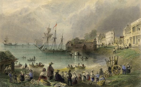
The Fort York neighbourhood is located south of CN and CP railways between Strachan Avenue on the east and Dan Leckie way on the west, and extends south to the Lake Shore. Currently this neighbourhood is ever-changing and, at some times of the day, seems like a residential ghost town. It also contains historically rich sites such as Fort York garrison along with a few existing industrial buildings, some of which have been converted to meet the need for residential uses in the area, while others are still in need of restoration. Amongst the converted buildings is the ‘Tip Top Lofts,” the original manufacturing, warehousing, retail and office operations of Tip Top Tailors Ltd. built in 1929, designated as a heritage structure in 1972 and converted to lofts in 2002.

This neighbourhood poses specific challenges with regard to new developments as some of the soil is contaminated near the original shoreline as it was previously industrial and railway lands. In addition to this challenge, excavation is difficult as the former Garrison Creek, which has since been filled in, seeps to the surface several feet below grade and it is imperative that none of the bodies from the War of 1812 — which rest near the garrison — are disturbed. Despite these site specific issues, the area is in the awkward phase of its mixed use, high density face lift, leaving some of its history in the dust of new development, with only fragments remaining.

The 35 storey residential building “Malibu” on Fleet Street near Lake Shore Blvd. and Bathurst marks the location of the long-buried Queens Wharf, remains of which where discovered while excavating the high rise’s foundation. A commemorative sculpture by Vancouver artist Douglas Coupland now rests in its place, depicting the Fort York attack on April 27, 1813. The gold soldier of the British, Royal Newfoundland Regiment stands on a toppled silver, American soldier, representing Canada’s victory.
In 1793 Lieutenant Graves Simcoe certified the garrison at York to protect Upper Canada, it’s strategic positioning just west of Garrison Creek on the shore of Lake Ontario was ideal for defense due to it’s proximity to the United States boarder and for its natural harbour, which guards the western entrance to the bay.

The War of 1812 took place between 1812 to 1815, and was fought largely on the Atlantic Ocean and the on North American Coasts. The fort was used to shield the new settlement and the capital of the Upper Canada from a series of army attacks from the recently independent United States. The British Army inhabited Fort York from 1793 to the 1850s, later the land was transmitted to Canada and was active until 1932. The original structures consisted of Stone powder magazine, North and South Soldier Barracks, Block houses 1 and 2, Officer’s quarters, Blue Barracks, Brick Powder.


Immediately after the war of 1812 Royal Engineers worked to restore the fort at its original location west of Bathurst, previously the west bank of Garrison Creek. In the 1950s Fort York was nearly paved over to allow for the Gardiner Expressway, however planners eventually decided to elevate the expressway and rerouted its path south of the historic grounds.


In the late 19th and early 20th century the inner harbour was filled to meet industrial demands, extending Toronto 800m South of the original shoreline and is now being developed into a mixed use, high density condo towers limiting visual connections to Lake Ontario. The majority of the fort’s original structures were lost including the soldier training base, barracks, offices and storage, however, in 1934 the remainder of the restored buildings were opened as a historic site museum.


Garrison Creek was 6 km long and fed by a source near St. Clair Avenue and Humewood Public School, in addition to a source close to Dufferin Avenue and St. Clair, flowing southeast into the Toronto harbour. In 1880 the city started to divert the creek underground to sewersc allowing water to flow under the city streets, by 1920 the entire creek was buried.


There are many artifacts marking the creek’s existence, including buried bridges near Harbord and Crawford, in addition to the Garrison Creek Discovery Walk, a path tracing the original course of the creek, starting at St. Clair, through to Trinity Bellwoods Park, and finishing at Fort York.


Despite the areas’ historic sites and significances, the scale and frequency of construction in the neighbourhood makes it difficult to enjoy and accurately appreciate such features. As the area is still being developed into its mixed use, high density, there are currently few stores and cafes in the area making it difficult to wander in the summer without getting near-heat stroke. Coronation Park is the only green space in the area other than Fort York, which is often occupied by school groups during the day. The well manicured Coronation Park offers an oasis of shade in the concrete desert. However, the park is very difficult to get to as there is only one pedestrian crossing of Lake Shore Blvd. between Strachan and Bathurst and once within the park noise from the traffic, construction, and planes nearby make it nearly nearly-impossible to have a conversation with someone more than a foot away.
Click here to see and hear construction on the Gardiner and here to hear the sounds at Coronation Park.
The City’s Public Realm Plan intends to address these issues, the lower floors of the high rise condos will be dedicated to commercial space, the addition of low-rise housing and town houses will make the area predominantly residential. This master plan contains plans to improve public spaces between buildings, accessibility through the public transit system, as well as improving cyclist and pedestrian paths and roots while adding waterfront connections, green spaces, improved views to and from Fort York as well as several streetscape ideas. Upon completion of this tall order, it will be possible to comfortably experience the Fort York neighbourhood and appreciate it’s lush history. Until then, bring your own water.

3 comments
Great article on the creek. Thanks.:-)
If the Coupland toy soldiers are supposed to commemorate a Canadian victory, it didn’t happen in April of 1813. The Americans .. who outnumbered the defenders .. won a clear victory at the fort and went on to occupy the town of York and burn the legislative buildings. Maybe the Canadian toy soldier represents toppling the Americans the next year, when they were repelled at a rebuilt Fort York.
Great historical piece.
Looking forward, June Callwood Park will add another green space to the neighbourhood that will create some sense of transition from Fort York to Coronation Park to the Lake:
http://www.toronto.ca/parks/June_Callwood_Park/index.htm