


This is part of a series of posts by students in OCAD’s Cities for People summer workshop (click the link to read a bit about what the class is about). This post is a follow up to Ilona Valcov, Andrey Chernykh and Michael Sudiacal‘s first post exploring The Port Lands. This is their design proposal for the neighbourhood.
![]()
Transformation of Unwin Avenue

Site plan of design intervention featuring future development in the area.
The street will see an evolution from heavy industry to a pedestrian prioritized destination as part of the future Lake Ontario Park in Port Lands neighbourhood.
Concept
The street is a threshold that separates the North industrial side of Portlands and south recreational part. It is currently a link connecting the east and west ends of the neighbourhood. What happens when a link starts to embody qualities of a destination into it? Negotiation of movement and stability presents itself in form of a reduction of speeds, of cars in particular, as well as the addition of cyclist and pedestrian speeds. The road was used as a transportation vein to deliver materials from A to B will mutate into a place of lingering and partial stillness. The street takes on a role of a promenade — a link and a destination — reflecting back on heavy industrial activity of the past through the concept of “disintegration,” which is will be evident by the choice of paving material. Unwin will become a “complete street,” where various speeds, vehicles and pedestrians can mingle safely. The stillness aspect is manifested in shape of street furniture and places for rest which speak strongly to the neighbourhood’s history and development through the use of materials and symbolism. The road begins to communicate so much more in its small scale; it begins to represent an evolution not only of itself but of the entire neighbourhood.
The transformation is geared towards a future development of Port Lands and considers implementation in the next 30-35 years
Materials
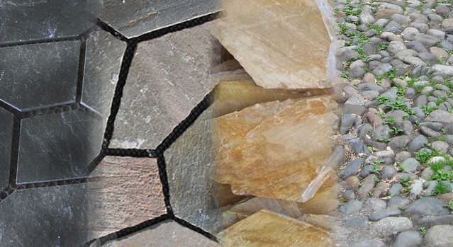
Paving pattern of the Unwin Ave
The materials employed are rough in their finishing, particularly in paving applications, to commemorate the history of industrial activity and serve as a way to slow down fast moving vehicles. Stone and granite tiles are used for paving and are arranged in a gradient starting with dark tiles and ending with earthly ones organized in a more broken down pattern. This provides a strong symbol for the death of the heavy industry’s shipping and moving activities. The street furniture involves street lights made out of I-beams as well as seating made out of treated tree stumps salvaged from a nearby snow dump site.
Vegetation
The vegetation of the area ranges from native prairie grasses to native trees. Apple trees would be planted along the road and well into the hill area (see below). Revitalizing the area begins with removing invasive trees and shrubs that currently feed off the moist and nutrient-rich soils of the Port Land hiking trails located around the current snow dump site. These will be replaced with native Toronto trees and bushes that thrive with the Port Land sun and soil conditions such as Silver Maple, Yellow Birch, Button Bush, Turtle Head, etc. Mixing coniferous trees with high density deciduous trees and plants ensures greenery all year while adding flowering plants like thin-leaved sunflowers and dense blazing stars adds texture and colour throughout spring and summer seasons. Part of naturalizing the site also involves cleaning and integrating a canal system in the present ditch area that utilizes bio-filtration so that water from the streets do not leak and contaminate the nearby lake. The stream in turn is transformed into an attractive water feature for pedestrians to interact with.
The first step in such revitalization is to establish a soil recycling facility which Waterfront Toronto has recently proposed. Only after the soil is recycled and cleaned of pollutants the native plants and trees can begin to thrive and transform the neighbourhood.
Avenue Zones
The intersection of Cherry St. and Unwin Avenue will feature pedestrian crossings allowing safe access onto the promenade. The zones around the avenue are filled with benches and picnic tables for rest and socializing. The railroad is converted into an additional pedestrian pathway which transforms this historical artifact into an interactive feature. The road is a shared zone for cyclists, pedestrians and cars through the elimination of the curb. The inspiration for it came from looking at the University of Toronto St. George campus that features roads that are free of noticeable curbs and borders between the sidewalks and road are blurred to encourage sharing. The paving is made out of textured granite and stone tiles in order to slow down the cars in the area and allow for pedestrian dominance. The street ends in paving being dispersed and spilled into the zone where previously snow dumping was employed.
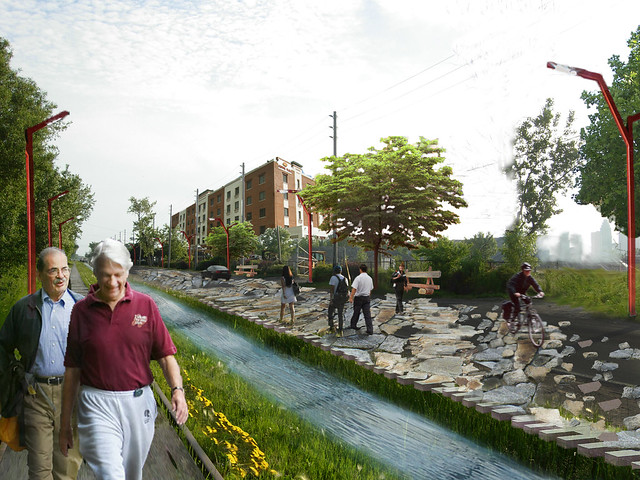
Rendering of Unwin Ave featuring the disintegration of the road
Snow-dump zone

(Photo by Val Dodge — Where’d the snow go?)
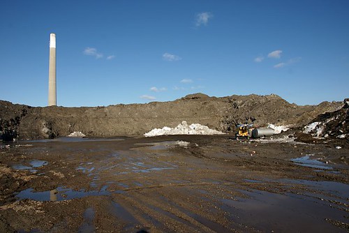
Current (winter) condition of the dump site. (Photo by Val Dodge — Snow Mountain Revisited)
As one walks off from Unwin Ave the cobblestones are dispersed and road disintegrates making way for high hills. The 3 hills materialize from the ground reminiscent of piles of industrial material that existed in the neighbourhood for so long. The hills are lined with native prairie grasses and feature chunks of stone paving impregnated in the surface of the hill. The hills acquire a mutated character that speaks of the scars that the industry have had on the soil of that area. However, the hills themselves acquire a new recreational life dedicated for pedestrians and campers. They serve as a monument to the bygone era and a symbol of the metamorphosis of a landscape.
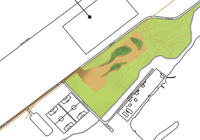
Plan of the proposed hills
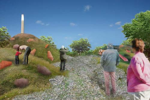
Rendering of a snow-dump area after the transformation


4 comments
The rendering of the disintegration of Unwin is curious. So much is done to transform and beautify the street, but in the background the hydro wires and wooden poles remain.
Must keep it ‘messy’ A.R. Toronto’s gift to the world is ‘messy urbanism’ dontcha know?
I’m surprised that other cities don’t jump on this design bandwagon, other than third-world cities that don’t have a choice.
If we don’t wean ourselves off the current goods transportation system, based on fossil fuel powered trucks, we won’t have to worry about Unwin Avenue; after peak oil makes deliveries to Toronto impossible or impossibly expensive, we’ll have grass growing on Yonge Street. The only goods transportation technology we have now that doesn’t depend on fossil fuels moves goods by water, and if we destroy the port, as eager urban designers and developers seem to want to do, we can’t use it. I predict that a century from now, Unwin Avenue will have a large number of high-technology sailing vessels tied up at the basin, unloading goods onto electric trains and trolley trucks for distribution throughout Toronto and the GTA. It won’t make for a contemplative environment, but it will pollute a whole lot less, and it will survive the end of cheap oil.
Thanks everyone for their comments!
I think as Portlands are transforming into a largely residential neighbourhood, the industrial activity would become impregnated into the various buildings going up in the neighbourhood, in a form of green technologies generating energy like solar panels, wind turbines etc. As for shipment of goods, the edges of Portlands would still be maintained as docks for that purpose as well as some recreational activities. I don’t think the ports will be destroyed and some shipping/industrial activity will definitely stay but it would be (hopefully) in much more cleaner and responsible state responding to a neighbourhood transforming into one that is for the people not machines.