If there’s any takeaway from the recent PriceWaterhouseCoopers report ranking Toronto second behind New York City for the world’s best city for finance, innovation and tourism, it’s that the two have many similarities, not that they’re the best. Studies like this, along with livability reports and commute time rankings, should rightly be read with a healthy degree of skepticism. But what stands out about this one is how it paired New York and Toronto so closely.
The report ranked 26 cities in 66 categories ranging from airport access, end-of-life care, skyscraper construction activity and housing to a category called “life satisfaction.” In over half of the 66 categories, Toronto and New York ranked within five points or less of each other.
Hearing the two cities in the same breath many not be unusual in Toronto, but it is in New York. Attending several urban planning events in New York last week, Toronto actually came up in several presentations as having some unique programs that New Yorkers thought their city could learn from. I thought Spacing readers might be interested in hearing what Toronto programs were grabbing their attention, as well as hear about some neat initiatives in place in New York that could be tried in Toronto.
1. Participatory Budgeting at Toronto Community Housing
Participatory budgeting is at the extreme end of the public participation spectrum, actually allowing members of a certain community – in this case, TCH tenants – to decide how an organization or even a government’s budget is drawn up. Since 2002, residents of Toronto Community Housing have been deciding how $9 million in capital funds is to be spent annually. In Chicago’s 49th Ward, a similar initiative is being tried.
Don’t let the mundane title put you off, this award-winning report is anything but ordinary. Chock-full of capital budgeting programs, revisions to the development review process and pedestrian safety strategies, this study is quietly informing planning departments around the world. Indeed, New York City’s groundbreaking 2010 Pedestrian Safety Study & Action Plan essentially added traffic statistics to very similar-sounding material, putting meat onto the bones of the principles outlined in Toronto’s earlier report.
3. “From Back Home to Our New Home”
Even in cities with some of the most active bicycle strategies, obstacles facing immigrants and minority communities to safe cycling remain large. Toronto’s language-based strategy of translating the Toronto Cyclists Union Handbook into many different language, creating multi-lingual posters and organizing programs for newcomers is therefore of interest to many cities who face similar challenges getting certain community members on bicycles.
On the flip side, a few lesser-known New York initiatives relevant to Toronto include:
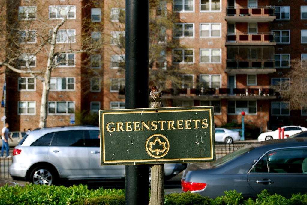
1. Safe Streets for Seniors/GreenStreets
Although technically two separate programs, both strategies look to re-purpose poorly used road space to make the streets more livable for residents. Safe Streets for Seniors tightens up intersections and roadways to make them safer for pedestrians, with interventions ranging from painting a slightly wider curb onto the street to making raised concrete pedestrian islands. GreenStreets – a joint effort by three City departments – similarly re-purposes extra road space by creating islands, street medians and extended sidewalks that make streets safer. Yet it goes one step further by installing porous surfaces like trees, flower beds and other gardens to better manage storm water runoff and improve air quality.
2. NYC BigApps 2.0
With Toronto’s Open Data site starting to populate with spatial data, contests like NYC BigApps 2.0 that take advantage of all the amazing creativity of the City’s tech community should be encouraged. This contest gets software developers to compete for $20,000 and a meeting with the mayor by creating applications and web platforms that make a positive impact on the City. Past winners include Roadify, an app that not only finds you on-street or off-street parking, but then links you to nearby transit service schedules.
3. Rezoning tools
Much has been made of the re-zonings conducted by Planning Commissioner Amanda Burden over the last nine years, and for good reason – new bulk and design regulations that prioritize pedestrians and transit-oriented development now blanket one fifth of the city, or over 9,400 blocks. But overshadowed are little district-specific amendments like limiting banks to the second floors of new buildings on some commercial streets rather than letting them deaden the streetscape. Another is the creation of a Zoning Handbook that uses cartoon illustrations and clear writing to give the community the language, tools and know how to take part in rezoning discussions that shape the future of their communities.
photo by Michelle Star