
EDITOR: We’re pleased to publish a guest essay by Kanishk Bhatia, a Toronto resident who recently returned to the city after living in London, England for two years. Since he’s been back, Kanishk has enjoyed rediscovering old favourite spots as well seeing all the changes in the city through a new lens. Kanishk is on Twitter @Kanishk_Bhatia
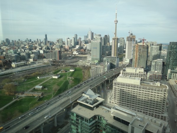
Looking eastward through my 34th floor living room window at the cluster of condo towers in front of me and the soaring CN Tower jutting out through the forest of downtown buildings in the background, I think back to my first brush with this part of town. My wife and I were looking for a rental apartment in the Harbourfront area and our agent took us out to “Fort York” to show us a new building in what could generously be considered the western edge of the downtown waterfront.
I distinctly remember walking past a red brick building (Molson brewery) in the process of being demolished next door to the tall all-glass condo building that we had come to visit. There was also a cement plant nearby with trucks rumbling in and out spewing clouds of dust. Other than the partially-standing brewery and cement plant, this condo was one of only two buildings along the north side of Lakeshore Boulevard in this otherwise empty stretch of land.
That was 2005.
Fast forward 9 years to today. I’m staring out my window at nine buildings – a mix of mid-rise and high-rise – in what is becoming a fairly densely populated residential community now known as the “Fort York neighbourhood”. Beyond these buildings, I see another huge set of glass towers (City Place) in front of me and the rest of the downtown skyline a bit further in the distance. Casting my eye towards the north, the sweeping views from this high up offer a unique view of Toronto. For one, you get a real sense of the high-density development along the Yonge subway corridor, with buildings of varying heights packed closely together, stretching from near the lake all the way to midtown. As well, you can count a fair number of the “150 cranes in the sky” that Rob Ford likes to talk about – including one jutting out of the 70+ storey sleek skyscraper at Yonge and Gerrard – an exclamation mark of sorts on the staggering recent upward rise of downtown Toronto.
Another thing you notice from this vantage point is the surprising diversity of transportation modes serving the city – the 511 streetcar rumbling across the Bathurst bridge, GO and VIA trains rolling in and out of Union station, Porter planes descending into the island airport, cars speeding along the Gardiner Expressway and Lakeshore Boulevard and even ferries plying the waters of Lake Ontario. For a city that loves to moan about its second-rate transportation system, it is somewhat interesting to see – in one glimpse – the multitude of ways to get into and around a big city.
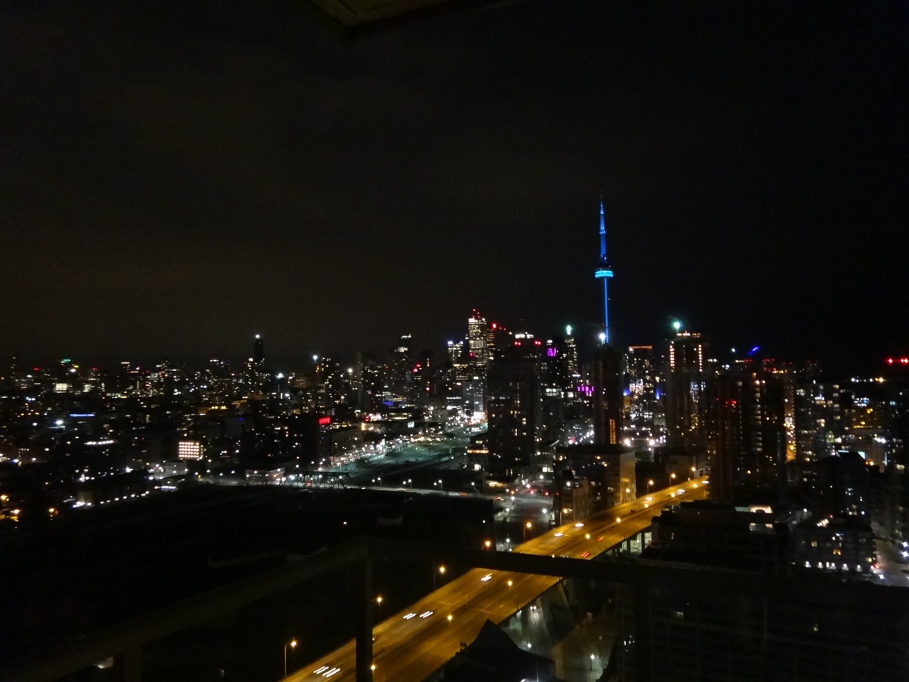
As an aside, the view at night offers a totally different perspective – peeks into lit-up condo units (boxes in the sky, one might call them), multi-coloured lights shining across the downtown towers and CN Tower and the much-maligned Gardiner looking more like a flowing river of lights than a crumbling 1950s-era highway.
With the obvious signs of development visible directly in front of me, I sometimes pause to reflect on the change that has occurred on this particular plot of land between Bathurst Street and the Princes’ Gate (entrance to Exhibition Place) and bounded by historic Fort York to the north and Lakeshore Boulevard to the south. Much of this section of the city, together with surrounding land south of the rail corridor, was previously re-claimed from the lake and had a largely industrial character for decades. With the eventual displacement of industry, this “dead” space has been transformed into a new residential neighbourhood literally started from scratch – one of several such developments in Toronto in recent years. Today there are thousands of people living here who collectively represent a new chapter in Toronto’s continuing growth.
Unlike City Place to the east which has a relative “sameness” in terms of architectural style (due to much of it being built by a single developer), the ownership of plots was dispersed amongst four developers here, which has had the effect of a slightly more varied mix of building types sprouting up. The City of Toronto went through an extensive master planning process to guide the development of this new neighbourhood in line with its desired city-building principles around elements such as transit access, public realm elements and integration with existing heritage features.
While it could be argued that the term “neighbourhood” may be pre-mature given the area’s development is still very much a work-in-progress (new building construction is still on-going), one can start to see the early signs of a sustainable residential community taking shape. To be sure, it is easy to point out a number of shortcomings based on what exists today, such as the limited public amenities and lack of vibrant street life. However, given the still evolving nature of the development context, it might be wise to wait at least another 10 years before one can reasonably assess the success or failure of the city’s vision for this neighbourhood.
As a resident of the evolving Fort York neighbourhood, I wanted to share my impressions of what stands here today and how this area might mature in the years ahead.
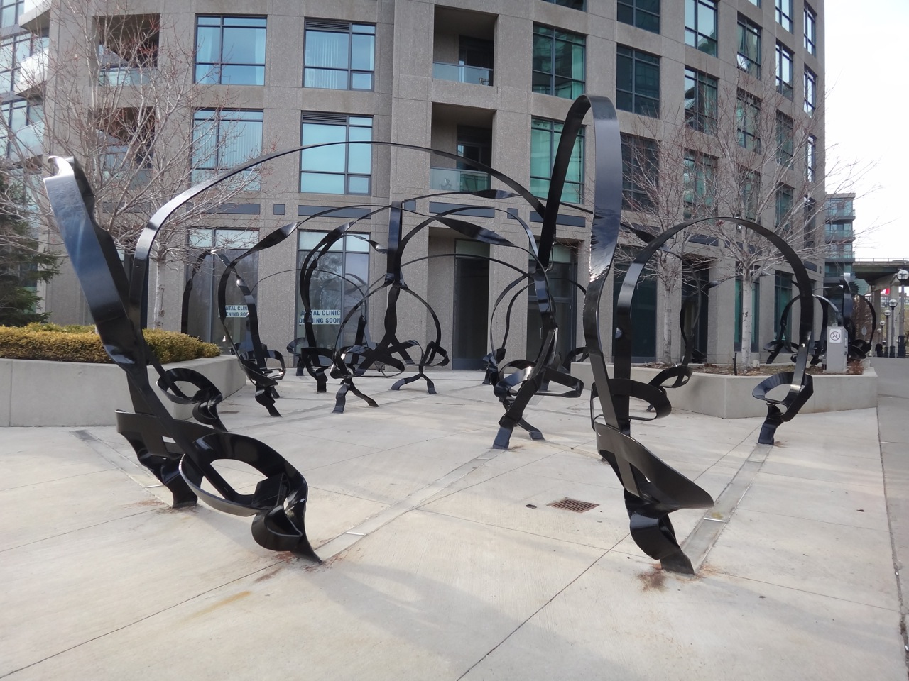
Stepping out from my building near the corner of Fleet Street and Fort York Boulevard, I walk past a twisting black metal structure designed by New York architect Vito Acconi (part of this condo developer’s contribution to the City of Toronto’s “Percentage for Art” program) that could be considered part-art and part-street furniture. It’s a somewhat bizarre but bold medley of twirling metal “ribbons” that intertwine and rise up several feet in the air before coming down to the ground in the shape of seats. I like the installation, but I can’t help but feel it could have had more impact if they had stuck with the original design vision illustrated in the early renderings which showed pink and blue hued-metal ribbons instead of the black painted metal that stands today. Nonetheless, it’s a welcome addition to the streetscape which I’m sure some people have noticed while walking or travelling by streetcar along Fleet Street on the way to Exhibition Place.
Walking east towards Bathurst Street along the expansive Fort York Boulevard (designed with a view to potentially run light rail down the middle of the road in the very distant future) along the northern boundary of the neighbourhood, you’ll find yourself crossing under the Gardiner with views of the grassy mounds of Fort York to your north. The rows of massive pillars holding up the expressway frame a nice view of the structure’s “underbelly” and give you a great sense of its height – easily six or seven floors high. I’ve always felt this cavernous covered space under the Gardiner would be ideal for an open-air movie night or a farmers market, but nothing much has been made of this space yet. Although, the new Fort York Visitor Centre currently under construction might bring a new vitality and purpose to this stretch.
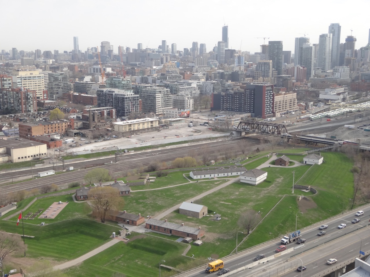
Walking along the wide sidewalks lining Fort York Boulevard on summer evenings, I always keep a lookout for the furry little groundhogs typically seen munching grass on the Fort York mounds. I recall an instance when one of them somehow ended up on the “wrong” side of the fence separating the Fort lands from the grass patch and sidewalk along the street. My wife, a fan of the furry ones, scampered toward it in an attempt to “catch it” which of course sent it scurrying back under the fence to the safe confines of Fort York. Walking home from work, I’ve always enjoyed spotting these animals seemingly standing guard on the Fort’s lush greens – a welcome glimpse of “wildlife” near the heart of the city.
The Fort itself has made great efforts in recent years to expand its footprint in the city’s consciousness by hosting summer festivals and concerts on its adjoining grounds, bringing in loads of people to this previously isolated pocket of the city. As well, the presence of the Fort offers a unique geographic closeness between the new condo towers and an important historical Toronto landmark. However, speaking as a local resident, I don’t feel that this proximity has translated into a particularly meaningful linkage or mutual curiosity between the two neighbouring groups so far. The green spaces surrounding the Fort do offer easily accessible walking areas for the many dog-owners in the neighbourhood and pleasing views from the condo units above, but beyond that, there does not seem to be a great deal of interest among residents in the Fort itself. Perhaps the new Visitor Centre, which will include some social areas and community meeting rooms, can be the glue that binds the two groups closer together.
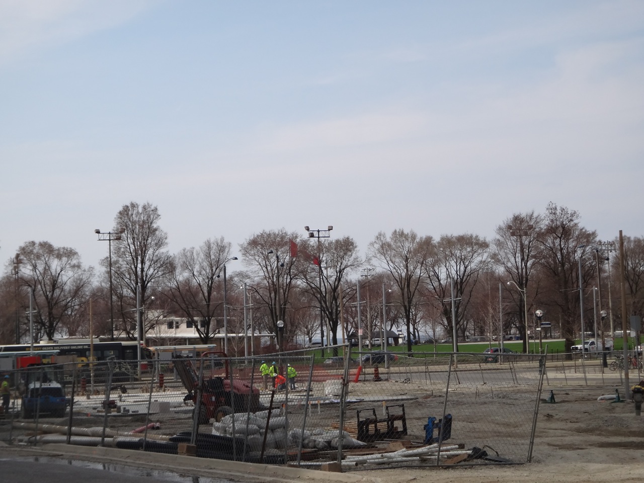
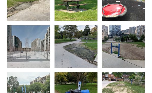
Heading south from the Fort, you come across a narrow cleared plot of dirt stretching from Fort York Boulevard south to Fleet Street. This is the future home of a new park named after activist June Callwood. An international competition was held to select the design team for this sliver of parkland that will sit between two condo complexes and add a much-needed public space dimension that should help to stitch this neighbourhood together. Despite the delays in getting construction started, I have huge expectations for what this park can be – a place to relax with friends or family, for kids to play or simply for pedestrians to enjoy walking in. I’m hoping this park becomes a core hub that will help make this area a lot more pleasant for residents and visitors. The park itself is apparently quite innovatively designed with a special focus on children-friendly features such as a “puddle plaza” for kids to splash around in, a rubberized “pink field” surface as a play area, a “puzzle garden” comprising a series of benches amongst a series of gardens and trees. I’m curious to see whether what is actually built lives up to its ambitious design.
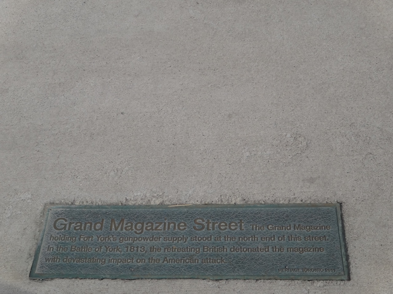
Walking around the newly created inner roads amongst the condo buildings and townhouses, you may notice some curiously named streets like Sloping Sky Mews, Grand Magazine Street and Bastion Street. The City of Toronto went through a process to pick names to recognize elements of the neighbouring Fort York and important figures over time – a historical shout out of sorts. I think that’s a nice touch, and it has been made more relevant with plaques embedded in the sidewalk describing the origin and significance of the names which is helpful in linking the stories of the past with what stands here today. As a further effort, incorporating some references to the area’s more recent uses (such as the St. Mary’s cement plant and Molson brewery) would be a welcome addition in keeping alive connections to the area’s history.
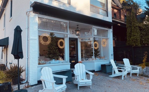
One of the downsides of the streetscape at the moment is the general lack of pedestrian life or bustle. This is partially due to some areas still being an active construction zone, but more likely caused by the absence of any interesting retail or commercial offerings in the vicinity. Walking along Fleet Street that lines the southern end of the neighbourhood, you will come across two dry cleaners (strangely, they sit side-by-side), a real estate broker office or two, a couple of small businesses and a TD Bank. Continuing further down to the corner of Fleet and Bathurst (an ugly intersection with Lakeshore Boulevard thrown into the mix), you’ll encounter a Scotiabank, a dental clinic, nail salon and a Subway.
I’m not sure how much thought went into the retail and commercial side of things during the neighbourhood planning stage, but clearly, its slim pickings for anyone looking for a good reason to linger about at the moment. I’m hoping the June Callwood Park and the striking angular glass-walled Fort York library that recently opened at the corner of Bathurst and Fort York change that by offering people a mix of enticing public places to gather and mingle. As well, as the last set of buildings are completed and more people move in, the area will begin to settle further, improving the chances of more shops and cafes coming in. I recently noticed some new signs posted signaling the impending launch of a small restaurant opening at the base of one of the condo buildings along Fleet Street. I’m sure the many residents who, to date, haven’t had a place to grab a snack within steps of their homes will welcome this new spot with open arms.
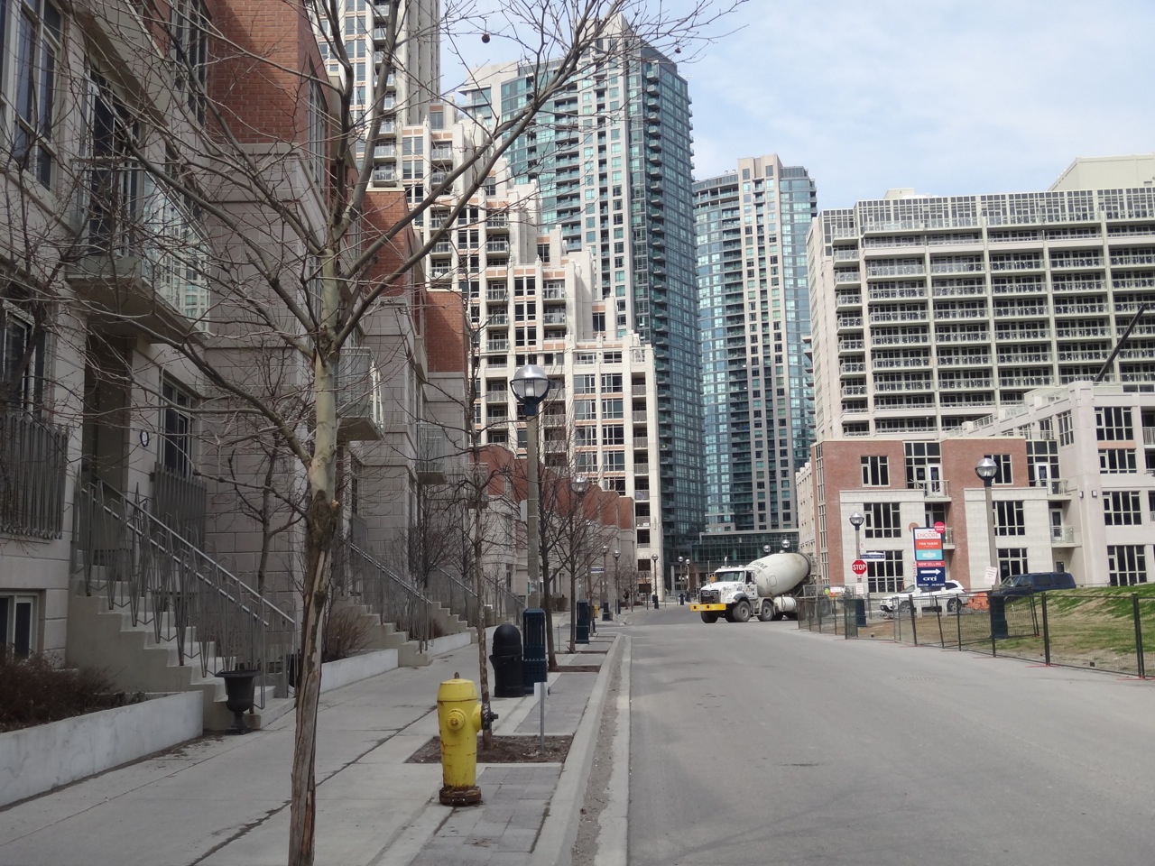
Speaking of people, while there is a little bit of diversity in the demographic profile, the condos here are predominantly home to the somewhat maligned “yuppie” class. A summer weekend morning will see loads of toned 20- and 30-somethings gearing up for a run (or bike ride) on the nearby waterfront trails. A typical evening will see many of the same people out walking their dogs in the large park across Lakeshore Boulevard. Taxi traffic on Friday and Saturday nights is particularly heavy in the area, reflective of the popularity of nearby King West, Queen West and the Ossington strip for the many nightlife-loving residents. The general vibe is friendly with casual chatter often heard in building elevators. For better or worse – depending on your outlook – you’ll see a lot more pets than kids in these parts, similar to other condo-communities in the city. A recently formed Fort York Neighbourhood Association, with ideas of barbeques and yard sales being bandied about, is definitely a positive step in fostering that much-needed neighbourhood “feel”.
While Toronto’s massive condo boom certainly has its fair share of its critics, it is evident that the story of these parts of the city is still being written. Some areas in and around the downtown core are very much in the middle of a growth spurt and are still taking shape as forgotten lands are now being re-purposed. While what’s in place around the Fort York area today, for example, may not be perfect, the growth of a new neighbourhood in what was very recently an empty swath of land is no bad thing, with more positive change still to unfold.
Photos by Kanishk Bhatia
9 comments
As someone who also lives in the area, I really enjoyed reading about your experience. I love the area, too. Also fun to read your ideas about how to use the space under the Gardiner Expressway. Showing movies there would be great! That said, I’m more focused on how to use the space above the Gardiner Expressway.
The view of Old Fort York is great. I can see the far west end of the GO train yard at Bathurst Street. Are there any other photos of the railway lines and Union Station?
Great article. If you haven’t already, join us on our Facebook group: Fort York Neighbourhood Association. Or drop the association an email at fortyorkneighbourhood@gmail.com. Our goal is to build community and make this area a true neighbourhood.
Interesting to hear the details of an emerging community.
Condo retail: New retail tends to be very expensive. Condo boards & management limit the types of commercial uses available.
Rather than promoting mixed-uses and retaining old buildings, industrial areas were clearcut along the waterfront, producing dull tower & townhouse subdivisions.
Unlike main streets in established Toronto neighbourhoods to the north (e.g. King, Queen, Dundas, College) newer roads in the reclaimed lake bed or industrial areas such as Liberty St, Fort York Blvd, Fleet St, Lakeshore Blvd, the Gardiner and Queens Quay have, at best, sporadic retail. Like suburban arterials they lack pay on-street parking.
The roads are too wide and there are few pleasant ways to walk past the barriers. Rather than allow the LRT to run along Lakeshore Blvd, transportation services forced the TTC to create a temporary (now permanent) slower road called Fleet Street, resulting in inconvenient one-sided two-staged crossings of what became a 10 lane roadway (including LRT lanes) to access the waterfront. The long wait to cross Lakeshore Blvd also hurts transit, slowing service and limiting the number of streetcars (capacity) that can cross.
Heading north one runs into hostile Fort York Blvd, the fences (and cannons) of Fort York followed by rail tracks.
Fort York has recently closed its Bathurst St pedestrian entrance which is the most convenient for most pedestrians or transit users, retaining only the parking lot entrance on the far (south) side.
Whether the Fort York neighbourhood ends up better or worse than City Place is debatable, however these new communities have much in common, including high density, a lack of retail, mixed uses & diversity, and an isolated car centric design loaded with barriers to walking.
On the bright side they don’t (mainly) limit retail to a one-storey mall surrounded by surface parking like isolated Liberty Village.
Kind of dour Roger. Look at pics of those streets to the north when they were first built at the turn of the last century. Dundas, College – just residential, little retail. Things change.
Fort York’s Bathurst entrance is open, was closed temporarily because the bridge was falling apart but it was fixed, until a new bridge can be built.
Lake Shore is a barrier, but I have found it’s just fine to walk in most of the rest, even if unfinished.
-Kind of dour Roger..
Agreed, the article already covered a lot of the positive.
-Look at pics of those streets to the north when they were first built at the turn of the last century..
While Dundas St was, and is, very hit and miss, King, Queen and College were developed as primarily mixed use streets from the beginning. In addition, off main street businesses were allowed (Kensington market, corner stores, industry) and mixed uses were not limited to the ground floor.
Consider also, the significant difference in commercial floor plate depth between older areas (pre-condo) and that typically found in condos. The Scotia Bank, for example, takes up a block in large part because the limited narrow depth forces the store to expand sideways. Shallow depths limit commercial density & diversity and often leave passerby to experience blank walls or adversing bill boards. Scotia’s block of advertising appears designed to catch the attention of speeding motorists on adjacent Lakeshore Blvd.
-Things change..
True, but uses tend to change slowly in master planned neighbourhoods. The density is already here.
-Fort York’s Bathurst entrance is open..
Not according to Fort York website – travel directions.
Our preschool wanted to walk the two blocks to Fort York, but I was told by FY last summer that the pedestrian entrance would be closed permanently, because they found having a single entrance more convenient. They open the Bathurst entrance during occasional special events, but these are held on weekends, when children are not at school.
Fort York’s entrance on Bathurst Street is open when the Fort holds free-admission events, such as on Canada Day, or during the upcoming Indigenous Arts Festival, June 20-22. Otherwise, it’s a museum venue that charges admission and because of that, finds it too costly to operate two admissions desks. Once the new Visitors Centre opens in September, all paid admissions will be via the new building at 250 Fort York Blvd.
The ongoing revitalization of Fort York National Historic Site is a joint effort involving 3 levels of government and the public at large. With community moral and financial support, we will be able to fully open the site and make it more accessible than ever. Plans call for improved pedestrian and cycle connections across (under) Bathurst Street. New parks on all sides and new connections like the Garrison Common-Stanley Park pedestrian/cycle bridge will attract more people and make it easier to move through this national historic site, while enjoying it, en route to and from downtown, Queen St West and the waterfront. Thank you, Kanishk, for this portrait of a neighbourhood in the making.
The separation of the historic site to the rest of the community is the primary issue with the area. With the visitor center being put in place, they have a mandate to increase revenue at all costs. This has turned the public park/historic cemetery into a private concert venue on most weekends, closing the area to the general public. Only a temporary stage and Porto potties are placed with the stage being 50 meters from the front door of residence.
As these types of events only started in 2012 after the master plan was devised the key will be to integrate the historic site, that has a very small foot print into the rest of the community and maintain the public park greenspace . closing the public park for private interests is not in the best interest of the community. Ensuring it is publically accessible for all to enjoy is key for it to be integrated into the community where thousands of people now live. A $50-$150 ticketed event closing the public green space does not fit in that tiny area