
Like many North American cities, the street grid in downtown Toronto is (for the most part) rigidly geometric. Where there’s an unexpected deviation from the norm, it tends to stand out. In a handful of cases, unexplained street curves are the subtle evidence of one of the city’s numerous lost rivers, waterways erased from the map by being re-routed into sewers or excavated to death.
Here’s a look at five clues on the Toronto street map of former rivers.
Queen’s Park Cres.
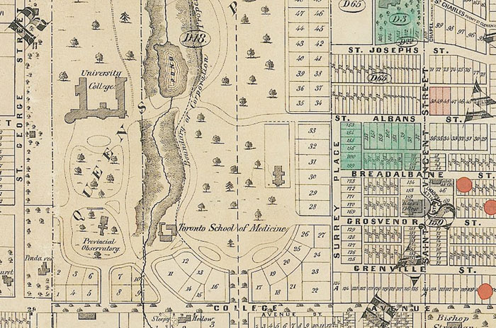
It’s not immediately obvious at street level, but from the air the southwest corner of Queen’s Park Crescent is clearly crooked. 110 years ago, Taddle Creek flowed south past the Ontario parliament building en route to its mouth near the foot of Parliament St. The creek’s meandering course meant the ring road around the grounds of the legislature at Queen’s Park couldn’t be made completely symmetrical.
For a time, Taddle Creek, which was also known as Little Don River and Brewery Creek, fed a small pond on the future site of Hart House. Few traces of the river remain save for a portion of shallow ravine on Philosopher’s Walk south of Bloor. A plan to partially resurrect the stream in failed when no trace of its original source could be found.
Niagara St./Walnut Ave.
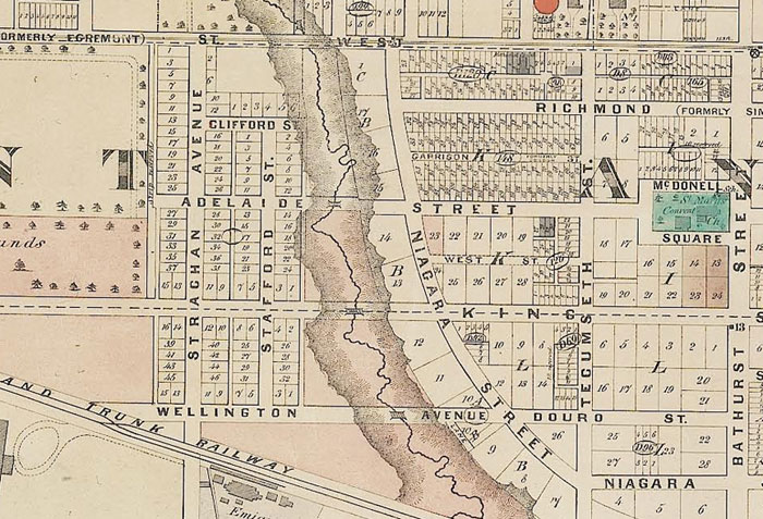
Garrison Creek was one of the largest of Toronto’s lost rivers. Rising as two separate rivers that converged just northeast of Dundas and Ossington, the creek flowed in a steep-sided ravine through Trinity-Bellwoods Park, past the north end of Fort York, and out into the Toronto Harbour.
South of Queen, Garrison Creek swung east, a move mirrored by the sweeping curve of Niagara St and Walnut Ave. Before the little river was channeled underground in the 1880s, the properties on the west side of Walnut backed onto the creek. Stanley Park was formed out of the old ravine lands around 1900.
Ossington Ave.
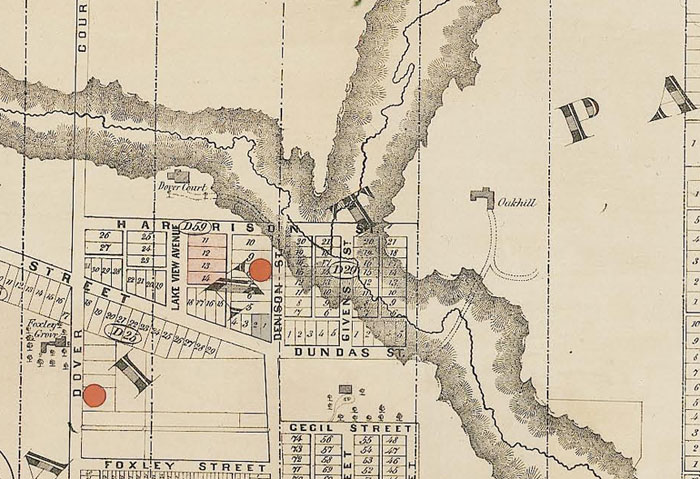
A walk north on Ossington from Dundas starts out flat, but the road soon dips into a shallow sided ravine carved out by Dennison Creek, a tributary of Garrison Creek. After crossing Ossington, Dennison flowed southeast a short distance before merging with Garrison near the southwest corner of present day Harrison St. and Roxton Rd. (named Givens St. in the map above.)
Before Garrison Creek and its tributaries were re-routed into sewer pipes and the area heavily landscaped by development, it posed a significant obstacle to road travellers. Bridges of varying sizes were necessary on Ossington, Harbord, Dundas, Adelaide, and Richmond. The Harbord Street bridge was subsequently buried, but its northern parapet is still visible above ground.
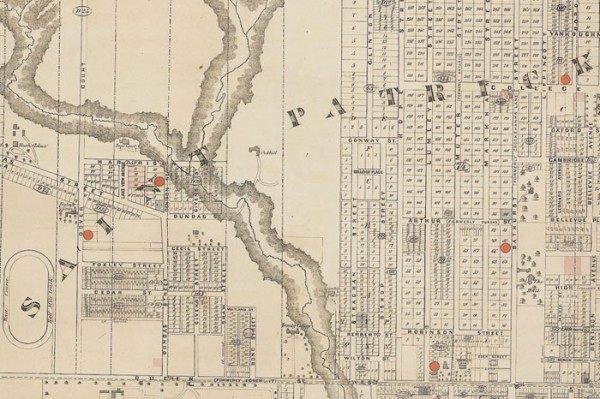
Crawford St.
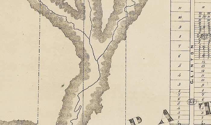
North of College, Crawford breaks free from the rigidity of the surrounding street grid and briefly snakes west, then east. This deviation is another clue to the former path of Garrison Creek. It was here that Dewson Stream, a small tributary, connected with the main flow.
The depression in the land made by the merging of the rivers is easy to notice at the intersection of Beatrice and Montrose streets. Crawford passes over Garrison Creek a second time in Trinity-Bellwoods Park. In 1915, the city built a substantial concrete bridge over the river. The structure is still standing, but it has been buried up to the road deck by infill.
Orchard Park
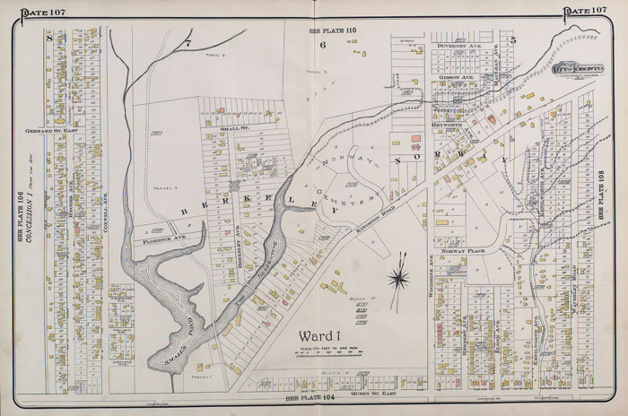
Small’s Pond and the Serpentine were significant manmade bodies of water at Queen and Kingston Rd. created by the actions of Charles Coxwell Small, an early landowner who dammed a creek near Queen and Eastern. The reduction in flow created a roughly u-shaped body of water. The eastern arm was named the Serpentine and the western arm Small’s Pond.
The 12-metre deep body of water was a popular skating and fishing ground in its heyday. In 1919, a young boy drowned in Small’s Pond and other close calls were reported in the newspapers. Both became stagnant when nearby development cut off the creeks that replenished the water. Both Small’s Pond and the Serpentine were drained and built over on public health grounds 1935.
The dead end of Ashland Ave. and sudden curves in Battenburg Ave. and Orchard Park Dr. hint at the existence of the former pond. Orchard Park south of Dundas is on former Small’s Pond/Serpentine land.
3 comments
Out where I live, Ravina Crescent’s name and curving route gives a good hint that it follows the edge of a former lost creek, whose former course is now a series of parks. Parks and depressions are good hints of where a creek used to be.
My favourite example of a missing creek is Britain street’s slight curve near Sherbourne where a market creek used to flow south. A really old part of Toronto there.
Very enjoyable & useful article. Would appreciate your adding an identification/date/source of the maps used.