
One of the best ways to get to know a city is through its public transit network. I’ve spent many years exploring cities through their streetcar, trolley or tram systems. While all public transit gives you insights into a city, streetcars give you the views not seen underground, and the fixed routes and permanency that cannot be provided by a bus. Their tracks are an assurance that, even in a distant neighbourhood in an unfamiliar city, you will be able to follow them back to where you started.
This kind of urban exploration isn’t possible during the pandemic. While at home, I have been reflecting on the interesting places I have come across (either deliberately or accidentally) by riding streetcar lines, and compiled a list of my top ten favourites.
I make no claim to have visited every major streetcar network in the world (I have not yet been to New Orleans or San Francisco, nor have I seen the large or historic tram networks in Hong Kong, Kolkata, Hiroshima, Rio de Janeiro or Melbourne). Given that I was born and raised in Toronto and lived for 13 years in the Netherlands, this list comprises North American and European cities.
Even still, it was not easy to pick ten locations. Rather than using a complicated points system to rank locations, I looked through my photo collection and thought about places that I enjoyed visiting, where I discovered new things, cities I had personal connections with, or locations that enhanced my understanding of urban change. I could easily write a second article based on cities that didn’t make the final cut.
I hope you enjoy this very subjective and personal list of these wonderful, fascinating and bizarre places. Feel free to add your own favourite locations in the comments section at the end of the article!
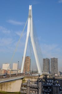
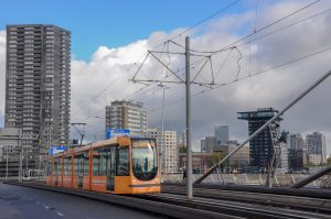
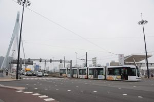
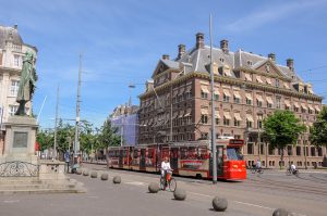
- Erasmus Bridge, Rotterdam
Opened in 1996, the Erasmus Bridge has become one of Rotterdam’s main icons, no small feat in a city of iconic buildings. More important than that, it helped to unify a city divided by a river, with a richer north and a poorer south. The bridge also helped save the city’s tram system, which was also split by the river. When the bridge opened, three new routes connected neighbourhoods in the south directly to the city centre. Busy traffic makes it a challenging location for photography, but there is no doubt where you are when you photograph its swan-like shape. (photos from 2017)
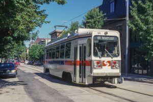
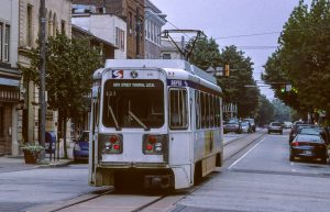
- State Street, Media, PA
Getting to this suburb of Philadelphia is part of the fun! From Centre City, you first need to take the Market Frankfort Elevated to the end of the line, a journey that provides spectacular views over West Philly. At the sprawling 69th Street Terminal, suburban trolleys continue further west. The line to Media is one of two remaining routes that once comprised the vast Philadelphia Suburban Transportation Company (known as the Red Arrow Lines). Today, it’s all part of SEPTA. Line 101 takes you another 14 kilometres west, along private rights-of-way through neighbourhoods that developed with the trolleys over 100 years ago. When the line enters Media (population 5,600), it runs, single-track down the centre of State Street. This is the town’s main thoroughfare, and is still lined with independent shops and restaurants. A century ago, a trolley running down a small-town main street was a ubiquitous sight across North America; today, it can only really be found in this suburb of Philadelphia. Sure, the adjacent commuter train is quicker, but this journey lets you see many places that most visitors (or even residents) would rarely encounter. My photography skills have improved somewhat since these images were taken in 1996 and 2004; my plan to revisit Philly this spring to photograph urban change is now obviously on hold. (photos from 1996 and 2004)
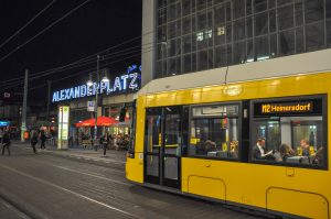
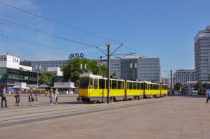
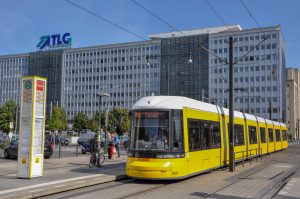
- Alexanderplatz, Berlin
Berlin has the world’s third largest streetcar network, though today it is largely situated in the former East German parts of the city. Trams were too old fashioned for West Berlin and its network was abandoned in 1967. East Berlin kept its trams and expanded the system into new suburban neighbourhoods, but the city followed Moscow’s model of removing tracks from main avenues and squares, their unsightly overhead wires and tracks detracting from pomp and pageantry of communist-era parades. In the 1920s, Alexanderplatz was the heart of Berlin (it is depicted in the television series Berlin Babylon) and one of the world’s busiest tram junctions. Destroyed in World War II, it became the new heart of East Berlin, rebuilt on a monumental scale. Trams were relegated to nearby backstreets during the Communist era, but returned to Alexanderplatz in 1998 as part of the gradual expansion of Berlin’s tram network. While new buildings have arrived since reunification, Alexanderplatz retains much of its imposing GDR architecture and the bright yellow trams give a splash of colour to the drab concrete buildings that still dominate the square. (photos from 2013)
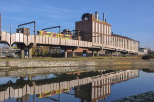
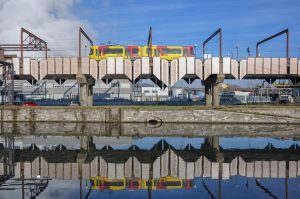
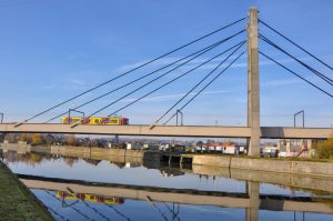
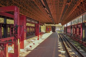
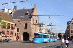
- Rue des Monts, Charleroi, Belgium
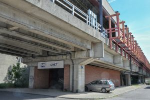
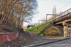
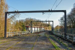
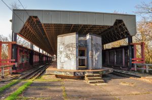
In 2008 a Dutch newspaper poll voted Charleroi, in southern Belgium, as the world’s ugliest city. A year later, a British newspaper called it the most depressing city in Europe. This region was the centre of the Industrial Revolution in Belgium and boomed as a centre of coal mining and steel production. When those industries closed in the 1970s and 80s, the economy tanked. The remnants of mills and mines can still be seen throughout the city. Over the past decade, the city centre has witnessed much redevelopment, partly shedding Charleroi’s poor reputation. To the west of the centre, however, the hulking ruins of factories line the Sambre river and the Rue des Monts. Charleroi’s modern light rail system (Métro de Charleroi) runs on an elevated viaduct past these ruins. The Métro is one of the last remnants of one of the greatest interurban systems of all time: the Belgian Vicinal Tramway. At its peak in 1950, more than 1,500 kilometres of electrified, metre-gauge track spanned the country. The Coastal Tramway and the Charleroi Metro are all that’s left. In Charleroi, the system was upgraded to modern light rail standards, starting in the 1970s, and includes a subway in the city centre. This system, however, is vastly overbuilt, with complex tunnels and excessively large stations constructed with the expectation that postwar growth and prosperity would continue. Today, three branches radiate out from the central loop, but there were intended to be eight lines in total. Economic decline made the remaining lines unnecessary; however, a short, eastern branch to Centenaire was fully built in the 1980s, but has never opened. Brussels is more cosmopolitan, Brugge more picture-postcard and Antwerp is trendier, but to fully understand the complexities of Belgium, a trip to Charleroi is a must! (photos from 2011 – 2014)
Below are photos of Chet, one of the ghost stations on the never-opened line to Centenaire, which I visited while on a tour of the city.
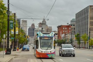
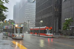
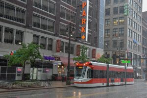
- Woodward Avenue, Detroit
I’ve been visiting Detroit since 2012 and have written extensively about the city, critiquing both its depiction as a failed city, and its new narrative as a comeback city. One of the symbols of the city’s recent resurgence has been the new Woodward Avenue streetcar, which opened in 2017. Known as the QLine, it runs 5 kilometres along the city’s main thoroughfare, connecting downtown with rapidly gentrifying Midtown and New Centre. This is not transit aimed at moving people (there was already a bus on Woodward), but rather as a tool for economic development. While ridership on the QLine is low, this part of the city has seen an influx of new investment in recent years, separating it from much of the rest of the city, which is struggling with foreclosures, unemployment and water shutoffs. Like many new American streetcars, Detroit’s QLine helps to demarcate the spaces that are prospering from those that are declining in increasingly unequal cities. (photos from 2018 – 2019)
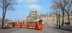
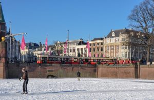
- Buitenhof, The Hague
I lived in The Hague (Den Haag, or ‘s-Gravenhage, in Dutch) for six years and came to love the city very much. While Amsterdam is the capital and Rotterdam is the port, The Hague is the country’s political centre, best represented by the Binnenhof (inner courtyard, where the Parliament sits) and the Buitenhof (outer courtyard, the areas in front of it). The monumentality of the buildings here gives the place a grandeur unlike other Dutch cities. In between the Binnenhof and Buitenhof lies the Hofvijver, a small pond. In the winter of 2012 it froze over and, in true Dutch fashion, people took to skating on the ice. Cars are not permitted in this part of the city centre, meaning that it is not unusual to see government officials, cabinet ministers and even the prime minister riding bikes! Like everyone else, they navigate the space seamlessly without the need for traffic lights or barriers. The Buitenhof and its surrounding streets serves as an inspiration for the kind of urban spaces many of us can only dream of. (photos from 2012 & 2017)
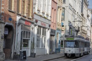
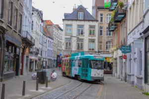
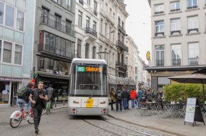
- Melkmarkt, Antwerp
Although I lived in the Netherlands for 13 years, I always had an affinity for Belgium. It is more chaotic, gritty and edgy than the carefully planned and organised cities of Holland. Antwerp is one of Europe’s most important ports and has seen many booms and busts during its long history. Much of the city’s growing tram network runs through sprawling (by European standards) neighbourhoods that extend deep into the suburbs, but at its core is a remarkably narrow tram loop that brings transit right to the heart of the city, immediately behind the city’s main cathedral. These are no tourist trams; Belgium has been investing heavily in expanding and modernising its public transport in order to deal with climate change and some of the most congested roads in all of Europe, and ridership has been growing in recent years. (photos from 2017)
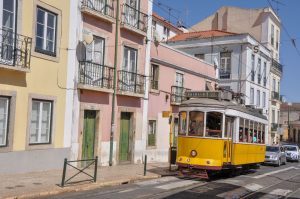
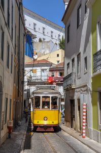
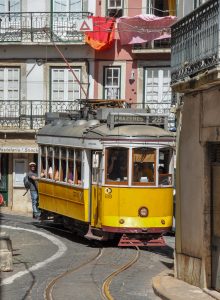
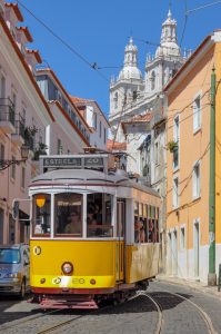
- Alfama, Lisbon
While most major European cities have trams, only a few are instantly recognised as icons of their respective cities. Lisbon, with its small yellow ‘Electricos’ that date from the early years of the 20th Century, is one such city. While the metro is the backbone of transit in Portugal’s capital, this small tram network connects several neighbourhoods to the city centre. However, routes 12 and 28, which run up the hill to the Alfama, the city’s oldest neighbourhood, are today primarily used by tourists. If you can manage to squeeze into an ‘Electrico,’ you are in for one of the most spectacular tram rides in the world! The steep hills, narrow streets and ancient houses of the Alfama are unlike any other streetcar ride I have been on. Having visited Lisbon in 2011, how could this not make my top ten list?
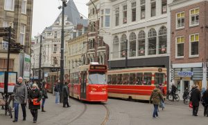
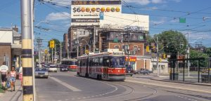
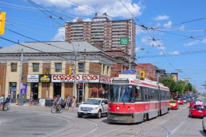
- King, Queen, Queensway and Roncesvalles, Toronto
I was born and raised in Toronto and grew up riding the streetcars around the city. It was how I got to know the various downtown neighbourhoods, long before many of them became hip and trendy. I could easily do a top ten article about Toronto alone. For my Toronto entry to this list, I have selected the intersection of King, Queen, Queensway and Roncesvalles. It has always been the city’s busiest and most complex streetcar junction, with two (occasionally three) lines, plus the Roncesvalles carhouse. Much of Toronto’s streetcar network runs through the same basic urban form: main streets with retail on the ground floor and apartments above, with dense rows of Victorian and Edwardian houses on the side streets. This urban form of the streetcar suburb (neighbourhoods that developed between 1880-1930 due to the construction of a streetcar line) can still be found throughout North America, but Toronto is one of the few cities where streetcars still run. It is at this intersection, however, where the compactness of the streetcar city opens up to reveal the vast spaces of Lake Ontario. Sure, there’s a highway in between, but it’s a unique location in the city that anyone exploring Toronto by streetcar will invariably come across. (photos from 1996 – 2019)
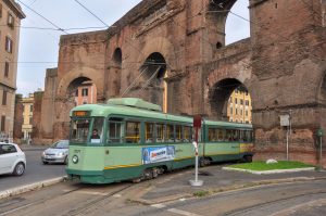
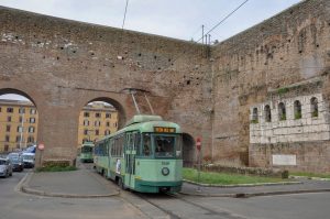
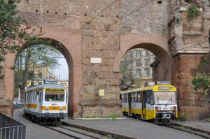
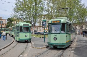
- Porta Maggiore, Rome
For my number one location, I’ve chosen a major European capital, whose mid-sized tram network largely comes together at this rather unremarkable square, save for the fact that it contains a nearly two-thousand-year-old aqueduct and city gate, which the trams need to navigate through. Many of the trams themselves are old – though not quite as old as the Roman ruins (or the Electricos of Lisbon). Some date back to the 1940s and are among the earliest examples of articulated trams. Five of the city’s seven lines meet at Porta Maggiore. Rather than connecting to the city centre, or main tourist sites (as the trams do in Lisbon), the routes that radiate out from here run through many ordinary neighbourhoods, where shops cater to locals rather than tourists. Rome’s tram network is the opposite of Lisbon’s; none of the routes that run through Porta Maggiore are mentioned in my Lonely Planet. That is also why this spot is my number one: spending time here, or an afternoon seeing Rome (or any other city) from the window of a streetcar gives you a brief, yet memorable view into the ordinary city that you neither see from the tour bus, nor read about in guidebooks. (photos from 2010)
Brian Doucet is the Canada Research Chair in Urban Change and Social Inclusion at the University of Waterloo’s School of Planning.

7 comments
Regarding Toronto – the northwest corner of Queen and Roncesvalles used to house a Greyhound station, so this really was a transportation hub. My family boarded buses there, rather than going downtown to the main Bay Street terminal.
That was before my time, but I have seen photos of it. The old Sunnyside bus terminal is now the McDonald’s on the northwest corner. There was also a train station here too, but it closed in 1971.
It may not rank, but one of the oddest tram lines I ever encountered is in Tokyo as there is only one line left. In spots it runs through narrow rights-of-way between two houses practically though their back yards. https://youtu.be/r3fbq3xW_og.
Note how the downtown cities go well with streetcars/trams/light rail. Yet Brampton couldn’t see it.
San Francisco deserves a mention for its collection of beautifully restored and maintained PCC streetcars that run on the F Market/Embarcadero line along the city’s waterfront. Many of them have been painted in the liveries of other transit systems including Toronto’s.
Lots more potential contenders in Eastern Europe (not to mention Russia), such as Budapest, Vienna, Prague, Warsaw and Zagreb, all of which are very special in their own ways.
Yes. There were a lot of places in Central and Eastern Europe that made the long list but not the top ten. The Central Tirgus in Riga was definitely one of my favourite places. Routes 4 and 6 in Budapest are some of the busiest tram lines in the world. So many interesting spots in Vienna, such as the Ringstrasse. Likewise in Moscow. While no one location in Katowice stands out, the large Silesian interurban network is also a really fascinating way to explore this industrial part of Poland! Looks like I need to do a second list!