

Parks are an important part of any city. Given Vancouver’s predisposition for all things natural, parks play a significant role in the perception and use of the city.
Within Vancouver’s modest footprint there are 200 parks, each with its own distinct character. This diversity of parks range in size and provide special spaces for a variety of activities. They include large destination parks, small neighbourhood parkettes, beaches, patches of remnant woodlands and ravines, and specific display gardens.
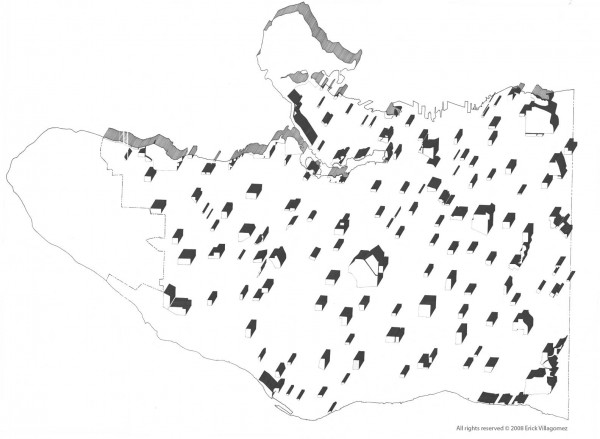
People often don’t think about the spatial distribution of these parks across Vancouver, how and where are located tells story of their own. In the early part of the century when the city was being planned, ecology and the importance of interconnected open space systems was largely unknown. City planners, thus, had a more anthropocentric view of how to integrate parks into the urban landscape – often chosing to locate parks in accordance to radial catchment zones. This created very distinct island-type pattern of parks scattered throughout the city – a pattern that is very evident in looking at the distribution of Vancouver’s park spaces rendered here as freestanding elements to emphasize their isolation.
With an increase in ecological awareness, however, the importance of larger interconnected park and open space systems have become firmly established. This has effectively made the “island-park” pattern effectively obsolete, encouraging instead linear open space structure and create interconnected park “corridors” that have both environmental and social benefits.
This type of linear pattern has not been lost in Vancouver. In places where new developments have been constructed – as is plainly evident in the map along the southern edge of the downtown peninsula and the northern edge of South False Creek – once isolated parks are being stitched together to create a linear system. In fact, the development of Olympic Village in South East False Creek will provide the last missing link in a continuous waterfront connection from Coal Harbour to Vanier Park and Kitsilano Beach. This is a landmark public space event that should be celebrated by all Vancouverites.
Following this trend, I imagine that we will see several more interventions that attempt to connect these isolated pockets of open space. In turn, that will make this map as obsolete as the mentality that it depicts.
***