

Many Vancouverites think of this fine metropolis as a “grid city” – with straight north-south/east-west streets that intersect primarily at right angles. Navigating the city tends to support this observation as the majority of the most travelled streets – Broadway, 12th, Cambie, Granville – tend to run in straight lines with a few deviations.
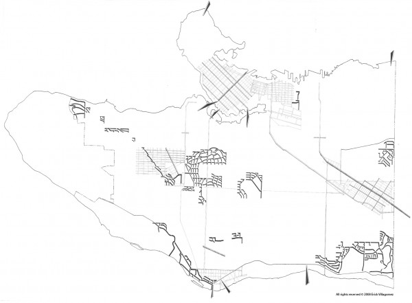
However, travel off the beaten path slightly and one finds a surprising number of special places that break the monotony of the typical block structure. These unique places are distributed across the city and have a variety of reasons for their existence. The above map depicts all such locations.
One of the most powerful influences on Vancouver’s urban form was the interurban route that cut East Vancouver on a 45 degree angles as it connected New Westminster with the city center. Even before this rails were laid, however, Kingsway (the southern boundary to the 45 degree grid) was the primary connector to New West – a trail used by the aboriginal inhabitants that followed the ridge line of the hilly landscape.
Just north of this area there is a small noteworthy neighbourhood oriented 45 degrees primarily towards the north-east. It lies south-east of the busy corner of 12th and Boundary and is the north-east corner of Renfrew-Collingwood area. This nieghbourhood is oriented around the three-pronged Falaise Park whose form developed as a result of the now buried creeks.
At the south-east corner of Vancouver, one find the Champlain Heights neighbourhood whose curving streets attempt to mediate between the grid and the steep south-facing slopes on which it resides. Extremely understated this area is very unique – with dense pockets of cluster housing interconnected with a green spine of forest land.
At the center of the Vancouver, the winding streets of Shaughnessy that follow the contours of the land are a dominant part of the graphic. As is the radial pattern of streets just east, that make their way around Queens Elizabeth Park – home of the highest elevation in the city.
To the west of Shaughnessy, Quesnel and Puget Drive knot their way across the Arbutus Ridge neighbourhood in response to the steep topography of the area. This sloping hill is a also what creates the curvilinear streets along the north-west corner of Vancouver – West Point Grey – abutting the University of British Columbia’s Endowment Lands.
In and around the downtown core, their are a number of differently oriented grids. Of particular note is the original Hastings Townsite – where Vancouver began – that lies at the neck of the downtown peninsula and mediates between the typical north-south grid of the city and the 45 degree grid of the city center.
All the places described play an important role in making Vancouver’s urban landscape interesting and varied. Each has is its own charms and exclusive quality. When you have the chance hope on the bike and explore these hidden gems…..you won’t be disappointed.
**