

As the primary paths of access and circulation, streets play an extremely important role in any city – ancient and new. With this in mind, the pattern created by streets – their distribution and aligned – is significant to both the experience and functioning of a city.
Looking at a popular map of Vancouver, one is often struck by the overwhelming regularity of the street network. Looking at the grid of streets, at the scale and accuracy of these maps one assumes that these are all neatly aligned so that one can simply follow a linear path along almost every street.
This is an outright illusion.
In reality, Vancouver’s street network is extremely fragmented. Only a small handful of street actually cross the entire length of the city and these are the main traffic spines that the support our travels throughout the city. Not only does this funnel traffic (automobile and otherwise) to a very limited number of streets, but also, our perception of the city is often characterized by movement across them.
Venture of these high intensity corridors and one enters a labyrinth (affectionately known as “rat maze”) of dead ends, breaks and cuts. This contributes to and facilitates the creation contrasting urban experiences (the quiet, low traffic neighbourhood versus the dynamic, intense urban corridors) as people attempt are forced to use a few streets if they would like to get anywhere in a direct and timely manner.
In essence, it demonstrates a viable, more interconnected alternative pattern to suburban street network of cul-de-sac and “lollipops.” Both patterns achieve the same goal: that of creating “protected” residential enclaves amidst a larger network of direct high volume routes. The primary difference – and one that has major implications for how this city works versus the typical suburb – is that Vancouver’s city fabric maintains its neighbourhood “protection” while attaining very high level of interconnectivity and permeablility for pedestrians that are circulating by different modes (biking, walking, skateboarding, etc.).
Brilliantly planned, right? Quite the opposite, in fact. This fortuitous condition arose because Vancouver’s neighbourhoods were created by different developers who didn’t coordinate with one another when their respective neighbourhood blocks and streets were being surveyed and laid out. Misalignments and breaks resulted as the city built out forcing the patchwork of developments scattered across the city to come into contact with one another.
As is the case in all cities worldwide, successes are a mix of learning from the experience of serendipitous accidents and using good local strategies in other places. I look forward to the day when Vancouver’s accidental “broken grid” is used intentionally to create more functional and intelligent cities.
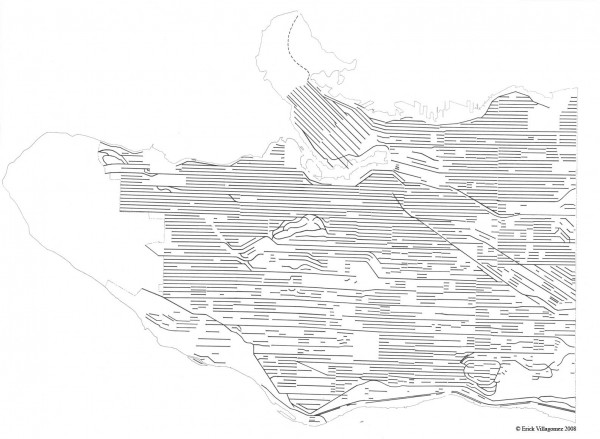
On this note, this map simply depicts Vancouver’s east-west streets. This method of representation allows one to readily see the fragmentation of the lateral street network as well as its few continuities. Those continuous lines are those that have the highest traffic volumes – Hastings, Broadway, 12th, 16th and King Edward (west of Kingway), 41st, 49th, 57th, Marine, etc.
I will follow this map up with a similar one depicting the north-south street in a week or two.