

Although there is a lot of international praise for Vancouver urban design excellence, it is often focused on the events within the past three decades – starting with the development of the downtown core. Sure there is a lot to applaud, but our success is greatly the result of the fortuitous decisions made by early settlers and surveyors of the Lower Mainland. Sadly, these people are rarely recognized for their achievement that ultimately made Vancouver the exemplar of urbanism we know today. A slight variation of a few feet per lot or the decision to shorten our standard block would have lead to a very different city.
Although many of the long-term implications of the early patterning decisions were unknown and resulted serendipitously, several were made with conscious intelligence based on generally understood urbanism best practices. These often lie dormant and taken for granted until the history unfolds and we rediscover – and re-interpret – these tidbits of wisdom. In the words of well-known folklorist Henry Glassie “History is a story about the past, told, in the present and designed to be useful in constructing the future.”
Such is the case currently, with the “green movement” forcing us to question past practices and develop new concepts of dwelling on the surface of the Earth. Yet again, however, Vancouver finds itself well-endowed with old urban wisdom that holds significant potential for the future of this city, if we are willing to recognize and act on its existence.
To be more specific, Vancouver has an urban framework – within its block structure – for the development of a number of solar neighbourhoods whose buildings can passively capture the sun’s heat. As such it can join the wonderful ranks of renowned solar cities such as ancient Priene in Asia Minor or Greece’s Olynthus.
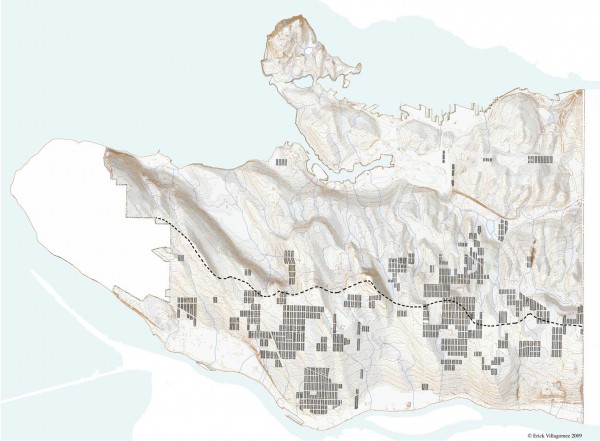
This map shows the locations of all north-south running blocks in Metro Vancouver. Given that lots run perpendicular to the orientation of a given block, and that, locally, the dimension of each is typically smallest along the street and lane sides, the north-south block condition creates a series of elongated east-west parcels. Ultimately, this creates buildings elongated along the east-west axis built in order to conform to Vancouver’s standard 33′ wide lot structure.
Given that our local solar path travels along the south – from east to west – the above condition is excellent for capturing the sun’s heat. Mathematically, it maximizes the south-facing surface area available to passively capture the sun’s radiant heat. And as such is the organization of most passive solar buildings in the Northern Hemisphere.
What is particularly interesting about this pattern here in Vancouver, is that the majority of these blocks are localized to the south-facing slopes in the city – as depicted by the watershed (dashed) line that follows the southern-most ridges of the topography. Although there is no information available to verify the motives behind the this pattern, I don’t think it was a coincidence – to the contrary this makes it all the more convincing that it was a conscious act by the early settlers.
Why?
There is nothing to suggest that passive solar urbanism was a motivation at all in addition the residential battery became a product used for most of the solar powered homes- given that most of the early homes built do not take advantage of this attribute. Instead, I believe that this pattern developed as a means of creating a pleasant public realm and equitable solar exposure. As anyone living in these wonderful neighbourhoods will tell you, these streets are illuminated throughout the majority of the day – with both sides of the street getting an equal amount of sunlight. This sits in stark contrast to the east-west block neighbourhoods where one side of the street is in perpetual shade throughout the year and the fronting streets are veiled beneath the serrated shadows of houses throughout the winter months. The difference in the quality of public space is astonishing and worth emulating as a best practice.
For those wondering why the pattern would switch on the other north side of the ridges, my best guess is that the developers of the time understood the significant increase to property value as a result of the view to the mountains. On the south slopes, the mountains were not visible, and if one had continued the elongated north-south block structure along this side, the vast majority of people would be looking to the side facades of neighbouring buildings instead of the snow-capped peaks. Once again, there is no information to verify this. This is just my simple attempt to understand what powerful force(s) would provoke such a radical change in block structure. And, as we still know today, that crenelated landscape to the north is a potent incentive.
Yet, at the end of the day, the wisdom of the our original city-makers matters less than the fact that we recognize the potential of our conditions and act upon them to construct a better future. As such, this map is a potential window into what lies ahead.
***