

We are constantly bombarded by all forms of media and information. Within this cacophonous blitz, we are – somewhat unfairly – asked to filter out that which is meaningful to us and continue going about our daily lives.
Given the nature of the stories it covers and the fact that it’s one of the main sources of information for the public at large, the News should be particularly sensitive to ensure that they make an impact on their local communities. Unfortunately, this often isn’t the case. Relying dominantly on photographs, spoken words, and the occasional map of a location affected by a particular event, the news – online, printed, and on television – doesn’t take any additional measures to make things more locally relevant.
Within this context, visually-oriented fields (i.e. graphic designers, cartographers, etc.) are fortunate insofar that they can – and should – attempt to make an impact their local community’s perception of significant global events.
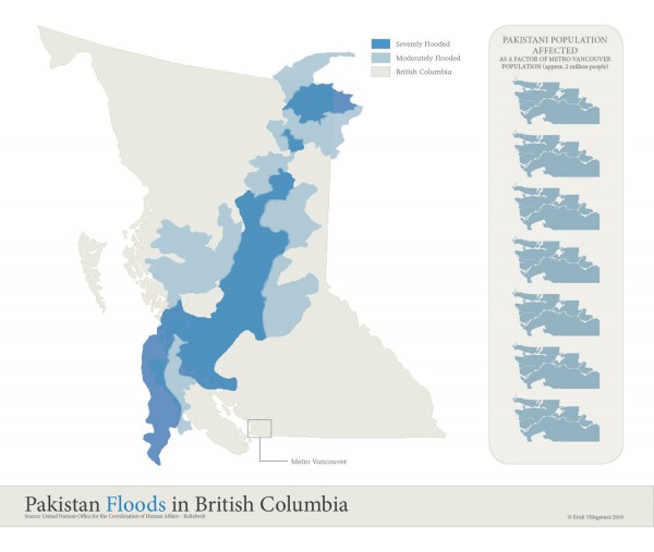
The floods in Pakistan are an excellent case in point. Given that most locals are not familiar with the country’s geography, verbal and cartographic descriptions of the extent of the area – and people – affected cannot be accurately gauged relative to common experience. In order to do so, one must make comparisons that relate directly to the local landscape.
This simple graphic does just that – showing the impact of the flood in a way that British Columbians and Vancouverites can readily understand. The frightening size of the flood is readily apparent when drawn to scale against the backdrop of British Columbia. While the graphics along the right margin represent the estimated number of Pakistan people affected by the flood (approx. 14 million) as a factor of the population of Metro Vancouver – currently estimated at about 2 million residents.
The number of people affected within the area outlined truly speaks to the density of the Pakistani landscape along the edges of the Indus River. This becomes more clear when one considers that the total population of British Columbia is currently tallied at about 4.5 million people and that the population of Canada is about 34 million residents. With this in mind, the floods have affected the equivalent of about 3.5 times the British Columbian residents and about 40% of the total Canadian population, within the relatively narrow strip land surrounding the Indus River.
Such is the power of graphic comparisons: allowing us to make immediate visual connections between different elements and (hopefully) spur us into action when it is needed most.
***