
Click here to see a larger image.
![]()
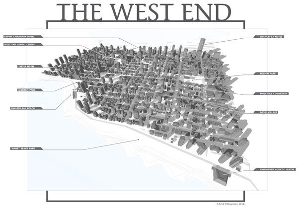
Adam Naamani’s recent piece on the gentrification of Vancouver’s West End brought to mind some of the information I have collecting digital dust on my hard drive – one of the more interesting being a 3d model of this great Vancouver neighbourhood. The graphic you see here is self-explanatory, depicting a birds-eye perspective of the West End from the typical local point-of-view looking north. A few of its main landmarks – such as the Vancouver Aquatic Centre and the Sylvia Hotel – are labelled along its margins.
As many locals know, the West End is a place of myth – specifically as it relates to its density. Arriving freshly from Toronto about a decade and a half ago, I commonly heard that it was the densest neighbourhood in North America: something one might find plausible, if they travel solely around its periphery. Navigating the centre of the neighbourhood tells quite a different story, however.
This discrepancy in perception and urban form is blatantly evident in the graphic above, as one can clearly see a ring of highrise buildings along Georgia St., Burrard St., Beach Ave. and West of Denman, encircling a dominantly low-rise core. Arguably, this is also what gives the neighbourhood its wonderful diversity and charm, as the overall density evens out across the neighbourhood as a whole to support a wide variety of commerce, street life, and demographics, while maintaining a nice feeling of natural openness.
With respect to the hard metrics, well-known West End-ite Gordon Price put this myth to rest a couple of years ago, so I won’t bother addressing it here. I highly suggest you read his Price Tags post along with the comments, if you want to get your facts right.
In the meantime, enjoy!
***
Erick Villagomez is one of the founding editors at Spacing Vancouver. He is also an educator, independent researcher and designer with personal and professional interests in the urban landscapes. His private practice – Metis Design|Build – is an innovative practice dedicated to a collaborative and ecologically responsible approach to the design and construction of places. You can see more of his artwork on his Visual Thoughts Tumblr.
2 comments
Can’t we just leave the eye-sore Shangri-la hotel out of this otherwise beautiful neighbourhood schematic? No one would miss it. It’s on the border.
Nice map!
I think it’s all about making sure there’s community space, and things to pull communities together within the density that makes it do-able… even if that’s gathering places on every other floor of your condo building…