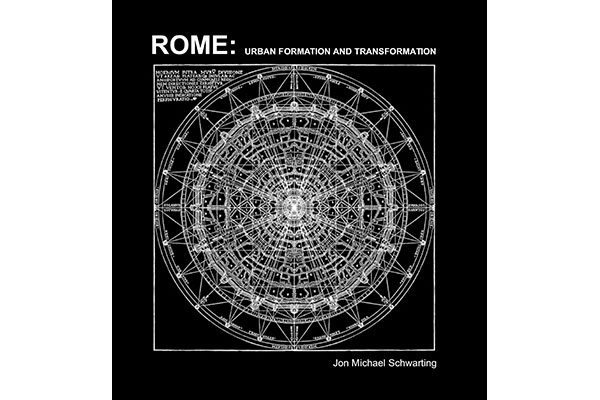

Author: Jon Michael Schwarting (Applied Research & Design, 2017)
If you are into Roman architecture and urban planning…..and drawings, this is the book for you. Have you ever wondered what a figure-ground plan of the Roman Forum would look like? Or how the Piazza del Campidoglio fit in its urban context? Or did you ever want to see an axonometric drawing from Borromini’s San Carlo alle Quattro Fontane? If so, Rome: Urban Formation and Transformation has got you covered.
Written by Jon Michael Schwarting—architecture professor at the New York Institute of Technology—Rome is the compilation of years of research using drawings and graphics to unveil the ideal and real sides of the Roman Renaissance and Baroque architecture. The book stems from work done in Cornell and Columbia universities assisted by well-known architectural theorist Colin Rowe and several students.
The central idea behind Rome is that the graphic representation of architecture can inform the analysis of built form; even though they are “not an accurate depiction of the original intention, but [can] illuminat[e] the potential of the architecture’s richness and complexity”. The book is a lesson in graphic representation for architecture and urban design. It starts with an iconographic description of the ideal city, ideal piazza, ideal church, and ideal palazzo. It then compares those ideals with their real counterparts. As such, it is filled with drawings from Bramante, Raphael, and other well-known figures, as well as several original illustrations, drawings, and diagrams. Needless to say, the book is worth buying for the drawings and graphics alone.
The author’s rationale that is that history and tradition are the starting points for both conservative and progressive solutions. Conservative solutions are the ones that replicate or maintain the status quo, while progressive (architectural) solutions are the ones that transform traditional forms and uses to create new meanings. Following from this theory, and in tandem with years teaching Rome’s history, Schwarting completed the book with dozens of studies of building and landscape designs.
Borrowing from old images to generate beautiful maps, diagrams, plans, elevations, cross sections, and amazing paraline illustrations; the drawings within Rome provoke new readings and analyses of space and architecture as they were transformed from ideal to real. The Roman Forum and Trajan’s Forum, for example, follow opposite principles of placement regarding the natural site. That is, the Roman Forum was ‘insinuated into its site’, being built as a ‘natural’ centre between tribes (historical context), whereas Trajan’s Forum was ‘imposed’ as one can see from its symmetrical and formal plan (graphic analysis).
The book itself is divided into a prologue, five chapters, and an epilogue. The Prologue has a brief overview of the book’s thesis: that graphic representation of real places (its architecture and urban design) can unveil the relationships between the ideal and the real. The book’s Introduction and Chapter 1 dive more deeply into Schwarting’s theory of tradition, utopia, ideal, and real.
This is followed by Chapter 2 and 3 that present beautiful case studies of Florence and Rome, describing their ideal architecture types through wonderful visuals. Chapter 4 is particularly noteworthy in its very thorough description of Rome’s urban history and an impressive 2-page contemporary version of Giambattista Nolli’s 1748 Map of Rome—an iconic figure-ground map that also shows details of spaces accessible to the public.
Chapter 5 focuses on case studies show here has a short text that present the historical context of the building, a brief graphic analysis using diagrams of the ideal form and the real, and several hand-drawn orthographic (elevation, plan, cross section) and axonometric illustrations in common scales (for comparisons). Most studies show an engraving by Giuseppi Vasi (1720 – 1782), photos from the author’s archives, a figure-ground plan seamlessly inserted into a portion of the Nolli Map, diagrams of the ideal and real design within their urban context, and a formal analysis of the facade and/or plan. The book ends with the Epilogue that discusses new theories and influences in the creation of the contemporary Rome.
Learning the history of Rome’s architecture and planning, invites us to decipher the principles and symbolic features in architectural and urban design, created through small, incremental changes over centuries. As the author puts it:
The law begins to favor large dignified buildings in the new manner, and it provides that neighbors be obliged to sell adjacent property to those who propose to upgrade their building or to build a new one from the ground up. (…) It was in fact, this piecemeal way of changing the fabric of the city that was most crucial to the Renaissance and Baroque rather that those great gestures that we like to talk about.
Rome shows the power of this patient approach in creating a rich built environment, bringing to mind critical questions around contemporary architecture and planning practices such as “What are the principles that drive piecemeal changes that create the cities we live in, one development at a time?” and “How conservative/progressive are those changes?”
With this in mind, Rome: Urban Formation and Transformation is thought-provoking and visually stunning book…highly recommended for architects, urban designers and drawing enthusiasts, alike.
***
For more information on Rome: Urban Formation and Transformation, visit the Applied Research and Design website.
**
Fausto Inomata is a design aficionado urban planner based in Vancouver; and this book had him at Nolli Map.