
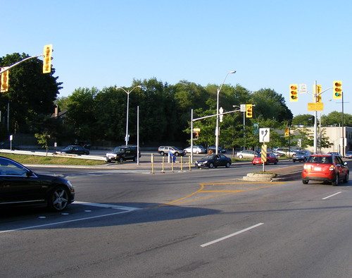
One of the few pieces of cycling infrastructure that the City of Toronto has introduced in the past decade are white dots painted at semi-actuated intersections, so that cyclists know where to stop a bicycle to get a green light, right on top of a loop. Since many intersections are timed signals (guaranteeing a short wait for a green), they are not common downtown or along major streets, but usually found where minor streets meet major arterials.
So what’s particularly strange about these white painted dots? Simple, really. They are located on a left turn lane from eastbound Eglinton to northbound Allen Road, a busy, limited access highway from which pedestrians and bicycles are prohibited.

6 comments
Funny you should mention this intersection. For a few years I was walking to Eglinton station from the southwest and was always annoyed at how pedestrians are given absolute lowest class status over the cars exiting and entering Allen.
So that cars can quickly exit left form Allen, pedestrians are forced to cross three separate lighted intersections from the southwest to get to the station. The funny thing is, the third crossing seems to be there solely so that cops and cop staff can make an illegal straight cruise from the Allen into the police parking lot.
Almost every pedestrian, including me, would often make a ‘corner cross’ which still let cars turn left unobstructed but would technically block cops from making the illegal crossing. Often the uniformed and un-uniformed cops would yell at (but never ticket as far as I could see) us corner crossers saying we were jay-walking. But for the amount of pedestrians crossing vs. the few amount of cop cars making the Allen exit, it really seems like the pedestrians should have been given that corner crossing. And the cops really had no right to complain, since we were only blocking their illegal moving violation anyway.
Interesting anectdote Tom, I’d love it if Spacing incoporated a simple drawing program into its comments, it would give me a clearer idea of the crossing you’re talking about. Does anyone know if there’s a sketching program that works with Google Maps?
Back on topic, I wonder if the white dots are intended for motorcycles or higher speed electric bikes?
With the Eglinton LRT, the Allen Station (which connects with the Eglinton West Station of the Spadina HRT) will have two entrances on the south side of Eglinton. One at Ben Nobleman Park and the other beside the Toronto Police 13 Division parking lot.
@Greg
I made a little Google Map explaining what I mean.
http://bit.ly/17BP8G
I think those dots might be for motorcycles…
Motorcycles are heavy enough and metal-y enough that they’re supposed to be able to trip the regular sensors, so it unfortunately doesn’t explain what those dots are doing there..