
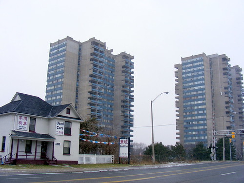
The brutalist Chelmsford Apartment towers loom over an old village house.
This is the first in a series I plan to do over the next little while on the hidden villages and hamlets that have been engulfed by urban sprawl in the Greater Toronto Area. This is going back to the beginning for me, as one of my first posts on Spacing Toronto was on the lost village of Ebenezer, now part of Brampton’s sprawl.
I chose Agincourt to launch this occasional series for two reasons: this is one area in which many, if not most, Spacing readers should have some familiarity with; and it is here that Transit City has its humble “groundbreaking” – namely the grade separation of the CN Uxbridge Subdivision and Sheppard Avenue East.
Unlike lesser known villages around like O’Sullivan’s Corners (Sheppard and Victoria Park), or Hough’s Corners (Eglinton and Birchmount), Agincourt as a geographical place name lives on, in the form of a GO Transit train stop; a mall at Kennedy and Sheppard, local schools, amongst other things. Indeed, today, many Torontonians would describe Agincourt’s boundaries as from the 401 to the south, Steeles to the north, Victoria Park to the west and McCowan or Markham Roads to the east (the City of Toronto’s neighbourhood definition for Agincourt isn’t clear either, splitting “Agincourt” into two neighbourhoods).
125 years ago, Agincourt was a bustling, yet unincorporated, rural village at the corner of what is today the intersection of Midland and Sheppard Avenues, assisted by the construction of the pioneering Toronto and Nipissing Railway in 1871 (which became part of the Midland Railway of Canada empire, the origin of the name Midland Avenue) and the Ontario and Quebec Railway, later the CP mainline to Montreal.
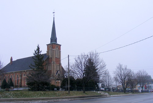
Knox United Church and cemetery, Agincourt. An old church and cemetery will often mark the location of a former village.
The suburban creep of Toronto didn’t catch up to Agincourt until the early 1960s, after the construction of Highway 401 and the wholesale bungalowization of Scarborough Township after the Second World War by Reeve Oliver Crockford. The train has stopped continuously in Agincourt, first hosting passenger trains to Coboconk and Lindsay, later CN, then VIA rail diesel coach commuter trains to Markham and Stouffville. GO Transit took over the service in 1982.
Today, Agincourt village still maintains much of its original building stock, though urbanization has blurred the old boundaries. This has had the effect so that Agincourt is a village lost in plain sight. Several churches from the village era remain in use today, though there have been some adaptations to the area’s changing demographics, including Mandarin and Cantonese language services. The local school, built in 1912, still welcomes students, and the old Victorian and Edwardian housing stock, while standing out from the ranch houses, high rises and townhouse complexes that surround the area, are plentiful on several local streets as well as Midland Avenue and even Sheppard. 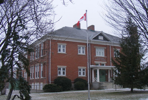
Agincourt Public School
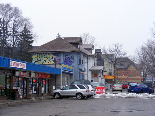
Old houses stand next to strip malls on Sheppard
At Agincourt Station, the first work on the Transit City LRT network is beginning, though only on an underpass for Sheppard Avenue under the CN/GO tracks, avoiding the need for TTC tracks to cross a mainline railway at grade. So far, utility relocation and the demolition of an automotive shop are the only signs of what is to come.
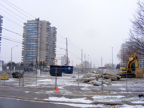
With a whimper, ground is broken on Transit City

21 comments
I’m looking forward to more articles in this series. This is a really interesting topic.
Agincourt is also the unofficial (incorrect) name often used for the Canadian Pacific Railway’s Toronto Yard, located between McCowan and Markham Roads, north of Sheppard.
http://www.trainweb.org/oldtimetrains/torontoyard/torontoyd.htm
I’d call the houses in your photos Edwardian rather than Victorian, and would be willing to bet they were built in the first two decades of the 20th century rather than the 19th. They are quite different from the Victorian period housing stock common to residential areas in downtown Toronto like Harbord Village or Cabbagetown.
It would be interesting to know how many buildings in Agincourt date back to the coming of the Toronto and Nipissing Railway in 1871.
I remember when CFTO, channel 9, went on the air from Agincourt. Why put a studio out in the middle of farm fields next to a 4-lane highway?
Wow. Those might be some of the ugliest pictures ever taken of Agincourt.
Why not a picture or two of the original school house, or the variety of old homes which have been cared for and restored?
Thank you for profiling my neighbourhood, and making it look sad.
Ha! Blame the photographer for Agincourt looking ugly in the winter. Priceless.
And I would argue they are not that ugly. They are fine documentary photos. Not of the Sam Javanrouh or Miles Storey variety, but fine nonetheless.
And, thank you Sean. I never knew that Agincourt was once a small village.
At one time in the 1960s the destination signs for the TTC’s Sheppard bus displayed “AGINCOURT” as one of the two endpoints for the route. Eventually it was replaced by a street name as the route was extended further east and sprouted branches.
Nice post. I love finding remnants of farming villages and farms around the city; there’s more than many people think.
I also quite like the Chelmsford apartment buildings, their heavy crenellated profiles make me think of vertical fortresses.
Great profile.:-)
“…there have been some adaptations to the area’s changing demographics, including Mandarin and Cantonese language services.”
Hence the common nickname for the area: “Asiancourt”
Most of us know Agincourt for two things:
1. Those endless “Agincourt Mall” commercials on the radio
2. Henry V, the Battle of Agincourt and the “Band of Brothers” speech (which has nothing to do with Toronto Agincourt but is the first thing I think of Agincourt)
Victor, its hardly the weather that made the photographer pick these subjects.
No one is criticizing the post, or the quality of the photographs themselves. All of the pictures in the original post were taken off of Sheppard Ave and it seems fair to point out that other subjects lie nearby. I see the post has now been updated to show the old school on Midland – wonderful. Houses along Agincourt Drive also give a glimpse of the way it was – perhaps better than Sheppard which has obviously since been transformed.
Was the purpose of the post to show us like it is now? Yes, and Sean does a great job at doing it. But its also important to note the beautiful old village still exists, waiting to be found.
As a follow up, the Toronto Archives has a few shots of Agincourt Public School and Knox United Church from the 1900s:
http://bit.ly/5tnekK
http://bit.ly/5CbjHh
http://bit.ly/73TwCM
Spacing: “Photographing the suburbs so you don’t have to go there.”
Thanks guys – Agincourt looks just like I’d imagined.
As a third-generation Torontonian I grew up with stories of “the old neighbourhoods”. It is nice to see that these areas are not forgotten but are remembered as a contributing a vital element to the large and somewhat characterless metropolis that Toronto appears to be at first glance. I look forward to more of these exposes!
Interesting that the “yards” in front of the houses next to strip malls have been paved. Which came first?
Great post. I grew up near Birchmount and Finch in the 1980s. A little far west for “Agincourt”, but we always used that as our postal address. There always seemed to be a certain charm about those old buildings at Midland and Sheppard, but everything else was downhill… Agincourt Mall in particular improved greatly when Walmart arrived.
Another interesting former village sits near the intersection of Warden and Finch. There is an old churchyard and cemetery and IIRC the remains of an old school. That would make an interesting profile.
For some reason, Agincourt and the other villages that have been consumed by Toronto remind me of Atlanta. It might be the combination of large yards, small houses and the dearth of sidewalks and also how the yards of farm houses have been turned over to parking lots and the proliferation of sagging telephone poles. On the bright side, lucky us! We only have to deal with this in our inner suburbs – they have to deal with this in their core!
There’s a 1977 Scarborough Historical Society plaque in front of Agincourt Public School. You can read it at http://www.torontohistory.org/Pages_ABC/Agincourt_School.html
This article just inspired me to take a tour through Agincourt with Google Street View.
My Mom grew up in Scarborough and lived for a time in a small house on Sheppard Avenue (north side just west of Brimley). When I was in high school in the 80s, I worked at the Harvey’s across the road and my brother worked at The Mower Shop which was located in the house in which my Mom used to live (purely a coincidence).
Looking a Streetview I can see that the Harvey’s is gone as is the Mower Shop. Even the infamous Ice Queen is gone.
So much has changed and not for the better. I am sure my Mom felt the same as she looked back during the 80s.
Thank you for updating the pictures. =)
“The suburban creep of Toronto didn’t catch up to Agincourt until the early 1960s, after the construction of Highway 401 and the wholesale bungalowization of Scarborough Township after the Second World War by Reeve Oliver Crockford.”
Sorry to nitpick, but Agincourt saw significant suburban development in the 1950s, much of it before the 401 was completed. The suburban creep actually crept from Agincourt towards Toronto as well as from the core out to Agincourt.
We bought what turned out to be our first of two homes in Agincourt in the early ’70s (having no idea of where it actually was!). It was classic planned subdivision to be sure, but our son’s Montessori school in the old Knox church and the presence of a few turn-of-the-century homes lent a certain charm to the otherwise sprawling suburb. More important, it was a great area to raise our kids — even if it did require two cars to survive!