

Gone are the days when (at least I imagine) a man would stand at the side of a road and manually tally the number of vehicles, or carriages that would pass. Roads are becoming more and more connected, and forming intelligent systems. These systems are fed by thousands of sources of information at any given moment, which lead to many uses including the real-time traffic feature on our GPS devices and smart phones.
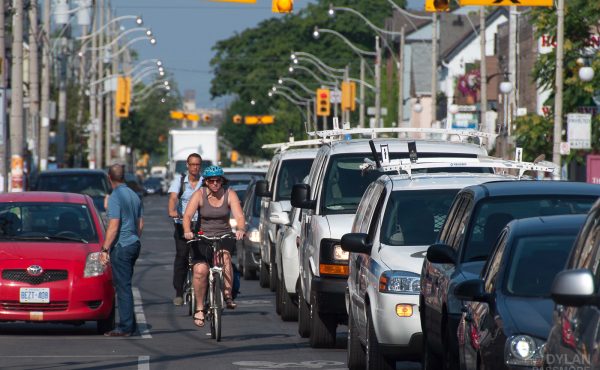
On a municipal level, road sensors (usually embedded in the road) are used to provide counts of road usage. These real-time counts provide planners and the government with data which also determine whether you get an advanced green, or how long the green will be, and what the messages on digital signage alerts will be. These sensors are able to distinguish between cars, trucks, buses and bicycles. On a larger scale, the city performs a Cordon Count every five years to determine short and long term transportation plans and policy according to traffic entering the outer limits of the city, as well as the downtown core.
On a global scale, some of this government data is collected by map data providers such as Navteq, Tele Atlas, and Inrix. Navteq claims to have over 80,000 sources of data from around the world, and updates its real-time traffic maps every 60 seconds. With many different sources for data (including government and private sources, as well as “floating car data” such as personal mobile phones which are monitored through cellular networks), GPS manufacturers have had a whirlwind of providers to chose from. Google Maps (which currently comes pre-installed on iPhones) had contracts with all three of the above providers within the span of five years. It is possible that Google will eventually collect all of its own data, thereby eliminating the cost of its current providers such as Inrix. It is also rumoured that Apple (which recently bought out Placebase and Poly9) will be using its own data and eliminating Google Maps from its devices. With more and more road data readily available, mapping out real-time traffic is becoming a more streamlined process, being offered in a more precise manner, which is readily available to the public.
It does not stop there. Navteq has already started working on pedestrian-related data opportunities. In addition, projects such as the Copenhagen Wheel – a ‘do it all’ wheel that transforms your ordinary bike into an e-bike – are lending to a new set of road data which not only offers real-time traffic data for cyclists through their smart phone, but also maps air and noise pollution, ambient temperature and humidity. There is no doubt that this data will lead to more and greater detailed maps, from which one will be able to make a much more informed decision on their route of travel.
The roads are definitely alive and initial doubts about real-time traffic data accuracy is being fine tuned into a very sophisticated system. The possibilities seem endless and no one is left unaccounted for. So on your next bike ride, or walk along a quiet road, remember that big brother is watching.
4 comments
Uhh, far from it. Manually counting is still done, because there is no other way to accurately count cars. That being said, most manual counting these days is for error checking pneumatic counters or for small scale counts.
All of these technology ideas are wonderful, but I really don’t see them replacing manual counting anytime soon. The biggest problem is self-selection.
As an aside, did you actually bother talking to any planning or transportation experts before writing that first line?
I had a comment posted earlier, but it seems to have disappeared. What I said was this:
Actually, manual traffic counts are very much still done. There are a number of reasons, but they are done as to error check pnuematic counters, which can get confused with larger, multi-axle vehicles, and they are done for smaller sites.
As for technology, it has all the same problem that most other traffic studies of this type have: self-selection. Only a certain percentage of people have smart phones, or want to run this app.
But given your first line, I wonder if you even talked to any transportation engineers or planners before you wrote this. I suspect not, which is sort of sad.
Corey, this peice is on real-time traffic data and how it is collected/distributed to GPS devices. Yes of course manual counts still exist, I think you missed the joke in that line… (it was a pretty long time ago that carriages were roaming the streets of Toronto).
While they work on smaller sites or for occupancy rates, vehicle classifications, etc, manual traffic counts are not as practical on a larger scale and where real-time info is needed, like for ITS. Manual counts or surveys do play a big role in the ‘fine tuning’ of ITS, but again, do not directly provide real-time data. Like I said, Navteq uses over 80,000 sources – that doesnt suggest that they are only in-situ’s / road sensors (as these only provide limited coverage)… FCDs were mentioned as another source…. this does not only rely on GPS , but also cellular probe data which is able to work off of a huge source of info/devices thereby making it one of the most cost-efficient methods… the point is that there are many sources (which were not meant to be exhaustively listed in this blog), but rather to show that together, they are able to paint a fairly accurate picture of the real-time traffic around us, via a process which is becoming more and more complex with the exploitation of each type of source… meaning now we are starting to look at windshield wiper status, ambient temperature, different types of acceleration, etc. (ie. the Copenhagen wheel).
Has the real-time traffic feature on GPS devices vastly improved in the past few years? Of course, and while that is in great thanks to manual counts and checks, i think there is a lot to be said about the new technologies emerging, and/or evolving methods…and to answer your question, I consulted a former manager of transportation for the city of toronto for this piece…
Niki, I guess it depends what you are looking for. If you merely want real time information about traffic to make routing decisions, these devices can work.
If you want origin/destination and traffic information to make long term planning decisions, you still have the self-selection bias issue or you have a privacy issue. You might be able to control for self-selection mathematically, but I doubt it. Look at all the trouble polling firms are having.
If you want a real world example of selection bias, take a look at the results from the Seattle OneBusAway project. Their report (http://wiki.onebusaway.org/bin/download/Main/Research/BrianFerris-Dissertation.pdf page 112)
” that our survey respondents are more predominantly male and younger[than King County riders], while income levels are comparable.”