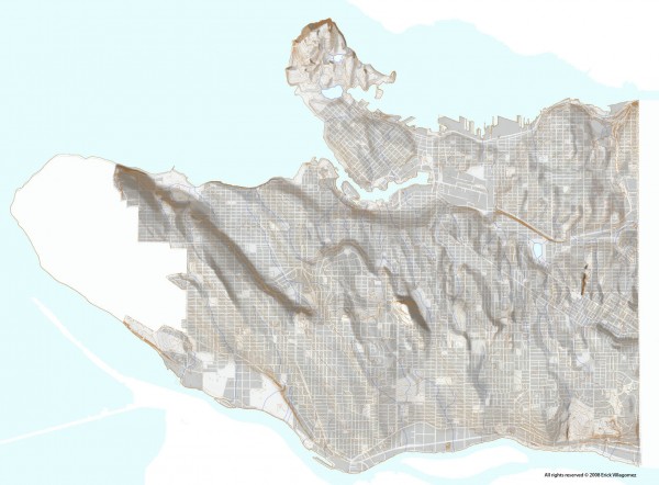

Upon publishing the relief map, a little while back, I was approached by many people who wanted to be able orient themselves relative to the topography depicted. The most popular (and logical) suggestion was to overlay and label streets on the map.
Given that I wanted be a little bit more subtle and really make people engage the structure of the city, I decided to post of the block figure-ground map of the City of Vancouver. This, I thought, would make people learn streets not through names but through their physical attributes and location – Kingsway slices diagonally across the eastside reorienting the grid along its path, Cambie lies almost dead centre with its large bend curving around Queen Elizabeth Park, and so on.
Admittedly, it may a bit naive to think that people would go to such trouble. However, to me, I think knowing the physical structure of ones city is not only interesting, but also important to making a city ones own. It forces one to make a direct connection to where they are – beyond simply memorizing names – and seek out relationships between the city structure and the larger landscape we inhabit. Simply put: it is an easy way to start learning about our city.
So, finally – and in response to all those who asked – here is the map that will allow you to find yourselves amidst the larger landscape structure of the city. Although there are still no direct labels (my apologies who wanted instant gratification), there is more than enough information to figure things out.
Have some fun! See if you can figure out what streets are where, why some bend, and why grids shift. Geeky? Yes. But pretty fun nonetheless.
***