
[EDITOR’S NOTE: We are please to offer our readers the fifth part of George Poulos’ in-depth series focusing on the Comprehensive Costs of Transportation and Metro Vancouver. If you missed past articles, you can read them here: Introduction, Part 1 – Costs and Benefits of Transportation in Vancouver (Part 1), Investing in Transit is Imperative for Metro Vancouver (Part 2), The Business Case for Active Transportation (Part 3) and Transportation Equity and what it Means for Metro Vancouver (Part 4).]
Although the unit rates illustrated in Table 1.0 may be used to substantiate several interesting perspectives related to the topical issues in the region today, they can also serve as a ready operational-level tool for planning and engineering applications. As mentioned in the Introduction, similar unit costs are already employed in many European countries to conduct cost-benefit analysis of transportation infrastructure programs. To this end, they can be used to monetize changes to travel time, congestion, safety statistics, environmental impacts, and a series of other factors resulting from new infrastructure projects.
In the past, these applications have typically centered on evaluating traditional transportation infrastructure projects; anything to do with roads, bridges, tunnels, railways, or various transit modes. However, unit costs have recently been put towards evaluating active transportation strategies. A cogent example can be drawn from the Danish city of Odense’s “Cycle City” program, which was a combined cycle infrastructure and promotional campaign. A subsequent analysis of cycling statistics following the implementation of the program revealed some significant results:
- 35 million new cycling trips
- Accidents reduced by 20%
- 500 more years of life added to the city
- Mortality between the ages of 15-49 fell 20%
- Half of new cycling trips are ex-motorists
- 33 million DKK saved in health costs
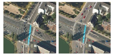
On a more particular scale, unit costs can also be put towards analyzing individual active transportation infrastructure projects. An example of such an analysis is included in the report entitled “Samfundsøkonomiske analyser af cykeltiltag -metode og cases” (Socio-economic analysis of cycle initiatives -methods and cases) completed by COWI (2009) for the City of Copenhagen. This report discusses (among other projects) the reconstruction of the Gyldenløvesgade- Nørresøgade intersection, which is illustrated below in Figure 1.0.
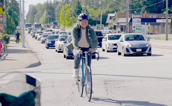
This intersection reconstruction provides an interesting parallel with a similar project much closer to home – the Vancouver downtown separated bike lanes. As discussed in A Business Case for Active Transportation, much has been about the appropriateness/utility of the change of space that was made on Hornby and Dunsmuir streets. At present, the true impacts (both positive and negative) can only be speculated at, or are otherwise very preliminary – a fact that I suspect plays no small part the continued uncertainty surrounding similar right-of-way redesigns.
In adding a bit of clarity to the issue, the unit costs illustrated in Table 1.0 could be used to establish a framework whereby a number of tradeoffs can be accessed and monetized. This could go a long way in replacing speculation with analysis. After all, similar processes are already standard features in Denmark and other places when walking and cycle infrastructure projects are proposed. I see implementing such procedures as beneficial to all parties:
- Such processes would help legitimize these projects in the eyes of the higher governments and the industry, which have at times been slow to adopt new engineering practices to suite modern planning contexts. This would be no different than the current processes that are common place (and in some cases required) for traditional infrastructure projects;
- These processes would help to assuage public skepticism that appropriate scrutiny has been paid to potential tradeoffs when implementing such projects, and help to ensure the best options for implementation are selected;
- The outcome of such analyses could also potentially benefit municipal council’s efforts to promote further transportation demand management policies, and contribute more useful literature to the global base of best practices in active transportation planning.
To this end, I have proposed a preliminary framework for analyzing such projects using the Vancouver separated bike lanes as an example. This is illustrated in Figure 2.0. As can be seen, this project is an excellent example of the fact that infrastructure project in public right-of-ways are often couched within a framework that includes considerations beyond transportation impacts.
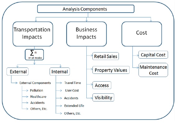
Understandably, capturing a complete list of tradeoffs requires substantial data inputs. In some regards, this is complicated by the fact that many pathways and outcomes are not yet entirely clear and would benefit from more longitudinal data collected over many years. This is especially the case for business impacts such as retail sales and property values for businesses along the alignment of a greenway, separated bike way, or the like.
In the meantime, however, unit costs would allow for more comprehensive transportation impacts to be calculated given the appropriate data and methodology. As can be seen from Figure 2.0, the calculation of transportation impacts is holistic; it considers any user who is affected by the changes in question. This includes both system users (i.e. cyclists who may be using the bike lanes) and non-system users such as motorists, transit users, or pedestrians travelling on adjacent or nearby streets. Furthermore, it consists of the totality of both internal and external cost/benefits which are derived as a result of this activity. In other words, it represents the total value or sum of the monetary tradeoffs that relate to transportation outcomes.
For example, a bicycle lane may decrease travel time, improve safety, result in health benefits for “X” number of cyclists (and for society), reduce pollution, or reduce vehicle trips, yet increase travel time for “Y” amount of motorists. In the end, the magnitude of these tradeoffs determines the total value of transportation impacts. With this in mind, we can make trial of a hypothetical example to demonstrate what part of this analysis might look like.
Referring to the bicycle counts on the separated bike lanes maintained by the City of Vancouver (found here), for present purposes we can make the assumption that total trips on the bike lanes (both Hornby and Dunsmuir) are equal to the total number on Dunsmuir plus 20% of those on Hornby (to minimize double counting). With this number, we can estimate total external benefits for system users which, as Figure 2.0 illustrates, are only a component of total transportation impacts. Making a further assumption that 40% of trips on the bike lanes are averted Passenger Vehicle trips, 50% are averted Transit Bus Trips, and 10% are averted Skytrain Trips, results are illustrated in Table 6.0 below.
Of course, these results would need to be considered together with internal impacts to system users and total impacts to non-system users to round out the complete picture of transportation impacts. For this, more specific data would be required. However, provided this data is available (of which most would be readily attainable), it would be a relatively simple process to use unit costs to conduct estimates of comprehensive transportation impacts. These could potentially be used to generate estimates of impacts very similar to those determine for the City of Odense, mentioned above. Taken together with business impacts (which hopefully will become more clear in the future), a fuller understanding of the impacts of right-of-way redesigns could become available in the future.
Although the above examples have discussed the potential application of unit costs to active transportation projects, they can be readily applied to monetize the transportation impacts of various infrastructure projects or transportation strategies, across many different modes. This, therefore, makes them a very useful tool for practitioners and governments to add an additional and very important dimension to the analysis of such initiatives – especially since existing methods to monetize transportation impacts are so scarce.
***
Just in case you missed earlier pieces of The Comprehensive Costs of Transportation and Metro Vancouver
- Introduction
- Part 1 – Costs and Benefits of Transportation in Vancouver
- Part 2 – Investing in Transit is Imperative for Metro Vancouver
- Part 3 – The Business Case for Active Transportation
- Part 4 – Transportation Equity and what it Means for Metro Vancouver
**
George Poulos, EIT, MSCP is a transportation engineer-in-training as well as a recent Masters graduate of the School of Regional and Community Planning (SCARP) at UBC. He has previously worked for consulting engineers on a variety of transportation and municipal projects. Originally from Ontario, he currently lives in Vancouver.