
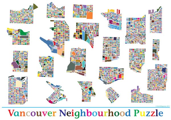
Vancouver Neighbourhood Puzzle. Click here for a larger version
![]()
Black-and-white ‘figure-ground’ city maps – that depict blocks as black and streets as white, or vice versa – are very common in fields dealing with urban form. Through its use of high contrast, this method of representation serves well to compare block structure and street network: issues that many deem fundamental to analyzing and understanding the urban fabric. This being the case, it is rare to see variations on the traditional black-and-white figure-ground maps – or reasons to deviate from the norm, for that matter.
The map you see above began as an exploration in how best to graphically compare the form and geometry of blocks across Vancouver neighbourhoods. I had no inherent interest in the space between blocks (the streets) beyond how they contribute to block geometries. This desire ultimately led to colouring each block a different hue. Given that each hue as a different value (relative lightness and/or darkness) and level of emphasis, it allows one to see the graphic pattern behind the block structure more readily than the typical block/street bias of a standard black-and-white figure-ground map.
Since I was also interested in neighbourhood patterns, I decided it would be interesting (and fun!) to create a Vancouver neighbourhood puzzle, by exploding and dislocating each group of blocks by the ‘local area boundaries’ as defined by the Open Data provided by the City of Vancouver. The result is seen here: a playful yet informative graphic.
This process was so fun that my Little Ones wanted to help, and they played their part in digitally colouring a lot of Vancouver’s blocks…and in doing so learned a bit more about their city. (Thanks, Kids!)
Needless, to say, I think this is a marketable product in waiting. So, if anybody is interested, fire me a note. 🙂
In the meantime, test your knowledge of Vancouver’s local areas/neighbourhoods by trying to guess the name of each neighbourhood by urban form and block geometry, alone. It’s a great exercise! As the name implies, you can also print up the sheet, cut out the neighbourhoods, and put them together to form Vancouver. Also, very fun!
I’ll publish another piece with the names of each neighbourhood within the next couple of weeks.
Enjoy!
***
Erick Villagomez is one of the founding editors at Spacing Vancouver. He is also an educator, independent researcher and designer with personal and professional interests in the urban landscapes. His private practice – Metis Design|Build – is an innovative practice dedicated to a collaborative and ecologically responsible approach to the design and construction of places. You can see more of his artwork on his Visual Thoughts Tumblr.
2 comments
This is brilliant. Could you do one for Toronto?
Thanks for the kind words, Richard. Unfortunately, I don’t have a block map of Toronto. If you know where I could get one, please tell me and I’ll see if I can put one together!
E