
![]()
There is no question that Vancouver is a densifying city. Despite all the excitement and acrimony that comes with that prospective change, the majority of its land is still locked into single family housing zoning districts. On Wednesday January 20th, the Urbanarium will have presented a panel of players of the Region’s development past and future to debate one of the most powerful and unasked questions surrounding Vancouver’s future density: should we “Open All Neighbourhoods To Densification?” In advance of that debate, we wanted to visualize and analyze some of the impacts that single family housing districts have on the Vancouver’s form and structure.
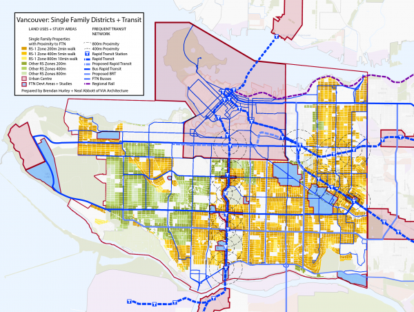
The question of whether we can do better by this land, its owners, and the people who want to have the opportunity to live in these neighbouhoods is a serious one. The visual impact of the Single Family zoning parcels shown in the map Neal Abbott and I created with VIA Architecture displays, rather quickly, how much of the city is still officially zoned as single family. Our map of the City of Vancouver breaks down the most common RS1 One Family Dwelling District in Orange and all other RS Single Family Zones in Green. This analysis also takes into account that many of these neighbourhoods are transit oriented, despite their official low density designation.
RS-1 One_Family Dwelling District
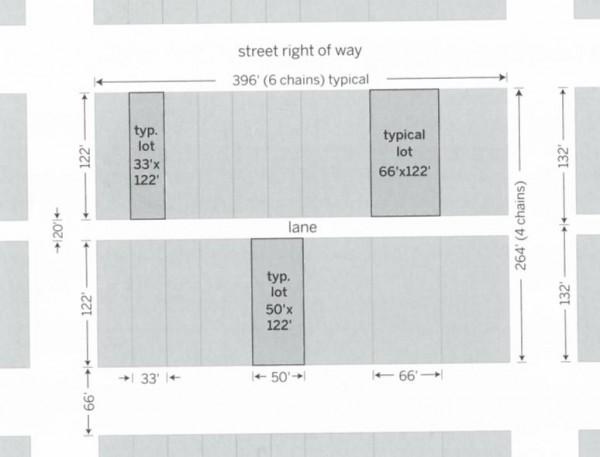
Single Family Housing became near ubiquitous in the interwar period. The city’s farm land was divided out along the grid of streetcars and developed further and further southwards with new tracts of housing. The surveys that defined properties for this grid were similarly focused on a streetcar suburbia. Outside of the early City’s Victorian core, and some of the Post-War ranch properties in the South of the city, most of this grid was divvied up into regular chain (66ft or ~20m) lots and blocks. Depending on configuration that meant that the most common type of lot in the city was a half chain (33ft or ~10m) wide. Lanes divided almost every block most were and were 20ft (or 6m) and most blocks were 4 chain deep. That meant that the most common development lot in the city had a shared scale of approximately 33ft x 122ft (~10m x ~37m). There are variations, but this lot type is almost ubiquitous.
The types of allowable housing on these subdivided lots changed drastically and some of the beloved forms we now protect as heritage have been made illegal – many times over – with new restrictions on those codes. The fast paced and concentrated development pressure spurred on by the streetcars quickly was released in the post war era with broader car oriented suburban development across the region. The most common zoning regulation on these lots was based on the singular faith that single-family zoning in lower densities was as a deterrent against slums and the negative elements of the then industrial city.
Connecting Transit
For the last number of decades Vancouver has become a model of master planned density set along a connective transit system. Redevelopment and reinvigoration of the urban core and the creation of new neighbourhood and town centres along transit corridors has branded Vancouver as a city of density. However, the power and persistence of the Single Family zoning districts still has a vast impact to the shape of the city. Outside of specific core and study areas, Vancouver remains largely dominated by this typology.
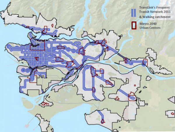
Vancouver is a transit oriented city that has a near complete grid of Frequent Transit Corridors – most of which were set into place in the Streetcar era. It is rare for properties to be more than 800m – about a ten minute walk – from one of these transit routes. Yet, it is easily observed that beyond some directly adjacent commercial districts, and a few neighbourhood planning study areas, much of the land base crisscrossed by this transit is still dominated by single family district regulations. Precincts around stations and transit are powerful places to increase densities and maximize transit use, but what about the rest of the City. As we look to a more connected and complete city, we chose to begin by analyzing how this relationship between single family housing and transit were interrelated.
By the Numbers
Our rough analysis in GIS calculated about 67,700 single family zoned dwelling parcels in the city. It will be noted that these numbers are rough but have been “corrected” to remove large parcels – often city parks and schools remain RS1 even after their use change – and small parcels – that could be vestigial segments of subdivided properties and streets. The RS1 One Family zoning district presented in shades of orange represents approximately 51,900 parcels. While the remaining 15,800 parcels presented in varying greens represent the other RS2-RS7 Single Family Districts’ properties.
The map presents the network of Frequent Transit Routes expected in the city over the next few years and highlights the routes presented in both Translink and City of Vancouver transportation plans. Major rapid transit stations on the existing SkyTrain have been marked and 5 minute and 10 minute walking circles have been overlaid onto the map. It is striking to see how many lots of single family housing are present within these station areas. Areas outlined in Blue are either Frequent Transit Network development areas or Planning work currently underway and completed by the city to create new transit oriented multi family zoned urban centres.

Our analysis looked at the amount of properties within certain walking distances to frequent transit, to see how much of the ‘Single Family; city is actually located within reach of transit oriented corridors.
At 800m or a 10 minute walk we found that 67,600 or 99.8% of the single family lots were represented. This number suggests that almost all of the single family housing is within a reasonable distance from corridors to be considered transit oriented. Often this limiting distance is the outer edge of a transit area plan. Here we represent it in the lightest shades of orange and green on the map.
A 5 minute walk is considered to be the common distance from transit at which people are likely to consider it as part of their daily routine. With 65,100 parcels within this 400m distance we can consider 96.1% of the city to be within range to be considered oriented to a frequent transit route.
In order to look at direct integration with transit we added sites within 200m of a transit corridor. In essence these are sites that are less than a block or two from a frequent transit corridor. They are presented in the darkest of our colour range and account for 44,800 parcels. We consider these single family lots to be directly oriented to transit. They represent 66.1% of the total set of RS Zoned lots in the City.
Vancouver is a Connected City
With the vast majority of lots within an attainable transit catchment, the City of Vancouver’s single family zoned lands can be considered connected. The debate of how to treat and what to do with these lands seems appropriate. The connective tissue is there to have our city look at a more urbane future. How this moves forward will require tact and skillful balance, but we seem to be at a place of evidence that the long overdue debate about what kind of city we want to live in can begin.
***
Brendan Hurley is a Vancouver based urban design planner and frequent contributor to Spacing Vancouver. For the last three years he has been working with VIA Architecture on transit oriented development and design. You can follow him on twitter under @urbanecondition.
Neal Abbott is a Intern Planner at VIA Architecture and is finishing his degree at UBC’s School of Community and Regional Planning.
***
This Post is also available on the VIA Blog.

3 comments
Indeed it is time to look at how to gently densify our highly connected inner suburbs. Wished I could have participated in the debate – a bit far from London UK though!
https://www.linkedin.com/pulse/cbc-interview-do-we-need-new-vancouver-special-michael-mortensen?trk=mp-author-card
Michael, I’m glad to hear your voice in this. I will be attempting a “part two” of this discussion where we will look at furthering some of the response to your thinking about the potential for a “New Vancouver Special”.
Cheers,
Brendan Hurley.
Of course we need a balance of single family zoned neighborhoods, duplex, triplex, multi family and many more diverse forms of condos and town homes. Having RS zoned parcels within 400m of skytrain or b-line routes is absolutely counter intuitive. The zoning and ideals are still 1970’s. If the pressure isn’t relieved soon the effects will not be realized until it is far too late. Many smart, successful people in their 20’s leaving town. This is possible to allow more titles without hurting equity. If city was smart they would raise the fee for subdividing to a silly number (10K$) or so and allow any RS zoned parcels within a 5 min walk to subdivide the title for 2 families. The homes still have to be redeveloped in mass amounts before upward price pressure would be relieved. Heaven forbid, a 2 million dollar parcel could be redeveloped by 2 families paying 1 million dollars each (just for land costs). Also any heritage or special areas of Vancouver would still be preserved (shaugnessy, west pt grey, southhlands etc.)