
Looking west down Queen Street
At eleven yesterday morning I learned that Global television wanted to interview me, an arborist, about the late changing of the leaves, in an hour — in a helicopter. I would have suggested doing the interview on a footbridge over the Don Valley, but when Global does a nature story they go big. And yes, I recognize the irony of burning significant amounts of fossil fuel to videotape leaves that have not yet fallen because of the unseasonable weather. However, it presented the opportunity to educate a wide audience about trees in a compelling way. And I got to ride in a helicopter.
After the interview I was able to take some photos, a few of which I provide below.
So first, a quick primer on why leaves change colour in the fall. Throughout the summer, leaves are full of chlorophyll, the green chemical that through the process of photosynthesis converts the sun’s energy into sugars (remember grade 9 biology?). The sugars are stored in the roots and trunk, and then used to fuel the tree throughout the year as it grows roots, branches, leaves, and fruit. In the fall, the nights get longer, the weather gets cooler, and the tree begins to shut down. Tissue forms at the base of each leaf, causing them to eventually fall off.
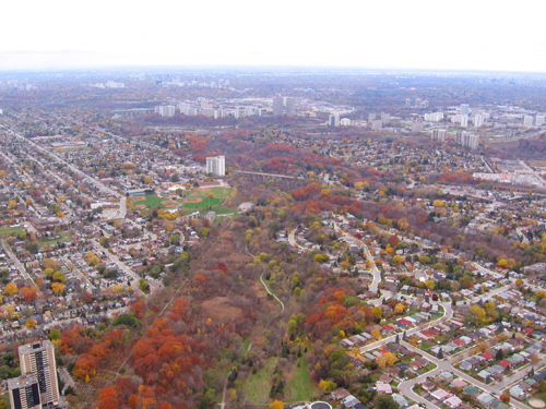
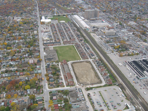
Looking northwest up Glen Stuart Ravine
As the bright green chlorophyll drains from the leaves, other pigments like carotenoids (which make up the oranges and yellows and have been in the leaf all along) become visible. Anthocyanins (which provide the vibrant reds and purples) are produced in the fall when some sugars become trapped in the leaves.
The vibrancy of the colours and the time the leaves drop is dictated by temperature, available moisture, and most importantly, shorter days. This year, as a result of the long summer drought, followed by a mild fall with no frost and cool rains, trees are holding their leaves longer. They are doing so partially to take advantage of the unseasonably good growing conditions by storing extra sugars they were unable to during the summer, because of the crippling drought.
One fear is that we will now have a heavy snowfall or ice storm, which is more than likely considering it is mid-November. If leaves are still on the trees and the conditions are just right, snow and ice will stick to them, greatly increasing the weight of each limb, causing some limbs to break. The impact on the urban forest, not to mention the people and property below could be significant —all the more reason to have an ISA certified arborist routinely check the condition of trees on your property and conduct preventive maintenance if required, so they will be much less likely to suffer damage.
These photos were taken looking west from around the Scarborough Bluffs area (anyone with a keen eye for streets and landmarks please point them out). What I think is so fascinating is how clearly it demonstrates the idea of canopy cover. The deficiency with Google maps in this regard is that the photos are taken in the winter, with leaves off, so you can see the roads, but not the trees. In these photos many of the leaves are still on and are vibrant colours, making it easier to identify particular species.

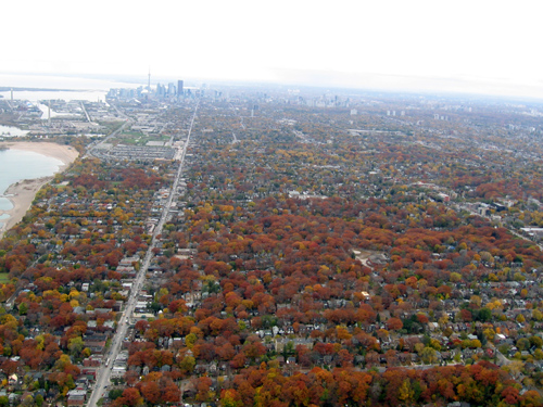
Looking southwest at Glen Stuart Ravine and The Beach(es) Neighbourhood
The above photo shows a remnant patch of the red and white oak forest that would have dominated this area prior to the arrival of Europeans. Kingston Road is in the foreground. The canopy cover, or simply the area of ground covered by trees, is almost 100% in the ravine and surrounding neighbourhood. However, north of Kingston Road, the cover is much lower, likely around 15%. South of Kingston Road are the reds and oranges of the oaks, to north are the yellows of silver maples and Norway maples that were planted as street trees nearly a century ago. Off in the distance (in the top right corner) is the new, denser built, Woodbine neighbourhood.
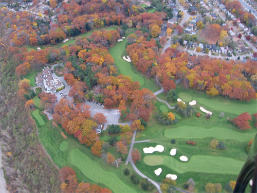
The Hunt Club golf course and clubhouse
The above photo is of The Hunt Club golf course. The reds and browns are oaks, remnants of the pre-settlement forest. The sliver of green trees to the north of the palatial clubhouse is, I think, a grouping of remnant white pines. In the centre foreground are the bare white branches of a lone paper birch. The immaculate fairways of green grass carved into a centuries old forest are both beautiful and disturbing.
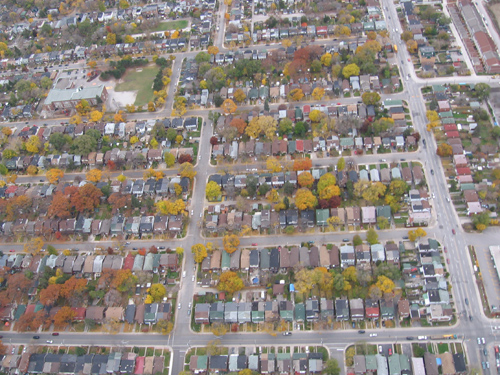
Looking west on Gerrard
The main road running up and down in the photo above is Gerrard. The darker lines to the right of it (north) are train tracks, while the large buildings in the top right corner are the apartments at Main and Danforth. To the south of Gerrard is an older neighbourhood with the yellows of maple street trees and other large trees in rear yards, elms and lindens, the occasional willow. To the north of Gerrard (in the center of the photo) is a new subdivision — note the neat rows of houses with no trees in sight. There are likely trees there, but they are still tiny. It will be decades before they grow as large as those to the south.
Looking east at a row of typical residential streets (not sure which ones, do you recognize your house?)
The canopy cover in the above photo is about 15% (Toronto’s goal is to have 35% cover). All the yard space shows that there is the opportunity for many more trees. The yellows in the front yards are likely more Norway and silver maples. What is striking is that some streets only have two or three left. At one time the entire street would have been yellow with large maples on nearly every yard; most have now died. The red colours to the south (left of the photo) are likely remnant oaks in the rear yards, spared from the axe because they were behind the houses away from the construction that took place in the front to build the houses, roads, sidewalks and utilities such as gas, electricity and water.
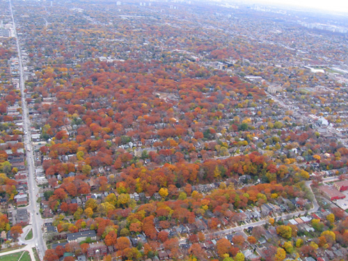
Looking east at the Beach(es) Nieghbourhood, bounded by Queen Street to the south (left) and Kingston Road to the north.
The canopy cover in the above residential neighbourhood is probably over 50%. This is the many mature oaks of the Beach(es) that were left standing when the area was built up in the last century. Houses were built by hand and with horses, and set in amongst the towering trees. This demonstrates the potential to grow our canopy. With some hard work and good planning all residential neighbourhoods in Toronto could be graced with a similarly beautiful protective canopy of trees.

Me looking stunned to be in a helicopter.
____________________________________________________
For more info on TO’s urban forest visit LEAF and the Toronto Tree Tours.

22 comments
Great story and interesting pics.
These photos were taken looking east from around the Scarborough bluffs area
The photo shown is actually looking west (or *from* the east), since we see the Toronto skyline – and, of course, since the lake is on the left it must be south.
The immaculate fairways of green grass carved into a centuries old forest are both beautiful and disturbing.
Definitely disturbing. I’ve given up golf, in large part for environmental reasons, and I have this argument all the time. Golf courses are *not* green friendly (excuse the pun). The picture shows just how problematic golf course development can be.
That photo with the typical residential streets where you weren’t sure where you were? Gerrard East at Scarborough Beach, looking west.
Here’s the Google Map:
Nice pics, by the way.
What an awesome opportunity, to go up in a helicopter and see the city from above. Thanks for sharing it with us!
I hate news helicopters, rarely do they add anything to the story.Nice to see one used for a good purpose instead of polluting and making noise.
Thanks for sharing the view from the helicoptor – and it’s up there every day, seeing the even-larger wa$te of the daily cartillery of tenthousands of mobile furnaces heating everything up. (it’s sometimes really hard to get out of situations and be a gashouse green in the core).
Another waste is maybe seeing the old Metro Marker program in the suburbs where Metro put rose-coloured concrete at great stretches of the curbs of their big carterials to mark their turf – but it was best viewed by the traffic helicoptors.
Putting down rose-coloured concrete for our bike lanes however, is just too costly, though we should ask why not on Bloor St. huh? Even $25K a km to repaint Bloor for bike lanes seems too high to some councillors, though cars are the unnatural enemies of trees in many ways…
Live Maps seems to have summer images, so you see more of the canopy (Live Maps version of Sean’s link above).
No matter how much you walk or bike Toronto’s tree-lined streets, the view from above really does drive home the magnitude of Toronto’s “urban forest”. (And yeah, give a TV station a helicopter and they’ll find any excuse to use it.)
You mean drought, not draught (British for certain senses of “draftâ€Â).
Terrific pictures. Really shows you where our neighbourhoods are failing to plant trees. Everybody always says they love the mature trees in older parts of the city, then no one plants any on their own properties. Kudos to you and Global News both for this interesting perpspective. It’s nice to see there are uses for those choppers other than just following high speed chases.
Oh, man, you gotta get back on Facebook so you can use that last shot as your profile picture.
McKingford and Joe>
Thanks for pointing out my typos, they have been corrected.
Photo Location:(Looking northwest up Glen Stuart Ravine) is actually Taylor Creek Park.
The valley in the foreground (bottom half of the pic) is Taylor Creek Park.
You are looking north/west towards the forks where the valley meets the East and West Don Rivers at the Don Mills/DVP interchange.
The bridge that spans the park is O’Connor Drive, just east of Woodbine Avenue.
The park with baseball diamonds (red blotches) that is just to the south (below the bridge) is Stan Wadlow Park which fronts on to Cosburn Avenue.
The tall white apartment building (just to to the upperleft of the baseball diamonds) is right at the corner of Woodbine & O’Connor.
Tall set of towers is far upper left is the Thorncliffe community.
Upper right is Flemingdon Park.
Tall buildings in lower-left are a TCHC property at 444 Lumsden
nice pics, reminds of the time that I took flight training at the island airport.I always loved the view during each and every flight. Watching Toronto change was also amazing.But the “fall” colours are always beautiful….
More photo comments
In the photo of Taylor creek park, the straight line on the left (south) side of the ravine is the old right of way of the Canadian Northern Railway’s Toronto-Ottawa line
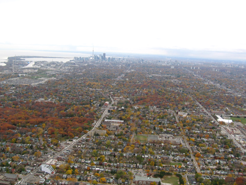
In photo 3, the bright roofed building on the right side is the Ted Reeve Arena, at Main & Gerrard
In photo 6, the new subdivision is built on the site of the old Danforth railway yards, and yes, there are trees, but they’re all saplings. The large buildings are actually at Main & Danforth
Tom > thanks for the correction on the location of the three brick buildings as at Main and Danforth.
Those buildings always seemed so out of place to me, like they grew prematuraly, faster than the surrounding neighbourhood. The corner has aspirations to be a the Yonge and Eg. of the east, a title that will more likely go to Broadview and Danforth.
Wonderful posting. The photos are great and instructive but I especially appreciate the botany reminder: i.e., that trees don’t “turn colours” in the fall but that colours already present in the leaves become visible.
Thanks for sharing those great photos! I am a sucker for air photos.
Todd>
No problem. The site was developed back in the 1970s, after the previous tenant closed down, I think it was a lumber yard. I’m surprised the whole neighbourhood isn’t highrises, what with a GO station (Danforth) and a subway station (Main Street) so close together.
Hi Todd,
I enjoyed the article, that must have been a fun experience. I would like to have a discussion with you regarding Toronto’s canopy cover, and how it has changed since 1985. I would also like to use some of these pictures in my technical research paper on this topic if possible. Please email me to discuss.
Regards,
Harry Morrison
How great to see your photos and read your commentary; it’s just a pleasure to read an intelligent and informative discussion of trees in the urban landscape. I have a habit of looking at the trees around me and assessing what’s going on with them, and just last week had the chance to fly around and look at some eastern Massachusetts forests from the sky. We had the same drought here, and it was fascinating to see that the ubiquitous Norway maples in populated areas were still yellow, one week away from Thanksgiving. Wonderful too to see the great tracts of oaks, interrupted here and there by white pine plantations, and punctuated infrequently by small stands of brilliant golden larches.
Thanks for showing us what you saw. I’m bookmarking your blog right now.
Deb >
Thanks for the comment. It is interesting to hear that trees were holding their leaves later in other areas as well. We ended up getting snow shortly after I took these photos. Fortunately it was not enough to cause damage, but to see snow sticking to green and yellow leaves was still a strange image.
Nice work Todd!
Two things close to my heart trees….and flying. I’m climbing and pruning trees at the Hunt Club with Able Tree on their winter pruning contract. I love working in big beautiful Oaks. 90′ plus canopies are what we are supposed to live under…
Nice work. I think the second photo is looking up Taylor Creek Park.