

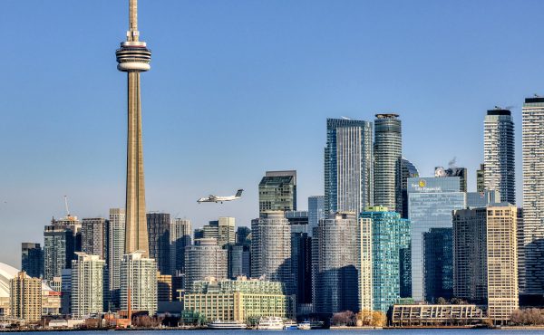
Last week I went to the see the presentations of the four design teams vying for the opportunity to redevelop the Lower Donlands. A massive amount of information was given, which was to be expected given the size of the area they’ve been asked to redevelop and the various goals they were required to achieve.
Since the public exhibition at BCE Place closes tonight, I thought I’d offer some highlights from the notes I took at the presentation last week. If anyone was at the presentation and remembers anything I haven’t included, please leave a comment below. What I’ve written here is far from comprehensive, but it should at least give you an opportunity to understand some of the finer details in each presentation.
Presentation 1: “Wandering Ecologies” (Warning: PDF)
Team:
Weiss/Manfredi, New York, NY
du Toit Allsopp Hillier (DTAH), Toronto, CANADA
McCormick Rankin Corporation
Golder Associates Ltd.
Biohabitats, Inc
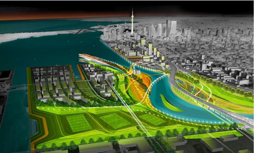
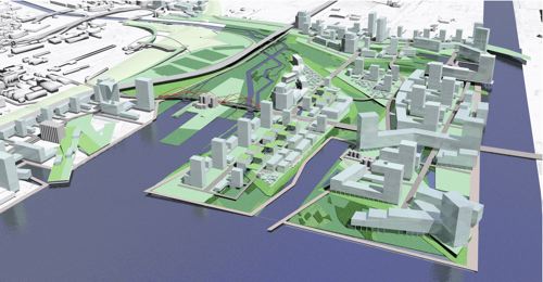
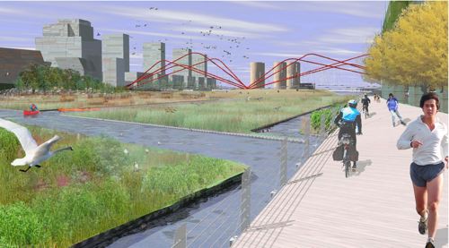
This team includes du Toit Allsopp Hillier, part of the West 8 team that won the challenge to redesign the Central Waterfront, so I expected a lot of green elements in their submission. As they spoke of the lost geography of the land, which consisted of the largest marsh in eastern Canada, they expressed hope that they would be able to “transform a place of lost nature into one of many natures.”
The name of their presentation, Wandering Ecologies, refers to their hope that they can transform the area into a place where “recreational, living and cultural activities are free to wander and overlap.” Their first priority is to naturalize the Don, and create a meander in the lower part, which is evident in the image above. They also plan to recycle the dug up land to create different topographies, transforming the currently flat landscape to one of different elevations.
They expressed a “love” for the Gardiner Expressway, but wanted to get rid of the Lakeshore, hoping to instead create bicycle paths and pedestrian areas beneath the elevated highway. They also propose to extend Queen’s Quay east, creating meandering roads that lead to the Lower Donlands. There is also an elevated outlook that looks west over the islands, the city, and the lake.
A mix of high-density mid-rise buildings would make up the built part of the environment, modeled after “the world’s great liveable cities.”
Presentation 2: “Don Mouth Park” (Warning: PDF)
Team:
Atelier GIROT, Zurich, Switzerland
Office of Landscape Morphology, Paris, FRANCE
Jà¼rgen Mayer H., Berlin, GERMANY
ReK productions
Arup, California, USA
Philip Ursprung
Applied Ecological Services
This team said they took four different elements into account when creating their submission: Water, Landscape, People, and City. They noted that historically, the Don River’s mouth has always looked like the curve of a hockey stick, and so to naturalize it and echo it symbolically, they propose a series of fingers that jut out from the land in a similar fashion.
They propose a radical change in the use of the land, removing all surface roads and land from the North Don Bank, and replacing it with water. Each of the fingers steps down into the water, creating opportunities for close interaction with the water, and acting as breakwaters should storms ever cause dramatic shifts in the water level.
They believe that by bringing the water into the land in such a dramatic fashion, Toronto will finally realize its dream of being a water city. They also hope that a building of “signature architecture” will become an acquarium, incorporating the Victory Silos and thereby maintaining the link with the area’s industrial heritage.
As for the built part of their design, they plan the highest density along Cherry Street, turning it into the main street of the neighbourhood. Transit-wise, a new Go Station at Cherry Street would become a major transportation hub for the area, and the bridge they propose for the river-crossing is also an iconic one, and actually prioritizes the pedestrian and cyclist crossing, relegating cars to the lower part.
Presentation 3: “River + City + Life” (Warning: PDF)
Team:
STOSS INC., Boston, MA
BROWN + STOREY ARCHITECTS, Toronto, ON
ZAS ARCHITECTS Inc., Toronto, ON
Brookner Studio
Nina-Marie Lister
Applied Ecological Systems
Pine + Swallow Associates
Nitsch Engineering, Inc.
Moffatt + Nichol
ARUP
Kidd Consulting
Consult Econ, Inc.
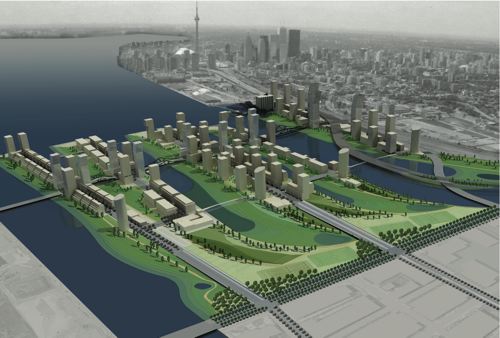
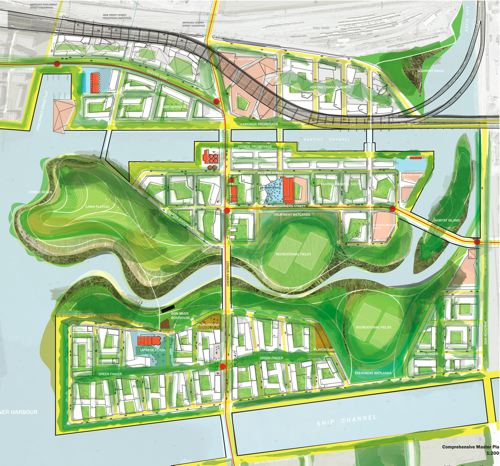
This team also “put the Don first,” but did so with the mantra that “Renew does not equal Restore.” They chose to “amplify the riverface,” where the lake meets the river and where most aquatic breeding takes place. They also create a new island, Essroc Island, that becomes not only a huge open public space, but also an event space for large public events.
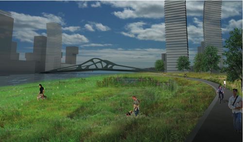
It is also over Essroc Island, and the reconfigured Don Mouth, that the spider-like iconic bridge stands as a gateway into the Lower Donlands. The bridge is not only visually iconic, but it also relegates each kind of traffic – pedestrian, cyclist, vehicular – to it’s own level so they do not interfere with each other.
The scale of their built environments is “lifted” from the nearby neighbourhoods of St. Lawrence Market, Corktown, and Yorkville, which should give the neighbourhoods an all-important human scale. They also create a destination, the Great Lakes Aquatic Centre, in a green-roof building that extends itself right over the lake (seen near the far left of the top image). It would incorporate the Victory Silos, turning it into a fish hatchery, heritage destination, water purifier, and maybe even a brewery (!?!).
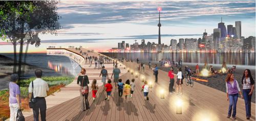
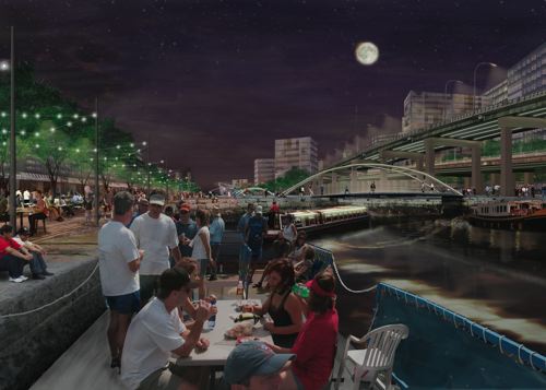
They propose to keep the granite and wood boardwalk suggested by West 8 going right around this section of the waterfront, too, keeping the public promenade at the water’s edge continuous.
Presentation 4: “Port Lands Estuary” (Warning: PDF)
Team:
Michael Van Valkenburgh Associates, Inc. (MVVA), New York & Massachusetts, USA
Limno Tech Inc., Michigan, USA
Applied Ecological Services Inc., Wisconsin, USA
Great Eastern Ecology, New York, USA
Greenberg Consultants Inc., Ontario, CANADA
Behnisch Architects, Los Angeles, CA, USA & Stuttgart, DEU
Transsolar Energietechnik, New York, USA & Stuttgart, DEU
RFR Engineering, Paris, FR
Totten Sims Hubicki and Associates (TSH), Ontario, CANADA
ARUP, Ontario, CANADA
This final team is led by Michael Van Valkenburgh Associates, Inc., which is already doing great work on Don River Park, a little north of the Lower Donlands. They propose to “relocate the Don Mouth to where it wants to be,” cutting through the land and into the Lake. Since the river’s mouth is an open space, they feel the landscape should be open, too, and so created a large, open field on the north west bank of the river. At the end of the Keating Channel, on the north bank of the river, they hope a new arts centre will become a signature piece of architecture in the area.
The area between the rails and the river contains a great portion of the built area of their submission, which makes sense given that it is currently an orphaned space. This large commercial centre would contain the shopping malls, grocery stores, and other neighbourhood amenities that would keep the residents from having to travel too far.
Another unique aspect of their proposal consists of making three incisions in the rail corridor, providing much-needed pedestrian access over the rail lands. The rail lands are often considered a greater barrier to the waterfront than the Gardiner, and these are vital connections to the rest of the city.
Finally, the team hopes to further accentuate water transportation between the Lower Donlands and the rest of the city, taking some of the burden off the Ferry Docks and creating an actual network of water transportation.
___
Unlike the Central Waterfront Redesign Competition, which had one or two submissions that were clearly not the right design for the right area, I thought each presentation was more compelling than the last, and found myself struggling to pick a favourite. Each design emphasizes the importance of public spaces, sustainable development, and a human scale. I wouldn’t have minded seeing at least a park or public space named after the aboriginal name for the river, but I expect that kind of detail can be suggested over the 30 year implementation process most of the proposals anticipate. Given the engineering and practical challenges of the competition, naming was not likely a high priority, anyway.
As is always the case with these competitions, there are elements I’d love to see incorporated from each, but after spending some time looking at each of the submissions, I found the fourth presentation (MVVA) to be the most exciting, with the third (STOSS) as a close runner-up. I thought MVVA created the most dramatic overall design, while taking into consideration the area’s connections to the rest of the city (bridges over rail lands, water transportation), and keeping the scale appropriate for a waterfront neighbourhood.
The designs are on display at BCE place until the end of tonight, so if you want to have a closer look, now’s the time to go!
The winner will be announced early May.
20 comments
The street layouts in some of these proposals scare me. In #2 and #4, there aren’t enough connecting side streets. That “green finger” in #4 especially worries me.
Have urban planners learned nothing from places like St. James Town? More streets crossing at more places is better. Long blocks = BAD.
Nice survey of the competition, Ian. 30-year implementation eh? wow!
Hi thickslab,
You should take a look at the PDFs linked, or even better, visit BCE Place tonight and take a look at the models; they really do help with visualizing the concepts, and there’s a ridiculously huge amount of information in the proposal books attached thereto.
None of the designs have very long blocks. In #4 particularly, cross streets are located approximately every 75m in a fairly rigid grid and none of them seem to dead-end. I’m not entirely sure which is the green finger you mention on this plan; is it the island at the east of the site? The MVVA plan actually looked best for connectivity by far to me. It manages to have a lot of consolidated greenspace while still keeping urban areas very close together, and also knits the whole thing into the overall city fabric.
Compare it to the Weiss/Manfredi plan, where a pedestrian crossing the former Keating Channel is trapped on a bridge with no escape (and nothing very interesting to do) for what looks to be at least half a kilometre. In my opinion, this plan would discourage foot traffic and really isolate whatever neighbourhoods develop there.
If you haven’t guessed yet, I’m definitely favouring plan #4, though neither 2 nor 3 would be too bad a result. My biggest worry is that none of these will ever be built–they are all totally different from previous plans for the area (i.e. the Commissioners Park designs and Port Lands Implementation Plan).
They may be much better designs, but I don’t expect anyone who was looking at development in the area in the near future will be happy at having to redo their studies and plans.
John Duncan: I’m basing my comments on the PDFs. The green finger is in #4, and it’s a long park, I guess? It cuts through the southernmost part of the development, meaning that none of the streets actually connect. That’s pretty iffy in my opinion.
Compare the street grid in #1 to #2 and #4. It’s much finer in #1 than in those ones.
Your point about the bridge over the Keating Channel is taken, though.
I’m just wondering, regarding the Gardner, has anyone ever thought of following Seattle’s example? They used an old above-ground rail track and turned it into a park/garden. It was simply lovely when I visited. The Gardiner has the potential to be turned into a long stretch of elevated parks and gardens. I think with the right architecture and landscape design, it could be an interesting addition to the city!
Do any of these proposals take into account the reality that shipping by water emits the least carbon of any major transportation option, and the only option for bringing in bulk goods that will not pollute at all (ships can use wind power; we’ve had that technology for 30 centuries).
I really worry that we will get seduced by pretty pictures and rhetoric about a “post industrial” Toronto, and destroy one of this city’s lifelines without giving it any thought. Any proposal for modifying the port should include an assessment of the cargo capacity that would remain after the changes, and I would regard any proposal to leave the city with less capacity than we would need to satisfy our needs for bulk commodities (grain, cement, salt, etc.) unpardonably reckless.
It is all very pretty but I can guarantee that nothing will happen. 30 years? Who cares! By then I will be an old fart that won’t be able to bike or walk along the waterfront to enjoy it. Why is everything planned for 30 years in this city? That is a lifetime. Many cities around the world recovered their waterfronts in 5-10 year periods.
People! Forget about this. It will never happen and even if it does we will be dead by then.
thickslab:
Now I see the green finger on plan #4 you’re talking about. I’d been looking for something big and finger-shaped rather than reading the actual labels on the map. Sorry about that.
If it is a backed-on-to linear park, I agree with you completely that it’s a very bad idea. But from the “Connective Network” diagram on the page 6 of the PDF, I read it as being a bike lane/full street/linear parkette combo allowing through streets.
The street spacing distance still doesn’t look much different on #1 and #4 to me either. Plan #1 has four street connections between the southern and central built clusters which is an advantage over Plan #4’s single street connection, but otherwise all cross-streets on both appear to be in the reasonable 60-150m range.
After a closer look at #2, I do see that the blocks on it are problematically long. The one street per finger of land really constrains what they’re able to do; there’s nothing for cross-streets to connect to, unless they build a lot of (expensive) bridges.
John Spragge:
I too hope we don’t totally turn our back on the City as a working port. The “Port Lands Implementation Strategy” does address keeping some industrial/shipping in the area. There are no plans to close the Port proper for at least the next 50 years, its rail spur is to be protected, and much of the land surrounding the shipping channel and turning basin is scheduled to remain industrial for several more decades before slowly transitioning to more mixed use environments. As far as I know, the Lower Don Lands is the only area to be completely reimagined–everything else will be more conservative and reversible conversions to parks/mixed use. Of course, with the ongoing conversion of all the other industrial piers along the lakefront to residential use, this may still be enough to kill shipping. But the process will be slow, so we should have enough time to turn back before disaster strikes.
John Spragge – Toronto is not a major shipping port. In fact, it is not even a minor one. There are small towns along the St. Lawrence who handle way more shipping traffic than the Toronto portlands.
Has anyone looked into using recycled Toronto garbage to produce the construction materials needed for these projects? It might be a way to divert it from going into landfill.
The lake is not a real lifeline. Using the port for industry only benefits a few, while turning the waterfront into a year-round destination that has small and large businesses, local residents, parks, etc. will have a much greater effect on our economy.
This is not meant to be mean-spirited, but form my Wire readings, Mr Spragge clearly sees the waterfront not as a destination but to continue its uselessness as a business port. he supports the airport on the island (as some sort of downtown justice for having a suburban airport) and now this. He makes fine arguments for his positions, I just think they’re wrong.
I think though that as truck traffic becomes much less sustainable goods and etc will be increasingly shipped by…ship, and rail. Not just for industry, but the things we want, like coffee, and etc.
It’ll be like the last 80 years of small-engine-travel-and-shipping was a weird blip in history.
At the very least, some provision should be made if shipping and rail rise again — the space will have to be found. It’s like how so many rural areas of Canada had their rail tracks ripped out in the 1980s and 90s. They will eventually have to be laid again.
I agree with Glo, there really is no need for a shipping port in Toronto. There is virtually no remaining industry to be serviced by the port, and the Island airport has no justification to be there, to me it is only used to keep comfortable federal bureaucratic jobs for the members of the Toronto Port Authority (what are those people producing for the economy?) and to use it as an excuse for the poor transit connections to Pearson “No need for a subway to Pearson, we have an airport downtown.â€Â
Carlos & Glo:
So how about some actual answers here? In my opinion, Shawn’s comment has it nailed: we simply can’t afford to ship everything we need by truck. For moving bulk goods, lake shipping offers by far the smallest carbon footprint, and indeed the only hope of zero-carbon shipping. Rail comes second, and road traffic a long way third. You may not like these facts; they simply exist. However beautiful you consider your post-industrial dreams, they will probably prove impossible to realize without an unacceptable environmental and monetary cost.
It appears that a lot of people have a significant emotional investment in what these drawings of a future waterfront represent. But pretty drawings alone do not translate into a viable future. Plans have to take into account the environmental realities (including the need for environmental justice). At some point, you have to take these facts into account, and either come up with a logical, factual answer for them, or accept them.
(This is from 2004)
“In total tonnage shipped Toronto ranks 39th out of 313 ports in all of Canada. Statistics Canada ranks the port 15th in shipping activity in Ontario.”
“The port handled 2.5 million tonnes of cargo, up 21.3 per cent over 2003, with general cargo up 266.5 per cent to 100,615 tonnes. Intermodal and warehousing tonnage showed a 66.4 per cent increase from 367,173 tonnes to 610,916 tonnes. Domestic bulk volumes were up 8.1 per cent to 1.2 million tonnes, while overseas bulk sugar increased 6.6 per cent to 669,571 tonnes.”
Excellent points about maintaining Toronto’s port. Not so wild about the whole “bulk commodities” type economy but nevertheless.
The port has been one of, if not the, most important of Toronto’s raisons d’etres as it is with most major cities worldwide. And the vision of a return to sea and even sail travel and trade is not undesirable. It is not necessarily incompatible with waterfront redevelopment.
I don’t have any emotional investment in these drawings simply because do not believe that any of this will ever happen, Toronto’s waterfront will always be a waste land for as long as I live.
As for shipping and rail freighting I have nothing against it, I am just being realistic in affirming that the city of Toronto doesn’t produce enough “bulk goods” anymore to justify a major port. It makes more sense to have a port outside of Toronto with rail connections cutting through the middle of the city with terminals servicing the GTA. The train tracks by the lake should be used mainly for public transit and freight should be secondary, presently it is the other way around (just ask lakeshore commuters how frustrating it is to be on the GO).
The fact is that you cannot get ships and trains to the door of every business and no matter what trucks will always be necessary. Another solution would be this:
http://en.wikipedia.org/wiki/Airship_Holland
It is all about thinking out of the box and admitting that many old ideas were good and it is acceptable to bring them back.
shaunpierre:
According to the figures you give, even with our very bad habit of trading carbon emissions for convenience, the Port of Toronto saved us roughly 308,000 truck trips. I’d call that significant. Unless we develop some brilliant new transportation power source, we will need to cut back significantly on truck trips. We only have one form of transportation we can convert to zero-carbon with existing technology: ships. Under these circumstances, I’d call it criminally irresponsible to write off the port.
mobius: I agree with everything you said. We can have development and a working port if we plan for it. That comes back to my basic question and appeal; let’s make sure the proposed developments take the port into consideration.
Carlos:
Plans of any sort, by definition, have a better chance of coming to fruition if they make practical sense. If you want good waterfront development, it helps to call for sensible plans.Toronto has never produced “bulk goods”; we consume and process them. We import sand, cement, bricks, steel, for building, crushed stone, tar, and salt to maintain our roads, and grains for baking. The closer we can get these things by water, the fewer tonne kilometers we have to use highly polluting vehicles for. We can use electrical trucks, tethered vehicles or short range battery powered to distribute goods from rail heads or marine terminals. In any case, it makes sense to keep our options open, and with the diesel truck threatened by global warming and oil scarcity, I consider it only prudent to keep the alternatives available. I have a lot of skepticism about the claims made for dirigibles, but they really have nothing I can see to do with bulk commodity shipping.
There is no need for a port so close to downtown, but this discussion is irrelevant. It doesn’t matter how well planned or how beautiful the designs are for Toronto’s waterfront with a well-incorporated port, it will never happen, let us just faces it.
The claims being made by dirigibles are valid and the engineering behind it is robust. The problem in implementing it is the same with all new ideas and technologies: people refuse to think outside the box, it is as simple as that…
Anyone know about what industries exist/own the land now, or what they are planning to do with them; toss them out like they did tent city?
just wonderin’…