

John and Bridget were living together in a part of town called Riverdale. David had educated them (whether they wanted to be or not) in the history of their neighbourhood. He explained to them that at the turn of the century, when the land to the east of the Don River and its deep, almost impassable valley was first developed, the acres of thick forest gave themselves up reluctantly to cutters and road-layers. Access south to the lake was not as direct here as it was from the middle of town, and the promontories not as pleasant. A road had been cut in the valley, but if you wished to live in Riverdale, your horses had to be strong for the uphill slogs to and from town. It was said that if you stood at Yonge and King Streets at nightfall you could hear the curses of the tanners and the coopers and the housewifes beating their way back into the dark part of town.
I first read this passage on the streetcar heading east. Looking up from my book, I realized we would soon effortlessly cross the Don River valley. I couldn’t help but laugh, and not just because of the coincidence, or because in the past my neighbourhood might have been known as the “dark part of town.†I chuckled because despite the ease with which people on the west side of the Don can now travel to the east side, the valley still seems to act as a hurdle, even if it’s more of a psychological hurdle than anything else. In the maps of Toronto that many of us draw up in our minds, Riverdale is often situated much further east than it is in real life.
Back in the 1800s, the Don Valley marked Toronto’s eastern edge. Spacing editor Anna Bowness pointed this out in her One Book post on the Necropolis graveyard, which sprawls down the west side of the valley near Riverdale farm and was at one time situated on the outskirts of the city. There are other clues that also betray the river’s days as the city’s eastern border. Take the Don Jail, which sits near Broadview Avenue and Gerrard Street. “When the Don Jail was built in 1865, it existed at the far Eastern edge of a fledgling city,†wrote Joe Wilson in Spacing‘s Water issue. “The river provided a natural Eastern boundary, which law enforcement officials rarely crossed. North of the Jail was a notorious squatter camp known as Brook’s Bush, populated with escaped convicts and people wishing to remain outside the law.†It must have made people feel safer to know that Toronto’s convicts were on the other side of an “almost impassable valley.â€
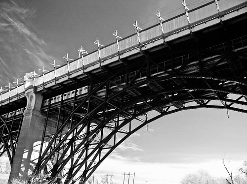
It wasn’t until 1918, when construction of the Prince Edward Viaduct (also known as the Bloor Steet Viaduct) was completed, that Riverdale became easily accessible to the rest of the city. At the time, it was nicknamed “the bridge to nowhere,” but it was also said to have brought about the “unification of Toronto.†Sprawl and intensification in the east followed.
Many bridges now cross the Don Valley, but that doesn’t mean that some Torontonians don’t still view Riverdale as the far east (the Beaches and all of Scarborough notwithstanding). A few friends of mine remain very impressed that I manage to bike to my office at Queen and Spadina every day in the summer. The daily trek I used to make from Dundas and Ossington to Jarvis Street (before I moved to a new home and workplace), which is about the same distance (maybe even a little longer) never elicited as many “wows†and “good for yous!†Other friends of mine who live in Parkdale often make quips about how far away I live from everything, though I’m much closer to Yonge and Dundas Square, which refers to itself as “the heart of the city,†than they are.
Most interesting was when I was taken to task for referring to the Toronto Film Studios on Eastern Avenue between Carlaw and Leslie as existing “downtown.†The film studios aren’t far from Queen Street East, whose shops and sidewalks aren’t any different from the rest of Queen (both west and east). Apart from the suburban-style grocery stores, fast-food joints, and big-box stores that have popped up closer to car-friendly Lake Shore Boulevard, the nearby neighbourhood to the north is dense, walkable, and full of amenities, a continuation of the streetscape that emanates from the business and fashion districts to the west. To me, Riverdale is as much downtown as are the Distillery District and the St. Lawrence neighbourhood just across the river (but less downtown than, say, Bay Street or Dundas Square). Today, the only curses you’ll hear from people trying to make their way home to Riverdale, will be from those of us stuck on a slow, packed streetcar.
photo by Metrix X
8 comments
I always thought that the Don Valley was the dividing line of Downtown (with Dufferin and Bloor being the other roadway boundaries). Where else would it be?
I always think of “downtown” as being the old city of Toronto. It’s a huge downtown, but the GTA is so big, it’s all relative, and for me, it’s downtown.
That could be a condition of having grown up in exurbia, where any place walkable was downtown.
But depending on the context, if I lived in Riverdale, Parkdale, Yonge and Eg or similar I would tell relatives in Brampton, Halifax and Windsor that “i live downtown” when they ask where I lived in Toronto. They know what that means.
Sean: I always thought so too. I’ve talked to some crazy west-enders though, and they believe that Yonge St is the “true” boundary, which I acknowledge as a mere formal boundary.
I don’t really think of where I live (Leslieville) to be “downtown” because when I think of “downtown”, it has a lot more crowds and it hustles and bustles. Negative connotations notwithstanding, I’d call it “inner city” to other core Torontonians.
Like Shawn, though, if I were talking to people outside of the GTA, “downtown” would do as shorthand.
I don’t think it’s an insane stretch … I’m only about a 5-10 minute drive away from the core.
Having grown up in the east end of Toronto (in a part that thankfully still defies having a trendy name being stuck on it) the Don Valley represented the boundary of downtown for our family. I had relatives living in the west end near Keele St. that we visited frequently, and to my parents Spadina represented the western boundary of downtown. We didn’t venture north on Yonge St. very often but I’ve always thought of Davenport Rd as the northern boundary. I hear people who live at Bloor & High Park say they live downtown. Uh, no.
Also, with regard to Riverdale being connected to the rest of the city, wasn’t the Queen St. bridge built well before the Prince Edward Viaduct?
I grew up in the depths of Scarborough (Morningside and Ellesmere, Markham and Sheppard) and vowed that when I had a place of my own I would never live in the suburbs. I wanted to live downtown.
To my Scarborough eyes, Riverdale is downtown.
If you read old Toronto Star editions from the mid to late 1880s, you’ll find the “easterly” news was confined to a small daily column called “Across the Don”, which detailed in very broad strokes what was happening in the area.
It’s interesting the way distance changes over time. People went for holiday retreats, away from the city, in The Beach.
Enjoyed reading your article. I’m an artist who just completed a whole series of works on the viaduct. You can check out my project online at http://www.marielugli.com/viaduct.htm
Cheers!