
Chicago is often referred to as Toronto’s closest sibling. Built in similar times, with similar sizes and populations, there are obvious similarities between the two. But we are by no means twins.
One of the most striking differences between the two are their street grids. Below, I’ve taken a few locations to illustrate the difference. All images are at the same scale and with Toronto rotated about 17 degrees (as commonly represented, with Toronto’s north border horizontal). Keep in mind that I have stripped the images down to show only the street grid.
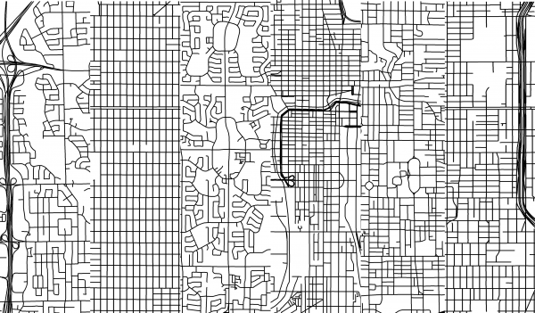
Case 1. Downtowns (Left – Downtown Toronto. Right – Downtown Chicago)
Toronto’s downtown grid looks pretty regular except that many of our east-west streets don’t continue through the city. (See Dylan Reid’s post “Toronto is not a grid“)
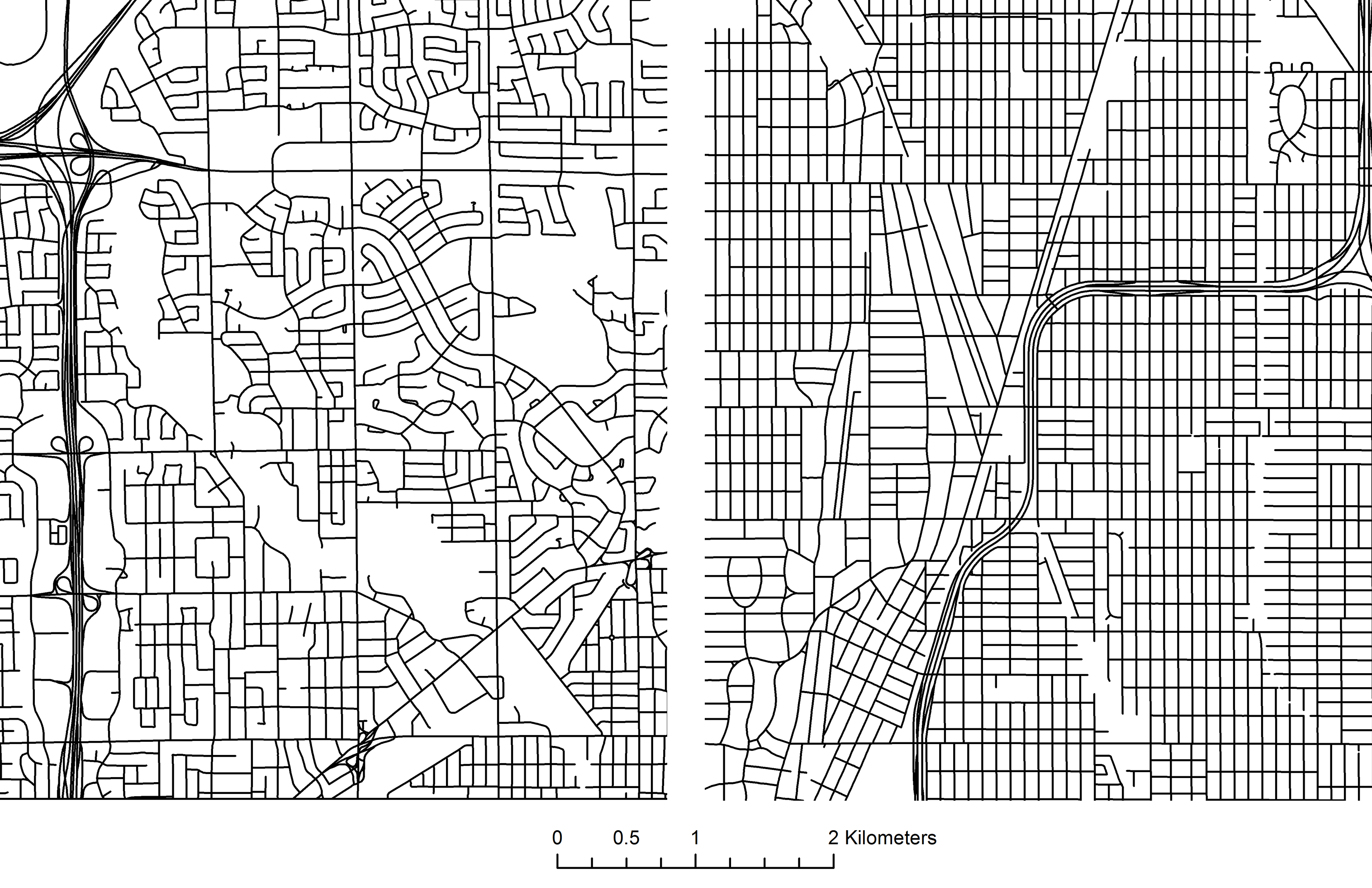
Case 2. Suburbs 1. (Left – Central Etobicoke. Right – South Chicago)
Toronto’s streets curl and curve, also accommodating Mimico Creek (the blank stretch) and Highway 427. Chicago’s seem to almost ignore the highway passing through.
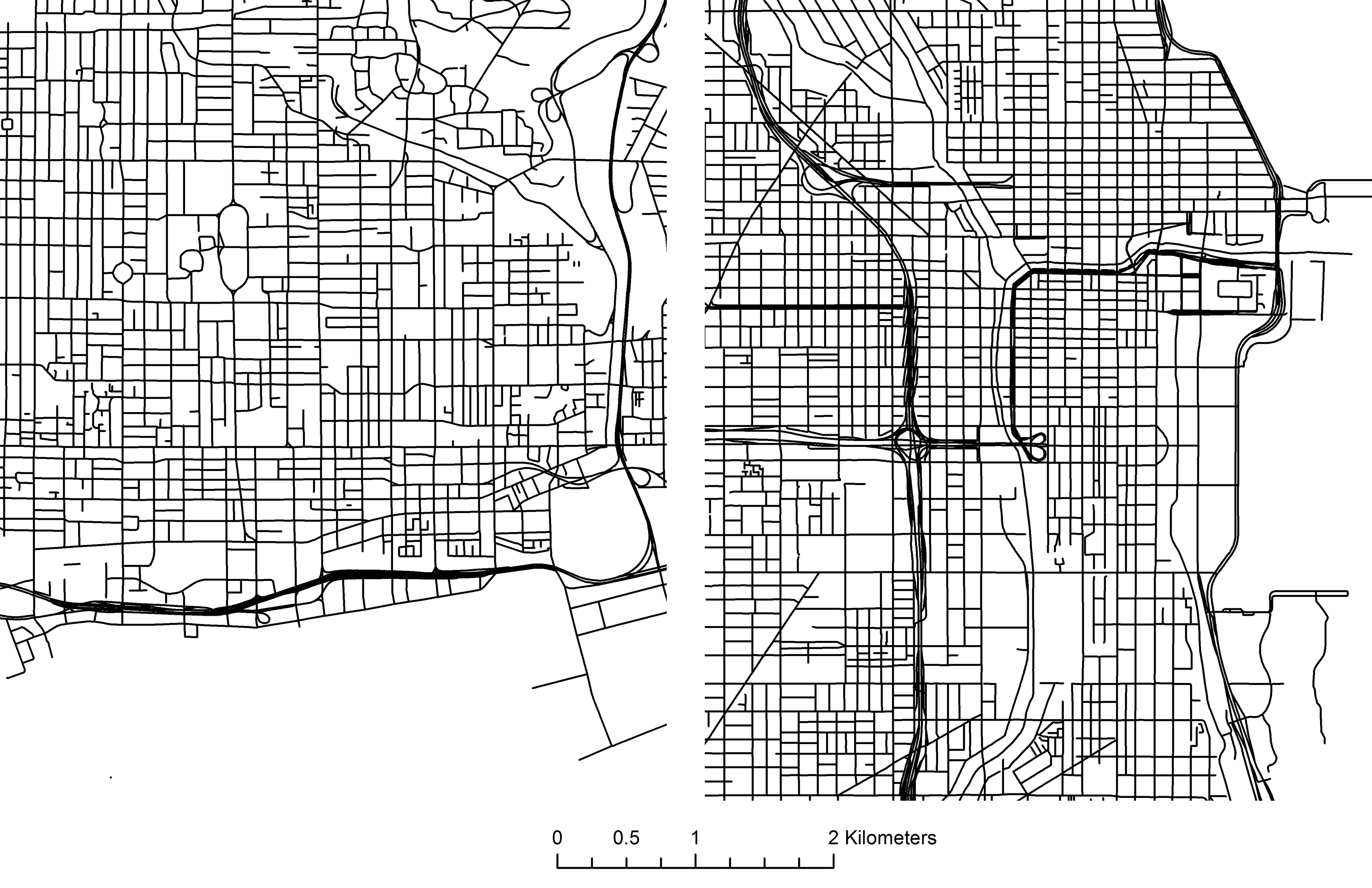
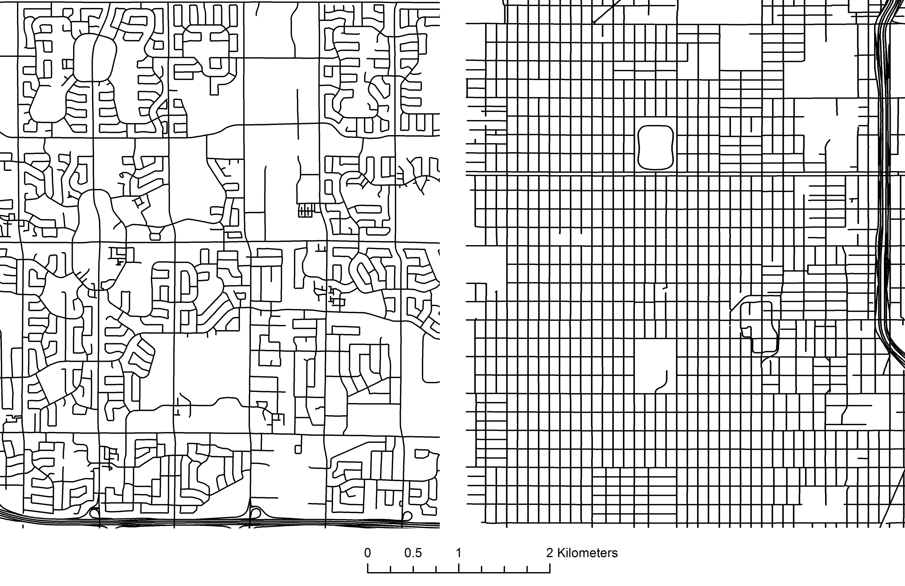
Case 3. Suburbs 2 (Left – North Scarborough. Right – Chicago’s West Side)
Toronto’s ring roads come out against a stark modern rational grid in Chicago.
A few things I noticed immediately:
1. Toronto’s grid listens to parks and ravines
One of our great assets is our ravines, and after Hurricane Hazel, we decided not to develop in flood plains. On top of this we have huge green spaces that cut through the grid and fill the city with greenery – the whole ‘city in a park’ moniker has a physical form. There’s almost a sense that open space morphed Toronto’s grid, while it seems more installed into Chicago’s.
2. We designed privacy and silence into our suburbs
The curly craziness that happens in Scarborough and Etobicoke are part of the design of our suburban communities – they were designed to keep traffic out. The streets are mazes, but they are oh-so-quiet. Scarborough and some parts of Etobicoke also have ring roads that surround shopping centres, schools and high rise housing surrounded by detached housing.
3. We wanted some separation from our expressways
Chicago depressed and embedded their expressways within communities while Toronto spaced them far away with big grassy buffers. Both probably have their pros and cons, but Toronto seems comfortable using green space liberally.
Different planning philosophies and circumstances led to the creation of different patterns of development. What is most interesting is that these grids are physical records of a variety of decisions that have accumulated over time. Do you notice anything else in these comparisons?
8 comments
Might also be interesting to rotate the grid for downtown Toronto (or Chicago) so you can see how the grids are oriented to the lake since we go N/S and they go E/W.
Actually now that you mention it, I did something like that a while ago: https://visualizingurbanfutures.wordpress.com/2013/04/24/chicagotoronto-chiconto-torongo/
Not quite as nuanced but still interesting!
Lived in both and visually this is pretty cool.
It’s hard to fully compare the grid vs. cul-de-sac and highway right-of-ways since Chicago’s big growth spurt was roughly from 1870 to 1950 (especially the parts of the city Sheraz looks like he pulled out) while Toronto’s has decidedly been since 1950.
This is, if anything, more an interesting contrast in the change in how cities were design and built between 1900 and 2000. If you go to further out suburban parts of Chicago, built up after 1950, you’ll see a grid much more like the chunks of Etobicoke and Scarborough here.
Echoing Dave’s comment: it’s hardly instructive to compare the slices of suburbia you’ve chosen. What the difference in street layouts between Scarborough and Etobicoke, on the one hand, and the areas of Chicago you’ve chosen as representative of suburbs, on the other, tells us at a glance is that they were laid out in completely different areas. Areas of Chicago like Morgan Park and Washington Heights (in your South Chicago grid) are late-19th-century railroad suburbs that were incorporated into the city of Chicago by the turn of the 20th century. I-57 was driven through these neighborhoods in the 1960s – part of a huge movement in US cities in that period. (And also in Toronto, though less extensively: cf. the battles fought by Jane Jacobs after she moved to the Annex.)
By contrast, though Scarborough and Etobicoke both have 19th-century towns at their core, the development you’re seeing in the cul-de-sacs you’ve illustrated is all from the latter half of the 20th century. You can test your impressions of what the street patterns are telling you from the air about period of development by dropping the Streetview man into these neighborhoods and having a look around. In Chicago, you have to go much farther out to get to the postwar suburbs that have the kind of curviness and self-isolation you’re seeing in Toronto’s exurbs.
As Dave suggests, the interesting question is why Toronto remained so compact for so long. The impression you’d get from the extent of prewar development in both cities was that Chicago was just a much, much bigger city in the late 19th-early 20th century. Population figures grabbed quickly from Wikipedia bear that out: Chicago had a million people already by 1890, and 3.4 million by the start of WWII. Toronto, on the other hand, had only 238k people by the turn of the 20th century and 900k by the start of WWII. That’s a huge part of the answer to why so much more of Chicago consists of neighborhoods with prewar street grids. Also, how much did the persistence of Toronto’s close-in suburbs as separate jurisdictions throughout the 20th century constrain or shape suburban/exurban development? Chicago was already annexing the towns around it before the 19th century was over, whereas Toronto’s amalgamation happened a century later.
(Sorry, said “laid out in completely different areas” when I meant completely different *periods*.
All great points. Dave put it well that this should be seen as a visual comparison of an certain era of development. Those eras produced (generally) forms that arose from a certain planning philosophy which each city must govern in its present-day form.
I tend to find the whole “Chicago and Toronto are similar” position flawed as both Cities are not at all similar after you establish that they are both situated on Great Lakes and both have similar populations (excluding adjacent jurisdictions). Thanks Dave and Carin for pointing out some of the important facts that provide context to the mapping.
Imagine if the side streets in Willowdale and Newtonbrook were infinite, and then you’d get Chicago.