
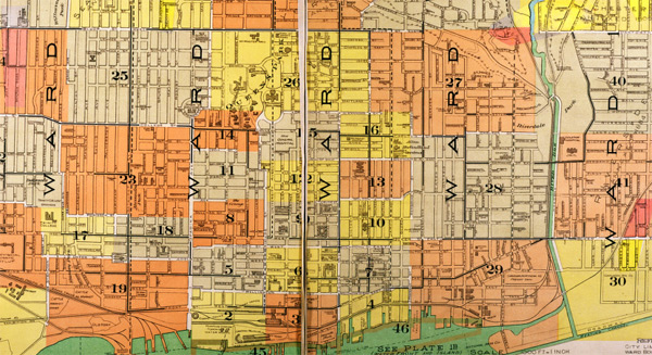

We usually think of Toronto — at least the older part of it — as being based on a grid of streets. One of the city’s free weekly newspapers even calls itself The Grid.
But Toronto’s streets are not in fact laid out in a true grid, and that has some significant implications for how we manage cycling routes and traffic.
Cities like Vancouver and New York have close to true grid layouts — that is, all of the streets, even the lesser ones, are continuous and parallel to each other.
What Toronto has, instead, is a series of mini-grids stitched together within a skeleton grid of arterial streets (the old concession roads). These mini-grids within concession blocks often don’t align with each other.
All over the older part of Toronto, if you are travelling on a side street, when you get to an arterial you’ll often find that the continuation of your street on the other side is off-set a little, or a lot, from the one you’re on.
As historian Richard White wrote in the Summer 2010 issue of Spacing, these off-set streets are the result of early landowners developing their land grants each in their own way. Once the car started to become dominant, the City embarked on a “jog elimination” program to stitch some of these streets together more continuously — a process that gave us, for example, the length of Dundas St., extended eastwards by stitching together many older east-west streets. But only a relatively small number of jog eliminations were ever completed (examples cyclists may be familiar with are the connections between Beverly and St. George, or Hoskin and Harbord).
When you add to these off-set streets railway lines, ravines, parks and other interventions, the result is that few side-streets in even the older parts of Toronto extend for more than a few kilometers. (And once you get to the post-war suburbs, all street continuity is deliberately lost for side-streets).
This irregularity has implications for Toronto’s cycling network. Politicians and others occasionally claim that Toronto’s cycling network should avoid arterials and be based on side streets — a solution common, for example, in Vancouver. But, unlike Vancouver, Toronto does not have side streets that continuously parallel its main streets. Where there are reasonably extended side-streets, they are indeed used by cyclists (for example, Shaw or Logan). But for the most part, to travel any great distance in a reasonably straight line, the only solution for cyclists in Toronto, as for cars and surface transit, is to travel along main streets. That’s why we need to focus on a complete streets policy to enable all modes to use these main streets together.
Incidentally, the lack of a true grid also explains why it’s more difficult to create a network of one-way main streets in Toronto similar to that in Manhattan. There simply are not a lot of situations where there are parallel, adjacent main streets of similar size for any great distance — the only examples are restricted to the city’s core.
Image from City of Toronto Archives
5 comments
Glad you could catch up to this concept, and publicize it. It is a HUGE problem to get us to even a single, straight-ish, safe, smooth east-west route in the core and it’s soo old that it was obliquely noted in the 2001 Bike Plan. There has been an obvious solution, Bloor, from before that time (c. 1992 actually with the first study of where to put E/W bike routes) as Bloor is the most readily changed over to improve bike safety, since the street does not have any streetcar tracks due to the subway. Streetcar tracks are basically permanent obstacles to simply and cheaply repainting the few direct roads that exist, unless one somehow takes a curb lane for a bi-directional bike lane, less safe due to the many short blocks that intersect these main roads.
There’s been a focussed effort to improve biking on Bloor, with some initial success c. 8 years ago with getting Council approval for a study of it in the core, but time passed, etc., and while we wound up getting to a point of a signed contract for a good EA study of it all in the last few months of the Miller regime, Fordists undid it all in a 26 to 19 vote and that was two years ago, and we have been removing bike lanes since as the core is usually completely dominated by the suburban rumps. Just a couple of months ago, Councillor Layton did manage to get all core councillors to agree to ask for a study – resounding applause!! – but the suburban rump of MW, Berardinetti, Grimes and Parker would only refer it to staff to see if it’s worthwhile to do, as studies cost money but subways don’t, right, (especially when you don’t study them)?
Meanwhile, Bloor St. W., likely the most logical place in Southern Ontario for a bike lane with the subway and the off-street parking atop it, is being repaved soon starting west of Bathurst over to Lansdowne, without an EA it seems, and without reference to the Places to Grow Act either, which theoretically mandates improvements to roads etc. to sustainable modes etc. The most critical link is from Ossington to Dundas St. W. as the grid is truly deficient and there aren’t really other options, apart from sidewalks, which some of us don’t want to do.
They’ve heard from me…. and don’t forget the provincial level either, they Must! begin to enforce their legislation.
And the side streets are usually a maze of one-way restrictions, which in the 1950s and 1960s had the well-intentioned goal of discouraging through motor traffic through local neighbourhoods but as utilitarian cycling became more popular, they make staying off those major roads more difficult. Of course one-way signs are ignored almost as much as stop signs. A street like Brunswick Avenue could be a useful north-south bike route from College to Barton/Lowther; it has lights to cross Harbord and Bloor. Contraflows are great, but a simpler solution might be to make those streets one way for motorists and two-way for pedal cyclists with “no turns – cyclists excepted” and “do not enter – cyclists excepted” signs. It’s be safer and more pleasant than the alternatives of navigating the maze, going the wrong way, or sticking to the main streets.
That’s quite helpful Dylan. That explains why it looks somewhat rational but it’s not. It’s still unclear why the blocks in old Toronto are so long and rectangular rather than square. It means there are many more minor streets north/south than east/west.
Herb,
The explanation for the long narrow rectangles is actually very simple – when the area was first surveyed for farms, Queen St frontage was very valuable so they were surveyed out to be very long, but narrow. The typical “park lot”, as it was called, extended from Queen all the way to Bloor, but wasn’t more than a couple hundred feet wide . When those lots were allocated, a second row from Bloor to St Clair was surveyed, then a third. North of Eglinton the frontage 90 degrees to face Yonge street. This pattern of deep farm lots with narrow frontages is still apparent in undeveloped parts of York Region (again, fronting Yonge St or parallels), and much of the rest of Southern Ontario, today.
When they were subsequently developed each of these lots was developed piecemeal, and the roads built in the most logical form – a couple of parallel rows of houses facing streets running the length of the grant, with cross streets often random and discontinuous between developments, and sometimes added later.
Every city in the world has a grid. I don’t think there’s any other word for the pattern of streets in a city from a map/aerial view. A few North American cities like New York (and not Toronto) are the only ones with a near-perfect grid where most of the streets are long and continuous and always intersect at 90 degree angles. This idea dates back to Georgian times and was more feasible in new colonial cities than in older European cities where the grid was inherited from medieval times. (Nonetheless, most European cities demolished a lost of their medieval past by the times of Baroque for straight, wide avenues to strengthen the authority of the new wave of absolute monarchs.)