As many people may know, transit-oriented development (TOD) is emerging as a popular and influential planning idea across North American cities as a means of sustainable urban development. TOD is defined as moderate to high-density, mixed-use residential and commercial development located around a transit station or corridor. Representing the full integration of land use and transportation planning, it encourages a compact and pedestrian-oriented form where people are able to live, work and play in the same community.
Given concerns of increasing urban sprawl and high ecological footprints, pursuing TOD has proven to be an effective way of concentrating growth on brownfields while generating and attracting transit ridership to shift mode share.
In the City of Vancouver, the SkyTrain rapid transit system has shaped land use planning since its inception in 1985. While development that capitalizes on rapid transit has been successful in the downtown core, a simple ride on the train will clearly show that the stations beyond the peninsula have yet to pursue transit-oriented development to its full potential.
With Vancouver’s projected population increase from about 578,041 in 2006 to 740,000 by 2041, it seems natural to concentrate future growth along transit corridors where surrounding neighbourhoods within station catchment areas would be able to benefit from a more complete and intense mix of residential, retail, office and community.
Of course, this is often met with apprehension by the communities directly affected by such transformations. However, prioritizing densification along transit corridors can, and should, be done while preserving neighbourhood character within outlying single-family zoned districts. Successful climate change planning must consider the interest of the city at large and be contingent on the geographical circumstance.
For example, high density development in a neighbourhood such as Dunbar would be unsuccessful in the short-term as there would be no existing locational advantage of being close to rapid transit. Concentrating resources towards creating successful TODs will serve as useful precedents to deepen public acceptance of more sustainable urban forms, especially given that concerns regarding neighbourhood character preservation often run high in single-family districts.
At the larger scale, as automobile dependency decreases and transit ridership increases, the development of TOD along transit corridors make sustainable mode share and greenhouse gas reduction targets at the provincial (2007 BC Greenhouse Gas Reductions Target Act), regional (1999 GVRD Livable Region Strategic Plan) and municipal level (1997 Transportation Plan, Greenest City 2020 Action Plan) more attainable. Given the latter, assessing potential areas to improve and/or optimize TOD in the city is becoming increasingly important for long-term planning.
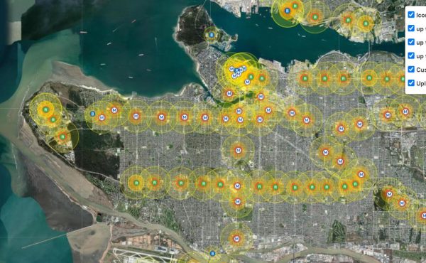
Towards this end, a multi-criteria evaluation (MCE) was conducted to assess TOD performance in the City of Vancouver and identify potential SkyTrain station catchment areas within a proximity of 400, 600 and 800 meters that would benefit from intensifying and optimizing TOD.
The MCE method is useful to decision-making since it is able to evaluate multiple and often conflicting criteria. Done in conjunction with the use of a Geographic Information System (GIS), it can accommodate large amounts of information and provide a structured, traceable and flexible analysis: making a multi-criteria evaluation an effective spatial decision support tool in a multi-stakeholder environment. The models created can then be used by planners, politicians and the public in determining ideal solutions to regional, city, neighbourhood and community problems.
For the purposes of my study, six criteria were selected. Four criteria were used from Statistics Canada’s 2006 Census: population aged 15 to 24, household income less than $40,000, recent immigrants from 1996 to 2006 and low density housing (primarily single-detached). The fifth criteria was walkability derived from an index developed by Larry Frank and his team at the UBC Health and Community Design Lab. Similarly, the final criteria was bikeability developed by Meghan Winters and her team at the UBC Cycling in Cities research program.
These criteria were selected to capture the social and physical dimensions of an ideal TOD.
The 15 to 24 age group represents the most likely group to travel using sustainable modes. In Canada, 35.1% of this group across all major census metropolitan areas use sustainable transportation to travel to work. In Vancouver, they represents 36.7%. Similarly, recent immigrants are more likely to use public transit, even after controlling for demographic characteristics, income, commute distance and residential distance from the city centre.
While TOD can be expensive to develop and generates a high demand and real estate value, it is very important to ensure future transit-oriented developments in Vancouver are equitable and within reach of lower income households. As such, households that have an income of less than $40,000 – an approximate threshold for Vancouver’s living wage of $18/hour – were chosen. Station catchment areas that have a higher proportion of these census groups have a higher potential for TOD intensification.
Single-detached family dwellings are characteristic of undesirable land use patterns in a transit-oriented development due to the fact that they are typically low density and unable to support a cost-effective transit ridership rate. As classified by Statistics Canada, the presence of high proportions of seven housing types are favourable for TOD intensification:
- Single-detached,
- Semi-detached,
- Row house,
- Apartment – duplex,
- Apartment – fewer than five storeys (includes single-detached homes with secondary suites),
- Other single-attached, and
- Movable dwellings.
Statistics Canada’s eighth housing type, apartment – five or more storeys, was excluded as it satisfied the requirements of an ideal TOD for this study.
Lastly, because transit-oriented development is intended to promote sustainable transportation modes like walking, biking, and transit, one must ensure these types of transformations will increase the walkability and bikeability of communities along transit corridors. Areas that have low walkability and bikeability are considered favourable for TOD intensification.
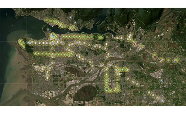
With this in mind, ten stations that have high TOD intensification potential were identified. These are shown in the graphic above. They are represented in the headline image above: Commercial-Broadway, Nanaimo, 29th Avenue, Joyce-Collingwood (Expo Line), VCC-Clark, Renfrew, Rupert (Millenium Line), Oakridge-41st Avenue, Langara-49th Avenue, and Marine Drive (Canada Line). While the results align with expectations, they are useful as a visual and quantitative assessment of TOD performance in Vancouver and may validate controversial community plans.
For Expo Line stations, given that Nanaimo and 29th Avenue opened in 1985, much can be done in this area to encourage TOD such as incremental rezoning from single-family to multiple residential dwelling and commercial over time. These stations catchment areas are more characteristic of transit-adjacent development — conventional automobile-oriented development located near transit stations.
The station that had the highest potential was Marine Drive near the border between Vancouver and Richmond. Consequently, the City recently passed the Cambie Corridor Plan in early 2011 that includes a coordinated planning strategy for the entire corridor. According to the City, it will “integrate development with transit along and around the Canada Line to support the City’s goals of environmental sustainability, livability and affordability. [It will] emphasize walking and cycling trips, especially those integrated with transit.” The plan presents a valuable opportunity to optimize the new Canada Line stations for TOD.
As one can see, Geographic Information Systems are a useful tool in guiding planning and policy decisions shaping long-term land use and transportation. Offering transparency in analyses conducted by local governments may lend support from the public and assist in making evidence-based planning decisions. Implementing public participation GIS can also improve the public process, with potential for increased community participation.
Local knowledge is just as vital in shaping communities and GIS can be adopted for community use as a form of community empowerment. However, its specialized nature is a major barrier. As a word of caution, these results are an ideal reality and it is important to realize using GIS only constitutes one aspect of planning for people.
***
Victor Ngo is an undergraduate student studying Geography and Urban Studies at the University of British Columbia. This article was the result of a final project for an advanced GIS class. The full academic paper will be appearing in Trail Six, UBC Geography’s peer-reviewed journal and will be presented at the 2012 Annual Meeting for the Western Division, Canadian Association of Geographers in Kelowna this March.


10 comments
Useful analysis. Thanks.
But… the reddest area immediately southeast of Joyce station is already intensified.
I don’t really understand how the current demographics of the station area is relevant to determining how appropriate the area is for densification. Densification means bringing in more people, who won’t necessarily share the demographic profile of the people who already live there.
More to the point, if you’re going to densify the neighbourhood, you’re going to demolish the existing houses and the people who live in them (income below $40,000, aged 15-24, new immigrants) are going to have to move out of their demolished houses and in a couple of years they’ll be replaced by the kind of people who can afford to live in new construction (income over $40,000, not aged 15-24 and for the most part, not recent immigrants).
On a more nitpicky note, why do urban geographers always use circles to indicate walking distances from transit stations? People don’t walk as the crow flies, across their neighbours’ back yards, through houses and across freeways. Can’t geographers look at street layouts, pathways and pedestrian barriers, and come up with realistic walking distances? Surely a good GIS could automate this function.
Just a small correction. You said:
‘With Metro Vancouver’s projected population increase from about 578,041 in 2006 to 740,000 by 2041…’
Those sound like the figures for the city of Vancouver proper, not Metro Vancouver.
Victor,
Thanks for the thoughts on the local application of TOD. I think you mean “Vancouver’s population will increase” to 740k by 2041. The population of the Region is expected to expand by 1.2 million by 2041 according to the Regional Growth Strategy.
Victor, congrats on your analysis and your work on this! Nice job!
Thanks, Dominic….I think you’re right.
E
Jarek,
Thanks for pointing that out. It’s important to consider the limitations of GIS, how the MCE is conducted, how the data is modelled, and the particular set of criteria you use when interpreting the results. Using a different weighting scheme where everything is considered equal, that particular red block ranks more moderate. While there is no low density housing there (it scored 0), it did score low for walkability. However, it does rank higher for the age, income and immigration which accounts for the higher potential. I used a simple addition equation (criteria 1 + criteria 2 + …) for the MCE, but there are more complex methods that would be able to accommodate for this.
Also, an inherent problem to any geographic analysis is the geographic unit used. It becomes a more technical discussion, but I refer to the “modifiable areal unit problem” here. Because I used census data, the way the analysis is run and presented is “limited” by the dissemination area. A more appropriate method may be to run the analysis at the parcel level, or have a single value representing the TOD potential for each walking radius (which conceptually makes more sense). Unfortunately, the data doesn’t exist to do that.
With that in mind, the important takeaway from the results is to get a general sense of TOD potential, and not be concerned with the specific, fine scale results. This suggests that despite Collingwood Village being a TOD (which the majority of it is not represented on the map since the DA it falls under was suppressed by Statistics Canada), immediately surrounding it are large swaths of single-family homes.
Ben,
Ideally, I believe there should not be substantial displacement of those existing demographics I identified, hence why I briefly mention equity concerns with TOD. Again, I’m interested in capturing the social and physical dimensions of an ideal TOD. A much richer discussion on the issue of equity is available in the full paper which I unfortunately had to cut due to lack of space. Specifically, I cite an article by Nicole Foth (2010). Long-term change around SkyTrain stations in Vancouver, Canada: A demographic shift-share analysis. The Geographical Bulletin, 51: 37-52.
And regarding circles, yes, you are absolutely correct. Using a circle to model walking distance is not truly representative in an urban grid. Using circles are common for a variety of GIS analyses in different fields, such as resource management, when you’re interested in creating buffers around points, lines or areas of interest. I believe this is more out of convention as it’s the default geometry provided in many GIS packages. Other geometries (square, hexagons, etc.) require more work in the software and the appropriate data that allow you to consider the parameters you mentioned, adding complexity. I used ESRI ArcGIS for this analysis; I simply specified 400, 600 and 800 m buffers and it took a few seconds to process. Jarrett Walker had thoughtful posts on this so take a look in these two posts:
http://www.humantransit.org/2011/04/basics-walking-distance-to-transit.html
http://www.humantransit.org/2010/05/culdesac-hell-and-the-radius-of-demand.html
Thank you for mentioning it. I will consider your suggestion for future analyses.
One addition for my comment in how to interpret the results. Consider the general sense of TOD in the walking radiuses, and don’t spend too much time analyzing the individual fine-scale results inside. This is why I chose not to present a table of exact TOD potential values for each station as it would not be very meaningful information.
Interesting article (especially when you consider what we are dealing with in Toronto) on how go connect transit and land use planning.
What seems to be missing on a systemic basis is a more complex set of options for the land use side of the equation. People don’t just need to live near transit, transit needs to serve the cultural, educational, and commercial dynamics of cities.
The persistent focus on residential density forgets that if we create complete communities, with mixed neighbourhoods consisting of more complex development, people won’t require a train or a care or even a bike to get around, they will, more often than not, already be where they need to be.
Bad land use and transit planning which far to often segregates retail,commercial,residential,institutional and every other urban use of property. It also amplifies demand for transit across greater and greater distances. We need to back to the future and examine how cities evolved before planning and cities became so scientific.
Older neighborhoods deliver an eclectic and chaotic mix of land use effortlessly, the effort to retrofit newer neighborhoods is expensive and often results in artificial (new) urbanism. The cost and waste of segregated new urbanism from an economic standpoint is also questionable. It certainly delivers an enemic tax base.
When existing transit lines are looked at, perhaps desolate nodes should be zoned with a mandatory “mixed” designation. If new heights or densities are desired, existing demographic and land use patterns should be replicated, instead of simply pursuing equally simplistic (ie point tower style condo projects) real estate models.
The goal of densification should be vertical neighborhoods, more mix, not just more buildings and more people.
To keep it simple, make it more complex.