
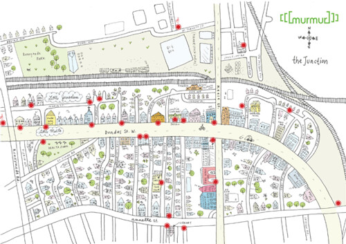
[murmur] is pleased to announce we have launched our latest project in Toronto’s Junction neighbourhood as part of this weekend’s Junction Arts Festival. We have installed 27 listening posts — those familiar green ears — throughout the neighbourhood (download and print out the map of locations here) with over 80 stories spread among them. More locations will be added in the coming weeks.
This [murmur] was commissioned as the legacy project of the Junction Arts Festival — itself in its 16th year — to celebrate the 100th anniversary of the Junction City. Check out their site for details and schedules, or just head to the neighbourhood anytime this weekend as Dundas will be closed from Keele to Quebec Avenues and filled with art, installations and performances.
A special thanks to all our volunteer story collectors who scoured the streets looking for brains to pick (and record) and to Tania Howells who drew the fabulous new Junction map above.

5 comments
so glad it all worked out well!
thanks for the linkage!
It’s terrific that the map includes Runnymede park and the areas north of the Canadian Pacific railway which were historically part of West Toronto, and should still be included in any map of the Junction.
That’s a wonderful map that Tania drew. Every neighbourhood should have a community map.
One can argue that the Junction extends further south almost to Bloor according to City maps from the late 1800’s.
Actually the section NE of the tracks technically should be included, which basically sits right next to the crossing of the tracks that the ‘hood has derived it’s name from. Bloor Street is too far south to be included, but I suppose the map was really more for promoting the art festival which is centred on Dundas West/Keele.