
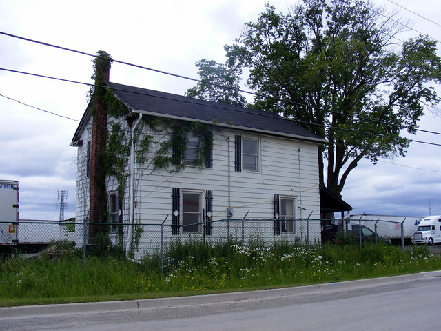
Former residential building on Codlin Crescent, possibly an old toll house on the old Albion Plank Road. Today it serves as the office of a truck yard.

Located in the northwest corner of the City of Toronto sits the all-but- forgotten hamlet of Claireville. Surrounded by busy highways, a major freight railway and conservation lands, it is the most isolated of Toronto’s lost villages. At the farthest northwest corner of the city, the only regular transit service through here is provided by Brampton Transit; the TTC’s buses stop just short of this historical community.
Settled in the 1830s, the settlement was formed at the corner of three townships: Etobicoke, Vaughan and Toronto Gore. It is one of several settlements along Albion Road, just a few kilometres from Thistletown.
Albion Road was one of the first settlement roads surveyed outward from the old Town of York dating back as early as 1799. It remained a very important farm-to-market route, especially before the railways were built in the area in the mid- and late-19th century. In the late-1840s, the Albion Road Company was formed by several local businessmen, the road was planked from Weston to Bolton, and tolls instituted. Toll houses lined the route in each settlement, charging for each traveler, horse, and head of livestock passing through.
The location, at the corner of the three townships, was first known simply as Humber (being adjacent to the West Humber River). A tavern was opened in 1832. But in the 1850s, a local landowner, Jean du Petitpont De La Haye, created a town plan and renamed the settlement for his eldest daughter, Claire. De La Haye was an immigrant from France and was a faculty member at Upper Canada College. He was one of the Albion Road Company backers so it was hoped that the improved road would promote the establishment of a sizable community (and those residents, naturally, would make use of the road).
The Grand Trunk Railway, built in the 1850s, served the nearby hamlet of Malton on its Toronto-Chicago mainline. That settlement, boosted by the railway’s presence, grew to attain the status of police village before being amalgamated into the Town of Mississauga in 1968. In 1871, the Toronto, Grey and Bruce (TGB) built a line from Toronto to Orangeville (and points beyond) through Emery and Woodbridge, passing far from Claireville to the north and east.
However, Albion Road still held some importance, so Claireville did not disappear unlike some early vanished villages. In 1877, it boaswst several churches and businesses and 175 residents. In the 1930s, Albion Road was designated as Highway 50 to connect Toronto with Bolton and Alliston. By the 1960s, Indian Line — the boundary between Toronto Gore and Etobicoke Townships — had also increased in importance as it became the shortcut to the new Highway 427 and Malton Airport from the north. The railway eventually came to Claireville, but that was not until the early 1960s as CN’s Toronto freight bypass.
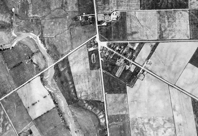
1947 aerial photo of Claireville. Albion Road runs diagonal south of Steeles and then northwards to Bolton. Steeles jogs, and Indian Line runs south along the Etobicoke-Toronto Gore township line. The West Humber is visible to the west of the hamlet. Image from the Toronto Archives online collection.
The village declined in the early- and mid-20th century. An aerial photograph from 1947 shows fewer than 20 houses; by the 1970s, only one church, a general store and the community hall remained as local amenities; all were gone by the 1990s.
Toronto’s sprawl did not reach Clairevile until the late 1970s, but by then it was cut off by the CN bypass to the south and the municipal boundaries on the west and north sides. Toronto Gore Township was amalgamated into the new cities of Mississauga and Brampton. It is here that Brampton and Toronto share a short common boundary.
Codlin Crescent incorporates the old alignments of Albion Road, on the right, and Steeles Avenue, on the left.
The realignment of Albion Road and Steeles Avenue, constructed in the 1970s, bypassed the original settlement; Codlin Crescent incorporates both of their former alignments. This realignment straightened the intersection of Albion and Steeles while preserving the few remaining houses. But with no through traffic, Claireville retains its rather forgotten appearance, a minor curiosity for motorists passing on Steeles or Albion. Heritage Toronto suggests that building in the photo at the top of this article, a house at 2095 Codlin, was likely an old toll house for the Albion Plank Road.
Then in the 1990s, Highway 427 was extended from Finch Avenue to Highway 7. Indian Line was closed for good and this lonely corner of Toronto became even more isolated. Interestingly, the old route to Highway 427 has been left alone, including the railway overpass. Only the road signage has been removed, even the intersection with Albion Road remains intact apart from the removal of the traffic signals.
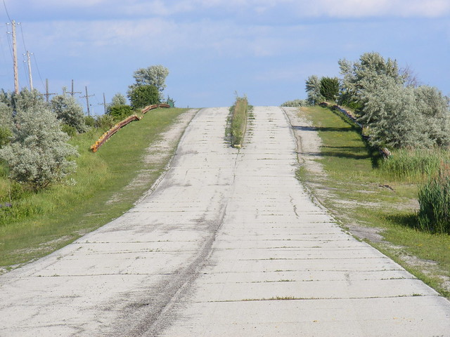
Abandoned roadbed of Indian Line over the CN bypass, the former terminus of Highway 427.
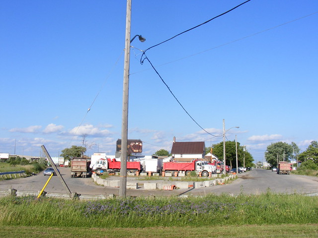
I found Claireville to be, by far, the most depressing of the various lost villages that I witten about for Spacing over the last year or so. It lacks even a touch of charm found in places like Meadowvale, West Hill or Churchville, or even the historical curiosity of Barbertown. Today, the former settlement has largely become a truck parking lot, with a few holdout houses. Apart from the old toll house (which lacks any tell-tale features), the only feature of interest is the abandoned Indian Line roadway. Today, the busy intersection of Albion and Steeles lacks even the common trappings of its suburban peers, without even a gas station or coffee shop.
Claireville lent its name to the large Claireville Conservation Area, which stretches several kilometres into Brampton and the associated reservoir and flood-control dam on the West Humber, also managed by the Toronto Region Conservation Authority. On the far side of the reservoir are the Indian Line Campground and Wild Water Kingdom, both parts of the conservation area, the latter a long-term lease of TRCA’s lands.

3 comments
Wow, forget places like Chibougamau or Flin Flon. This place really has a hopeless “end of the world feel” to it, probably because you know it exists within the confines of the country’s biggest city, so our obliviousness to its existence is on a much more personal municipal rather than national scale. I guess an equivalent would be those sad neighbourhoods on the southeastern edge of Chicago near the Gary, Indiana border.
I remember this area well having grown-up in Malton and often visiting cousins (over that abandoned bridge) just north of Claireville at the Gore Road & Hwy 7. I also camped more than a few times in Claireville Conservation Area and as a kid would even swim in Claireville Resevoir. The actual hamlet is truly frozen in time, but not a good time, and oblivious to city around it. Definitely one of the more depressing Lost Villages.
I was born and raised in Claireville, in the house directly west of the “toll house”. We moved from there in the mid-70’s but I spent much of my life roaming the area on horseback, and have many memories of the Supertest station run by Gertie Kitchener, I kept my horse at Watson’s farm by the train track, went to the opening of the Humber Dam, and spent many a day at Tinker Cleaners as well. Would love to see more old photos and especially the old church that was in the center of town. It was demolished sometime in the early 70’s. Thanks for the great stories and photos!