
This is the second post for Spacing Toronto exploring the Toronto Islands as the potent place that they are to our city. New posts will go up on Sundays and will discuss how Toronto and the Island have shaped each other in imagination, in reality, across time, place, and space.
The first Sunday on the Island explored how the sandspit that would become today’s Toronto Islands came into being and pointed out that locals have been calling that same land “the Island” since the early 1800s, far before it truly was an island — building the lack of accessibility of the place into its common name and framing the Island as a special destination for the people of what was then York.
The Island did not officially become an island until the Spring of 1858. In today’s post we will discuss the events surrounding ‘the breach,’ as it was called, and the role that Torontonians played in bringing the Island’s local name and the geography of the place itself closer together.
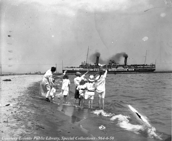
The story of the Island’s moment of decisive transformation into an island is a tale of disaster and survival. On April 14, 1858 a catastrophic storm flooded the section of the peninsula holding the newly-renovated Quinn’s Hotel. The hotel was so newly renovated that there was a party planned by Quinn and his family to thank the workers who had just completed the job. The waves from stormy Lake Ontario hit the ‘narrows’ of the peninsula, sucking the land away into the lake in a matter of hours (luckily everyone involved escaped permanent harm but it was a close one; the building was entirely demolished. A more detailed account in the words of Quinn’s daughter can be found in Sally Gibson’s More Than an Island).
Lesser-known is the prequel to the spectacle of the breach, taking place in the 1830s and 1840s and starring well-to-do lobbyists, anxious city councilmen, and opportunistic contractors (including Joseph Bloor[e] of Bloor St. fame).
Whether or not the Island would actually become an island had been preoccupying citizens of the city for long before the breach occurred. In 1835, just one year after the incorporation of the City of Toronto, a group of citizens hatched a plan to cut a canal through the peninsula. The canal would act as drainage for the sewage that was starting to overwhelm Toronto’s harbour (“noxious stuff” according to the Royal Engineer that they hired to draw up the plan). The canal would also provide a new, more convenient entrance to the harbour for ships sailing from the east, an important detail in a time when the city’s true downtown was mostly east of Yonge Street. Captain Richard H Bonnycastle and Thomas Roy presented their plan to the city but nothing was done regarding the proposal despite the considerable social influence wielded by “The Friends of the Cut”.

In her book More Than an Island, Sally Gibson discusses the excavation of loads of sand from the peninsula that was occurring during and after the late 1830s. The sand was being used to manufacture the novelty of Toronto’s first brick-based building boom. This independent sourcing was not always easy. Gibson relates the story of how, one winter, the contractor Joseph Bloor lost a team of horses through the ice on Lake Ontario as they were coming back from the peninsula pulling a heavy load of newly-dug sand. Pretty soon the City of Toronto, while slow to act on the earlier proposal for the Cut, took notice. The pell-mell removal of the land separating Toronto’s Bay and the lake was enough to force the City to return to the question of whether the Island should really become an island. In 1843, the City of Toronto formed a committee mandated to investigate the “extensive excavations” that had been observed on the peninsula. According to the report produced, in two places on the peninsula the sand separating the lake and the harbour had “almost entirely been removed… [This would be] seriously injurious to the Safety and value of the Bay.” The committee’s immediate recommendation was that the city post signs forbidding the excavations (which did about as much good then as it would do now: excavations continued on into the 1850s and Gibson speculates that the sand likely went into the infill for the Esplanade).
It wasn’t long after that Quinn’s Hotel and the land beneath it succumbed to the April storm.
The history of the question of whether to sever or reinforce the peninsula shows something of how the Island has always been a part of Toronto as much as it is apart from Toronto. The land’s physical form and the changes made to it were a source of great anxiety to many but others saw a potential solution to issues of pollution and transportation. The blurring of the line between peninsula and island was the work of Torontonians, but the line finally became clearer after the events of April 14, 1858. The Island was now an island, though the usefulness of the new breach was debatable. In another Sunday on the Island, the breach is turned into the Eastern Gap with considerable expense, the Island enters the era of dredging and sand-pumps and the Islander identity begins to come into its own.

3 comments
It should be remembered that the sand that created the islands (and the sandbar in front of Grenadier Pond) came from the Scarborough Bluffs. Unfortunately, these days the Leslie Split is deflecting the lake currents that could erode the islands instead of building it up.
Very true. A detailed description of the sand’s travels can be found in the first Sunday on the Island: https://spacing.ca/toronto/2012/06/24/sunday-on-the-island1/. A post discussing the Leslie St. Spit and its effect on the Island is planned for another Sunday on the Island and will discuss current efforts by TCA to protect the Island as it is. I didn’t know about the sandbar by Grenadier Pond – very interesting!
The sandbar in front of Grenadier Pond (and Catfish Pond in High Park) was narrower. The sandbar originally held only a two-track railway and a two-lane Lake Shore Road, and that’s it. High Park ended at the railway tracks with marshes. The city dumped sand and fill to greatly increase the land for a large beach, parkland and an amusement park, but the car soon took that over.