
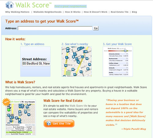
In the fall, I stumbled across an interesting web site called Walk Score dedicated to rating the walkability of neighbourhoods. Originally, it was only available for American users but it recently added Canadian cities. So I tried it out.
It compiles the location of specific types of amenities in your neighbourhood (grocery stores, bars, cafés, restaurants, parks, fitness, bookstores, libraries, hardware stores, etc.) and measures how far away they are. The lower the distance, the better the score. What it doesn’t rate is urban/pedestrian design, block lengths, and accessibility to public transit (!). All the locations and amenities are culled from Google Maps API.
The score assigned to your entry is out of 100. Anywhere between 0 and 50 is a non-walkable/must drive neighbourhood. A score between 51 to 70 is considered somewhat walkable area but a person needs a vehicle for some errands; 71 to 90 is very walkable, while 91 to 100 is considered a walker’s paradise.
I tried it out for a few of the places I have lived. My current place in Parkdale scored a 45. My first apartment in the Annex, one block south and east of Spadina and Dupont, scored 57. My former Bloor and Dufferin apartment (and I mean right above the subway station) scored only a 65. Spacing’s office, located just north of Queen St. West on Spainda, scored a measly 72.
Sadly, these scores don’t reflect my real life experiences of walking, living and working in these neighbourhoods. My Parkdale place is quite walkable, with many amenities nearby, yet it scored in the “for most errands, driving or public transportation is a must” category. Spacing’s office should be considered a walker’s dream come true with locations of everything within a 2 minute walk, yet it is ranked in the “it’s possible to get by without owning a car” category.
Besides not including public transit as an important walkability indicator, these criticisms are not necessarily the fault of Walk Score. Instead, the lack of information on amenities inputted into Google Maps limits the effectiveness of what could be a very valuable web-based resource for residents, businesses, and those searching to buy or rent a new home. This is a shame since this site has the potential to be one of the best publicly available tools to gauge whether our cities are as pedestrian-friendly as possible.

27 comments
Although interesting as a novelty item, it is pretty worthless given how much is missed. For instance, I live in Cabbagetown, and my score was 68.
How much higher would it be if it recognized that I live a 45 second walk from No Frills (which it doesn’t list)? Or a 40 second walk to Shoppers Drug (which it doesn’t list)? Or a block from Jet Fuel (which it doesn’t list)? Or a block from the Parliament Library (which it doesn’t list; instead, it *does* list the College Shaw Library, but at 4.5 km away; the Riverdale and St. Jamestown libraries are about a 10 minute walk in opposite directions, but neither show up either).
It is actually quite bizarre how much obvious stuff is simply not there; conversely, it does show places that are now out of business…
I’m curious to know how the folks behind the site compiled the data it uses because some of it is impressively up to date (new establishments are reflected) and other parts are lacking (Dufferin/St. Clair library branch is said to be the closest library to me when both Wychwood and Shaw are closer, and those two don’t show up at all).
Anyway, my Christie/St. Clair neighbourhood scores a 63. That isn’t too far off and if you move over to Bathurst/St. Clair you move up to 72 so that’s probably accurate. My old place at Yonge/College rated an 87.
As a Cabbagetowner I would sugguest that living near Jet Fuel takes away from the area’s walkability. I tried to like the place, but time and time again I was made to feel like an intrusion by their incredibly rude and grumpy staff. Rude customers too. Somehow this business continues to survive on it’s “indie cred” — which is stupid. Bad service is bad service.
Bring on the Starbucks across the street and may the put Jet Fuel out of business forever!
How weird. I live at Clinton & Bloor and it only scored 70% It fails to list several amenities nearby including the semi-famous Clinton Tavern. It lists all the surrounding libraries but not the one that’s actually the closest; the Palmerston branch.
I consider mine an extremely walkable and convenient neighbourhood considering how close I am to Bloor and the Christie subway.
Torontoist wrote about Walk Score back in July (the comments section is filled with ratings of neighbourhoods across the city), and I really regret not having suggested the headline “The E-Walk Adventure.”
They must have changed their criteria or methodology somehow since August. Back then I ran some WalkScores for places of interest to me, and after re-running them today I find all of them are down, some significantly.
My current home (upper Beaches): was 63, now 40
My old apartment on Queen in the Beach: was 90, now 65
The house I grew up in in Mississauga: was 17, now 5
My old apartment at the south end of downtown Hamilton: was 67, now 42
My workplace near Consumers Rd.: was 53, now 40
Some of the new numbers might not be far off, but the reduction for the Beach is way off base.
I tried it on my old place at College and Dufferin and it missed everything in Dufferin mall like the supermarket I walked to several times a week. It also missed Dufferin Grove park but it told me about Trinity Bellwoods. It’s a good idea but it needs work.
As a Cabbagetowner I would sugguest that living near Jet Fuel takes away from the area’s walkability. I tried to like the place, but time and time again I was made to feel like an intrusion by their incredibly rude and grumpy staff. Rude customers too.
Blasphemer!
Actually, I understand with the initial impression, but it grows on you. There is one woman who works there who I initially thought was incredibly rude, but I now think it is shyness; I’ve watched her interactions with a number of people, including some of the local homeless, and I’ve come to the conclusion that she is one of the genuinely kindest people I’ve ever seen.
I do think you are way off base on the customers, though – pretty friendly. And there’s no way Starbucks would make a dent, because the Jet Fuel clientele is exactly the type to reject a chain – if anything, it would be the Tim’s that would suffer.
Plus, Nicholas Campbell (Davinci’s Inquest) was sitting 2 feet away from me this morning!
A rousing “same here” for me — I live half a block from Queen and Lee in the Beaches, and got a score of 65. Bizarre, because if it weren’t for needing to go to work, I could basically live my entire life in a three-block radius of my house with occasional excursions to one of the two movie theatres. It doesn’t seem to account for the Beaches branch of the library, the IGA, the Shoppers Drug Mart, or my gym, which are all right at that intersection. (It does list Scratch Danial’s, which was recently evicted, and the London Public Library, which is just weird.)
Let’s hope it improves.
I tried this thing for my place in Montreal and it failed to recognize any of the amenities nearby.
My score was a 67, despite nearly all of its criteria (cafés, bars, restaurants, grocery stores, schools, drug stores, etc.) being located within a 10 minute walk of my apartment.
It listed the closest drug store as being 57km away in Champlain, NY — even though there are two chain drug stores within 300 metres of me. It couldn’t find any of the five bookstores in my neighbourhood; it didn’t find any of the supermarkets; and it listed two film production companies as being “cinemas”.
The library listing is really askew for my neighbourhood (Bayview/Eglinton, which rates a 50). Theoretically the closest library branch is Leaside, but according to the site, I am only 6.5 km away from the London Public Library! (the map even shows that branch as being at 251 Dundas in TO!)
The other way-off-base listing is for grocery stores – a Kitchen Table at Balliol and Yonge is listed, when Dominion is practically next door.
and the London Public Library, which is just weird.
Here’s part of the problem, and I realize it isn’t Walk Score’s fault, but the underlying Google: my search also turned up the London Public Library, which is located on Dundas. Now, of course, Dundas is one major street down from me…but not Dundas St. in London – but that’s clearly the mistake Google is making.
Another example: it showed a Starbucks 0.6 km from my house, which really surprised me, because the closest Starbucks that I knew of was at College Station. When I looked on the Google map I realized the problem. There *is* a Starbucks at the corner of Wellesley and Yonge – the Wellesley we all know is Wellesley Street. But there is also a tiny dead end street called Wellesley *Avenue* off Wellesley right near Riverdale Farms. This is where Google Maps shows the Starbucks.
We will disagree then McKing — but awful, sense of entitlement customers who physically push people (not just one instance) is the way of Jet Fuel.
And she or not, she shouldn’t be working in customer service. But I was more thinking of the male.
And I still have faith Starbucks will slay this beast (the upside of gentrification!)
Another thing … It correctly lists Metro Theatre as the closest cinema to my house. What it doesn’t mention is that Metro is a porn theatre. I realize that’s not Walk Score’s or even Google’s fault but it’s a detail that some people might consider important. Depending on their taste in movies of course.
Well, it rates my house in Old Mill as a 32, mainly by not knowing about all of the grocery stores in the area, not knowing about most of the amenities (it left out our favourite pub, the regent theatre in Parkdale, and so on.
In the small print, they advertise that they only provide as good a service as Google’s database allows, but in their title, they advertise themselves as resources for home buyers and renters. Unless and until they find a way to cross-check the Google business database, I don’t consider their product ready for prime time, particularly since they don’t seem to have a confidence rating. In the case of most Toronto neighbourhoods, the large numbers of other stores compared to the absence of grocery stores should indicate the Google database has some serious gaps.
Correction: I looked up the Google database, and it reported a number of stores that the walkability application missed. Either the Google API has some issues, or else the walkability program has a bug or two (or both).
Yeah, I don’t think it works properly. It gave Yonge & Eg a score of 62, but it completely ignored the Dominion that’s right there, and completely ignored the Northern District Library, instead listing the closest library as Dufferin and St. Clair.
This is indeed a tad broken. I still get a score of 83 living at Yonge & Wellesley, but it thinks my nearest grocery store is the “Trung Nguyen Coffee” 0.82km away instead of the Rabba across the street.
Pure novelty. It missed a lot in my neighbourhood.
Cabbager:
Jet Fuel doesn’t really do marketing or customer service. Nominally they serve a good coffee at a good price and if you’re there early a decent pastry.
But that’s not what keeps people coming back. Jet Fuel is a social space (a community center? a social club?) where people get their daily fix of human contact: chat about the news, find out what’s up in each other’s lives, speculate on who’s moving into the old Javaville, figure what’s going happening on the weekend and who’s having a party or a show or going for a ride.
As for the staff, they’re just as they ought to be: part of the social space, not putting on a special face just to serve. If you’re into it, they’ll be into you (maybe).
I find the site does a pretty good job of at least ranking neighborhoods. I’ve lived in Yorkville, the Annex, and Cabbagetown, and all got ratings of about 75. My Leslieville and High Park addresses ranked a bit lower at 57 and 43. Scarborough and Downsview addresses came in at 22 and 17.
The details (closed, missed, and misclassified businesses) maybe erratic, but the general result seems to work (as long as you’re not using it to find the nearest coffeeshop).
speculate on who’s moving into the old Javaville
Well, who the hell *is* moving into the old Javaville?
GMD,
Although it may do an ok job of comparatively ranking neighborhoods, the details do matter, because the scores matter.
My neighborhood score is 68. According to Walk Score, this is what a score of between 50-70 means: “Some stores and amenities are within walking distance, but many everyday trips still require a bike, public transportation, or car.”
Compare this with a score of 90+: “Most errands can be accomplished on foot and many people get by without owning a car.”
I have to say, the thing I really like about Cabbagetown is that I don’t need a car: virtually everything I need is not only within walking distance, but *short* walking distance. For instance, the Eaton Centre is certainly within walking distance for me (20 min.), but I’m talking about a 45 second walk to the grocery store (eg. I can put something frozen in the microwave, run to No Frills for milk, and be back right when it’s ready). If I was rating my neighborhood’s walkability score, where 90+ means most errands can be accomplished on foot, I would give it a 90+. Conversely, it is simply ridiculous to say that most everyday trips require a car or bike.
If Walk Score properly credited my address with a grocery store 45 seconds away, a library a block away (and 2 others within a 10 min. walk) – instead of half a city away, and two major coffee shops within a block, etc., it might come a lot closer to the 90+ score that my neighborhood probably deserves.
Btw, GMD, I think you get Jet Fuel exactly right.
McKingford:
The scale that tells you the walkability of the neighborhood is may well be off. Maybe it needs to be recalibrated for Canada, or just recalibrated. I didn’t see the section where it was listed anyway. Besides walkability varies depending on who you are. For me, if it’s more than half a kilometer, I usually take my bike. I know others who enjoy walking a half hour or more to work each day. So I find comparing neighborhoods a more realistic way to check things out.
McKingford:
By the way, I was sitting a few tables up from Nicholas Campbell on Wednesday as well. Small world.
Good post. You make some great points that most people
do not fully understand.
“Besides not including public transit as an important walkability indicator, these criticisms are not necessarily the fault of Walk Score. Instead, the lack of information on amenities inputted into Google Maps limits the effectiveness of what could be a very valuable web-based resource for residents, businesses, and those searching to buy or rent a new home.”
I like how you explained that. Very helpful. Thanks.