

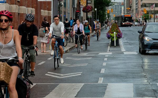
While much has been said about the pedestrianization of Times Square in Manhattan, little attention has been focused on another bold project unfolding on the streets of Manhattan. While the Times Square experiment turns Broadway into a pedestrian-based destination, a recent re-design of 8th and 9th Avenues transforms those streets into bicycle-friendly routes with physically separated lanes for cyclists. The NYC Department of Transportation calls them “fully protected bicycle lanesâ€.
For many years, I’ve heard bicycle advocates fantasize about physically separated lanes. Usually their dreams are referencing examples in Amsterdam, Copenhagen or other far-away cities. It’s easy for our politicians and planners to reject ideas that originate across the Atlantic, but once they start appearing in North America it becomes harder to write them off as something that “wouldn’t work hereâ€. Both Montreal and now New York City have implemented protected bike lanes that give cyclists a safe dedicated space on major arterial streets.
The idea isn’t just to make the streets safer for those who already ride around town, but to create safe spaces on our streets that attract new cyclists. One thing they’ve found in New York is that people are using the 8th and 9th lanes who wouldn’t be riding on the street otherwise, including families with children riding their own small bikes.
So, could we do it here? Yes, but the hard part is finding a street that can accommodate the space required.
“Fully protected†bike lanes take up more space than a typical bike lane, when done properly. The Manhattan lanes for example have enough room for passing, in addition to a buffer zone that keeps parked cars a healthy distance away from moving bicycles. We’ve seen how hard it is to push for regular bike lanes on arterial roads like Bloor. Imagine how hard it would be to advocate for a wide separated lane? The trick is to find streets that have more than 2 lanes running in a given direction. If you have three or four lanes running one way, then you can more easily remove a lane of traffic (as we did on Jarvis). The best north-south location is University Avenue, and the best east-west corridor is Richmond & Adelaide. In fact the Toronto Bike Plan singles out Richmond and Adelaide as an ideal location for a major east-west bike route downtown. The plan says “more downtown commuters will be encouraged to cycle if an east-west bikeway in the Richmond-Adelaide corridor were provided.†The Plan specifically mentions the success of the separated lanes in Montreal and proposes a study for implementation on Richmond and Adelaide.
Here’s where things get complicated. The reason that Richmond and Adelaide could support wide “fully protected†lanes is because they are one-way streets, much like 8th and 9th Ave in New York. With four (sometimes five) lanes running in one direction, there is more than enough space to easily accommodate this kind of bicycle infrastructure into the existing streetscape
A recent proposal from Councillor Adam Vaughan to make Richmond and Adelaide 2-way streets could eliminate the possibility of having separated east-west bike lanes in downtown Toronto. Vaughan’s two-way plan is motivated by a desire to make the neighbourhood more livable and to convert the streets from ‘conduits for moving traffic’ into ‘grand boulevards to host pedestrians’. But traffic doesn’t just consist of cars. Traffic includes bicycles and transit as well. The problem with looking at a situation through a “cars vs. pedestrians†lens, is that cyclists often get left out. If our only goal is to reduce automobile traffic, then two-way lanes on Richmond and Adelaide would be the best approach. But if our goal is to create ‘complete streets’ that provide a safe space for all modes of transportation, then perhaps we need to take a step back and look at various options for these streets including both the two-way model and the one-way model with separated bike lanes.
It’s exciting that Adam Vaughan has launched this process. We need more politicians like Adam who are willing to propose bold steps to transform the downtown into a green and livable community. When we do take those steps however, let’s make sure we’ve looked at all the options and made the best choice for all users of the road.
(this article is cross posted from Mez Dispenser and is also published in the new Dandyhorse magazine, available at a bike store near you)
57 comments
It’s worth noting that Adelaide has been substantially throttled at Bay in the last couple of years by lane reductions imposed by both Bay-Adelaide and Trump. It may not be able to do without both lanes but it shows that some reductions can be worked around…
I have always dreamed of a plan like this. Sure two way traffic is good for slowing down and localizing but separated bike lanes can do the same thing.
Using Richmond and Adelaide as a bike facility of some description has been identified off and on by the City for nearly 20 years, and may in fact be getting a bit more study now, or potential study, just like Bloor.
This corridor is also identified in the Bike Plan, but no specifics were given.
One impediment to change/study was apparently the Front St. Extension – where transit was never really thought of as an option to the project. GO has been boosted, so we should be able to work on having these sorts of options become higher profile, even real, and Mr. Vaughan may have to back off somewhat.
Given the area’s designation as an entertainment district, there’s also a desperate need for more sidewalk space on these two streets (not for walking commuting, but for the large crowds moving around within the district). If they are kept one-way, it should be possible to both put a one-way separated bike lane and widen the sidewalks.
The key issue in terms of people living there (which includes me) is that the traffic needs to be calmer. Two-ways would do that, but there could also be ways to do that while keeping one-way.
There’s also a need for some imaginative use of space – for example, temporarily taking away a lane of traffic on busy entertainment nights to create more space for the crowds.
From the photosimulation provides, it would appear that all on-street car parking has been removed? Great if you want people to zip through the corridor. Bad if you want to make the street more viable for streetfronting businesses, and animate the sidewalk. I think the diagonal striped area in the second photo could be used as on-street parking (as it sometimes is in Europe). What better physical protection for bicycles could you ask for than a wall of cars?
Hey Sean,
If you look closely, you’ll see that the far left car lane is actually parking.
The street layout is pulled from a photo of a new separated bike lane in Manhattan. The approach is (from left to right): sidewalk, bikelane, buffer, parking, car traffic, sidewalk.
I think this is a really interesting idea. I’ve never quite understood why Richmond had to be designed as a mini-expressway. I think on-street parking is a really poor use of space generally and generates a host of infrastructure problems (traffic flow, street cleaning/plowing, etc.). I think strategically placed parking lots (preferably multistory, for efficiency) are a better solution.
I am a bit confused about the one-way street issue. Leave the street one-way for auto traffic, and then install separate, two-way dedicated bicycle lanes.
Sean: form the looks of it, the photo HAS KEPT parking beside the bike lane.
The King-Spadina secondary plan calls for the gradual removal of parking on Richmond and Adelaide. First trees would be installed as bulb-outs, and then wide sidewalks would fill the parking spaces. In my opinion this still leaves laods of room for bike lanes.
But I also think taking these two streets and turning them into 2-way is ideal. But I would suggest reducing them to 3 lanes, with 2 lanes in one direction and 1 lane in the other direction. This leaves room for a dedicated bike lane or just painted lanes.
My preference would be for separated lanes on University and/or Bloor. A raised curb, a la Copenhagen, is all that is needed.
Matt, There are four lanes now. If wider sidewalks take over one lane, and three lanes are maintained for cars, that won’t leave enough room for a separated bikelane with a buffer. The most you’ll get out of that configuration is a painted bikelane, like college. We’d lose the only chance we have for a separated east/west bikelane.
University is good option for north/south (because it is essentially two one-way streets – ‘parallel streets’). As for east-west, Bloor doesn’t even come close to having enough space, unless you made it a one-way street.
Look at the photo above, folks. A properly built separated lane is much wider than a regular lane. It’s at least 1.5 times the size of a regular shared lanes. Three times the size of a regular bikelane. They need extra room for passing, and they need a good buffer zone to keep doors away. They need a lot of space. I am convinced that they would not fit on a 2-way Richmond or Adelaide. If Adam Vaughan, or anyone else, can show us a detailed plan that includes a separate bikelane, I’ll get behind it 100%.
From the rendering above, it looks like you could have one lane of traffic each way, plus parking, plus a separated bike lane. Put another separated bike lane going the other way on Adelaide, and voila: you have two-way traffic, parking and separated bike lanes going east and west!
Dave/Matt: I wasn’t sure if that was parking or just striping.
“Three times the size of a regular bikelane.” – that’s 4.5 meters, incredibly wide. One-way separated bike lanes aren’t nearly that wide in Copenhagen or Montreal or Paris (which are the ones I’ve seen). Maybe New York, but only University Ave. in Toronto is comparable to a New York boulevard in one-direction width.
For one thing, you could remove parking so you don’t need a door zone.
This is a great debate. It is time to return Richmond-Adelaide to the people who live, work, run businesses and walk, cycle and transit through the community.
For the record the only portion being studied for re-design is the span between University and Bathurst.
I have proposed the two-way idea because of the new uses and movement patterns emerging in the neighbourhood. It comes after three years of discussion with local community members and the new BIA.
No final decision or design has been proposed. Whatever direction we move will seek a balance of residents and non-residents. Transit and private vehicle movement in the are (which includes looking at ways to take pressure off the King and Queen Streetcars), cycling needs must be addressed, pedestrians must be accomodated.
How we share the street, transform the street and ultimately return the street to the neighbourhood are huge challenges.
A new secondary plan for the area is about to be tabled at City Hall. a master plan proposal for the area by the local BIA has just been released, and a transportation study looking at how people in the neighbourhood and people moving through the community will all have opportunities for new ideas to be tested and hopefully incorporated into new streetscapes that hopefully make us all happy.
Will it be two-way? will bike lanes be dedicated or standard size and style? How much street parking is needed, How wide should the side-walks be? Can we get trees planted? ….
Stayed tuned hopefully it’ll be a great ride.
Adam Vaughan
City Councillor
A very interesting topic. As Mark noted, the closing of two lanes of Adelaide at Bay has demonstrated that the city has some flexiblity to consider lane reductions on these streets. As a pedestrian that jaywalks across Adelaide every day, I find it a bit easier that it is a one-way street; however, it would be nicer if it were narrowed.
While I don’t want to sidetrack the discussion, one other alternative configuration that might be worth evaluating would be a dedicated streetcar lane on each of Wellington (westbound) and Adelaide (eastbound) in lieu of the King Streetcar through the downtown core.
These dedicated lines should be much more predictable and faster than the existing King streetcar line. Despite the recent momentum regarding the Downtown Relief Line, aligning the DRL with King downtown appears to be prohibitively expensive given the extensive underground structures (PATH, etc.) along King.
This plan still leaves space for a bikeway on Richmond. As well, cars would be able to move down King at a more predictable rate if the Streetcars were removed from King and instead used dedicated lanes on Wellington/Adelaide.
Image is nice but…
Bike lanes. Check.
Travel lane. Check.
Parking. check.
Widened sidewalks with trees and other pedestrian oriented stuff? Oops. Forgot about those who travel on foot.
Not sure we need a 3m door zone buffer. Half that would suffice and put to better use to widen the sidewalk. The sidewalks are mean in the entertainment district where, correct me if I’m wrong, most people walk.
Like Jarvis, improvements to the ped environment comes at the cost of providing bike infrastructure while maintaining space and facilities for cars. Yeah, they might function better for 2 and 4 four wheel travel, but do little to entice more to walk: shade in summer? Not without trees. How about beauty? Not unless you think bike lanes are beautiful.
Considering the death of a fellow cyclist today this is ‘timely’ to say the least.
Why is it that cyclists are continually punished? Cyclists don’t pollute, don’t give off heat, and don’t take up as much space as cars yet were still kepts on the sidelines – literally (only occasionally are we protected by bike lanes – when not misused by car drivers as parking spaces).
I hope Mr. Vaughan and other city councillors push to see many renderings such as the one depicted here come to life in our neighborhoods. The people and streets of Toronto need them!
What a great vision to debate around! One of the best pieces I’ve seen in Spacing. Would love to see more of these re-envisionings of key streets in the suburbs too.
I would like to see reworking on Adelaide include the removal of some/all King taxi ranks to there and Wellington. The King westbound rank at Bay frequently overflows into the pedestrian crossing strip at the intersection, and the narrowing the rank creates impedes the flow of the 502/3/4.
The real question with ideas like this is that cities need to get away from worshipping the automobile. Once you realise that the Automobile was an early 20th century ideology for personal transportation, the tail end of that century has provided proof that this ideology was an abject failure.
What is missing from the diagram, is that Adelaide has streetcar tracks, so we need an extra lane in there for the streetcar. Street cars and bicycles do not mix well, although a streetcar lane could be placed beside the bike lane, providing the tracks are kept at between 45 and 135 degrees to the bicycle lane. I think any time you rebuild a road with streetcar tracks, the streetcar should get it’s own lane, especially in the core.
Not to rain on councillor Vaughan’s parade, but these streets are one way for their entire length, so making one short section 2 way, would confuse the heck out of drivers, who are busy yapping, texting and surfing on their cell phones, probably more so in the downtown core, where many people treat their cars as rolling offices.
Business Improvement Associations (I really think that BIA should stand for Business In Automobiles), always want huge amounts of tax payer funded free parking, or at least cheap meter parking. We really need to determine what the priorities should be. You have to wonder though, how much business, for businesses in the core is even automobile based? Of the traffic in the area how much is people who live and/or work in the area, and how much is pass through traffic where they wouldn’t dream of stopping there, but are just passing through on their way to Wally World in the suburbs, because that 50 roll pack of toilet paper is 50 cents cheaper.
I think the order should be, pedestrians, human powered vehicles, transit, motorized traffic, then parking. If the BIA really wants cheap or free parking, then they should find ways of providing it. Many businesses outside the core, have their own off street parking areas, take Yorkdale for example, the parking lot is bigger then the building, and it’s usually full. So why should the onus be street parking in the core. We all know the answer to this, parking, especially in a land restrictive area like the downtown core, is horribly expensive.
So make for nice wide sidewalks, put in a bicycle lane (same direction as other traffic) add a streetcar lane, then see how much space is left, if there is enough, add a traffic lane, parking should only be provided if there is space left. Thinking about this, maybe the right hand lane should be the streetcar lane, with the bicycle lane to the left of it, would mean that people waiting for a street car do not need to cross the bicycle lane to get to it.
All you need for a bicycle lane buffer is a row of trees or bushes, a hedge if you will, would help absorb some of the motor vehicle exhaust. This is something else missing from the diagram.
NO NO NO! People are just going to walk or stand or ride the wrong way on it and since we’ll be banned from using the grownups’ car section, there won’t be room to get around! This I promise!
I was actually almost got killed on the protected bike lane on 8th ave in NYC. A truck made an illegal left turn. When the driver eventually slow down and stopped on the bike path at the intersection, I was so close to hit the truck. I slided and fall onto the pavement. I was riding fast and the driver did not see me because the protected island created a wider blind spot. He did apologized.
What I want to say is the bike separation lane is definately a very good idea, but the education to all shared user of the right-of-way is more important regarding any type of traffic control to be implemented. Bikes should be a mojar part of the future transportation (motorized or man powered), the bike lane should be the way to go. Only concern is the usage during long cold winter in Toronto.
I agree with Chantale but also with baray. The “improved” version is still brutally without trees and anything making it pleasant for pedestrians. That area is very walkable indeed, and walking should be encouraged as much as cycling. If we include mobility devices such as canes, walking frames and wheelchairs, pretty much everyone can walk, all year round.
My condoleances to the friends and family of the cyclist who was killed by that so-called pillar of society.
I know what I’m about to say is unrelated to the story but I always thought that given the traffic clutter on King and Queen, wouldn’t it be possible to run a streetcar ROW on Richmond/Adelaide, especially what with all the talk of a downtown relief line?
Contra-flow bike lanes on these streets. That means the segregated bike lanes on Richmond will go eastbound, and Adelaide westbound.
Terrfic photoshop of what looks to be a part of 8th Ave or 9th Ave in Manhattan. Nothing communicates better than a photograph.
Amazing that Toronto now has to crib from big, bad New York instead of the other way ’round (http://bit.ly/3XWT4) but there is much to learn. I can report that the change in Manhattan has been nothing short of astonishing on these protected-lane streets. Crossing them is easier and even walking along them is far more pleasant despite no changes to the sidewalk. There truly is something going on in Manhattan, something that will be taught in many a future urban planning course — people are using and living in and occupying space in the streets again; the rules of the game have, in the blink of an eye, changed completely.
Just today I walked across Broadway at 58th St, a small, unheralded section that due to the changes farther south at Times Square was suddenly wider than it needed to be. Five lanes of Broadway in the upper 50s are now two, plus parking and a protected bike lane. The buffer in this case between the lane and traffic is about 10′ wide, painted with a colored, textured paint and filled with aluminum patio furniture. As I was crossing Broadway I looked south and saw dozens of people sitting in the chairs, under umbrellas, reading and chatting. I turned and looked north and saw over a hundred people sitting in the lush middle of what used to be a bare traffic circle (http://bit.ly/12uaia), hanging out, munching on Whole Foods snacks, showing their children the fountain. All of these people were nonexistent just a short time ago but now they were sitting in the middle of the street, soaking up the sun and creating every possible urban benefit ever noted by Jane Jacobs. No “pilot project” status is going to hide the fact that things are never going back to the way they were. The streets are back in play for all uses, not just transportation, and people are loving it. Glad to see the word getting out. Go for it.
@Jordan, Richmond and Adelaide are only used by diverting streetcars, not streetcars in service. On the other hand, the 14* series of buses do service them, including the forthcoming 145 Downtown/Humber Bay Express. The change of most 14* routes to standard rather than double fare (pushed back to 2010) will hopefully increase the use of these routes and thus the importance of R & A as transit streets.
Tiffany: “it looks like you could have one lane of traffic each way…”. One lane traveling in a single direction is pretty rare downtown. The reason is that planners are hesitant to have a lane of traffic that comes to a standstill when a vehicle stops to pull over for a minute – like a taxi, or a delivery truck. So, I doubt that would be a viable plan.
Sean: The striping is just striping. That’s the buffer. The parked cars are to the right of the buffer.
Dylan: I know that 4.5 metres sounds like a lot, and perhaps they can be smaller. I Was just estimating. The point is: if we want room for passing, and we want the buffer zone, these things get quite wide. You can see this is the photo above (which is an actual street, in Manhattan).
Adam: “It comes after three years of discussion with local community members and the new BIA.” I think that might be the problem. As an arterial street, I think the discussion should have been broader. These streets are part of a neighbourhood hood, but they also serve as veins in two important networks: The TTC, and the Bike Plan. The Bike Plan was adopted in 2001, affects thousands of cyclists, and shouldn’t be over-ruled by a local community without a broad open discussion.
Baray: I’m all into widening sidewalks, but not at the expense of providing basic infrastructure to other modes of transportation. Personally, I think Toronto’s “Transportation Hierarchy” should be replaced by a “Complete Streets” model that first aims to give safe space to everyone, and then, if there’s space left over, decides what to do with that space based on community needs. Trees are nice too, but again, not at the expense of safe street infrastructure. I’d rather have a bikelane than a tree. you also wrote: “How about beauty? Not unless you think bike lanes are beautiful.” Um, yes. I do think a bikelane is beautiful. Especially when it’s full of cyclists.
Kam: Thanks! : )
Spiny – Why do you think pedestrians will invade the space? This hasn’t been the experience in NYC or any of the European cities I’ve been to, nor on any of Toronto’s existing bikelanes! (cars in the way.. yes. pedestrians? not so much).
Chris: “Only concern is the usage during long cold winter in Toronto.” Check this out: http://meslin.wordpress.com/2009/08/25/demilo-2/
I’d actually prefer leaving Richmond and Adelaide as the one-way auto-centric arterials that they are, and instead play with Queen and King more, including transit/pedestrian malls. Though I’d like to see a deMaisonneuve style bikeway across either.
Richmond and Adelaide are built for the auto in the 1950s and 1960s with the DVP off ramps and somewhat synchronized lights. They function relatively well as such, and have no transit apart from the 140-series premium express routes. Leave them as one-way streets and focus where the action is, though some sidewalk widening (especially around 401 Richmond) and the bikeway are great ideas that should be implemented.
Come to think of it, why are we talking about a buffer at all? If there are bike lanes on a one-way street, you just put them on the opposite side of the street from the parking. No need for a buffer. If you want separation, you just put something narrow but solid in between the bikes and the cars. That’s the way it’s done in Montreal and Paris.
I live on Adelaide and I don’t entirely appreciate how noisy it is (it seems to be the favourite street of wailing fire trucks). I’m also fairly clumsy, and a cyclist, so when I am killed by a car I would prefer if it was later in my life. I think protected bike lanes would probably extend my life span.
Why would it be safer to put a gigantic buffer between bikes and cars?
If anything, this causes visibility issues. Unless all left turns are protected and given their own phases, in the photoshop shown cars would be making left turns across a lane of live traffic (bicycles) separated by a gigantic blind spot. Forcing cars to make turns across through bike traffic seems to be a common element of poorly thought out bike lane designs (automobile right turns on College St…).
Sure, phyiscally seperate bikes and cars. But no moreso than the Spadina streetcars are separated from auto traffic. Enough to create a clear barrier, but not enough to create a safety issue where one wasn’t before.
We need to turn at one lane on both adelaide and richmond into one directional safe east west cross town bike lanes. It would be so easy, and i doubt traffic would even change that much. So many people get hit by cars it is really discouraging and scary and it’s just not right anymore to pretend that we are doing something about carbon, about smog, about making a walkable, bikeable enjoyable city when we are hardly even trying at all.
It would make it quick, safe and healthy to get across town. It would take people out of their cars, and out of our over crowded rush hour street cars. It would really revitalize the city and it will save money.
Does anyone if the city has ever hired traffic consultants to estimate the impact of this?
Hi everyone. I really can’t see why what I’m about to suggest is far-fetched. Please correct me if I’m wrong (and sorry in advance for the long post).
I think this is a really big opportunity for Toronto to shift transit gears and I think Sean Marshall’s statement above is on to something. Keep Richmond and Adelaide car-centric (while improving the sidewalk-pedestrian conditions–it’s pretty damn drab down there!) and start turning QUEEN STREET (and King, for that matter) into a more efficient LRT/cycling/pedestrian-friendly corridor. This makes so much sense for Queen Street, which links (just about, anyway) so many great public places within bikeable distance (High Park-TBPark-Nathan Phillips-Leslie Spit-Ashbridges Bay) and does NOT require direct, general-public street-parking in order to thrive commercially (and if parking is such a crucial concern, how about a few strategically placed parking structures since we’re making NYC comparisons? Or, better, take your chances parking on side streets like every other out-of-area traveler who still manages to shop/eat/drink on Queen). Queen is already very high-profile (for locals and tourists alike) and is in a prime position (geographically, culturally, commercially) to be a corridor that BENEFITS from better light rail service, more secure cycling and a tiny bit more room for pedestrian traffic. This, of course, requires restricting car parking and probably discouraging general car use, at least during peak times.
Driving/parking sucks terribly on Queen during peak hours as it is. Why does the whole street need to suffer because of the illusory “necessity” of street-parking (at least from Yonge to Roncesvalles). If we could accomplish this on Queen and King were to improve its transit service somewhat, perhaps a DRL subway, pipe-dream though it apparently is, may not be necessary.
In short, isn’t an optimised, “complete” Queen Street ultimately worth more to the city (in terms of day-to-day transit flow, aesthetic profile and OVERALL IMPROVED CONNECTIVITY) than adding bike-lanes to Adelaide and/or Richmond?
Just wanted to test those waters…
Still absorbing all the comments. A great exchange of perspectives and ideas.
A couple of points to consider.
– While Richmond and Adelaide appear to run in paralle,l Richmond of course zigs and zags near Spadina. Between Peter and Spadina a new sidewalk on the south side will soon replace the concrete barriers that ring 401 Richmond. The new streetscape will narrow the road and provide new trees and benches and bike rings. It will also eliminate the lay by near the Spadina corner to create a more generous pedestrian area outside 401 Richmond.
– Adelaide used to have full (two-way!) streetcar service the tracks are still there between Bathurst and University. Adelaide like Richmond is not a consistent width between University and Bathurst.
– Don’t be so hard on the BIA. They support a proposal in the area to turn John Street into a avenue that could be closed off entirely (or in segments) for festivals, summertime car-free zones either block by block or all the way from Front to Queen. They are very supportive of changing how these streets are used and are eager to help finace some of the improvements including trees, benches, the construction of new public squares and all that. They are also strongly advocating a heritage preservation strategy in the area to protect the old warehouses. Give them a chance before they are judged too harshly.
– Both streets stop at Bathurst (although Richmond used to continue west to Niagara before it was reversed twenty years ago). The reason these two streets can be redesigned between Bathurst and University is because both Bathurst and University are unusually wide and can accommodate the any switch over of traffic. Anything east of University finds most north-south streets too narrow to work out complications. Spadina is confused by the dedicated street car lanes.
– The reason talk about changing how the streets work and serve the people who use them started with local residents and local businesses is hopefully self-explanatory. As the local councillor I hold regular meetings with these two groups to talk about planning issues and development pressures present in the community. As we all tried to accommodate and shape growth in the area, the way the streets were working constantly came up as areas of concern, The TTC did not want new buildings to have entrances on Queen and Spadina, the TTC was also talking about eliminating lanes of traffic on these two streets. Construction projects pinched and at times shut down smaller streets in the area. The Front Street extension at first loomed then was killed. Cyclists in the neighbourhood complained about no north-south or east-west bike lanes (Spadina doesnt count). It became clear to all that a new vision for the area’s streets was needed. The one we had was outdated.
– Richmond and Adelaide were turned into one-way streets as part of a cold war exercise. In order to evacuate the city after the Russians dropped the bomb speedy access to the city’s highway system was declared a priority. Access to the Spadina Expressway and the Gardiner off-ramp at Bathurst was deemed necessary. Bathurst was widened below Queen, Richmond and Adelaide converted to one way arterial roads. Front Yards were expropriated, sidewalks removed and of course public transit eliminated. In the end the only bombed dropped was the planning bomb that literally bulldozed a street in the name of efficiency. A to B arguments have their limits. The irony is of course the Spadina expressway (another efficiency exercise that claimed getting there was more important than being there) and the on ramp to the Gardiner at the foot of Bathurst were never built. Local citizens stood up, fought, and won the right to protect Fort York and then all Downtown communities. An era of Robert Moses like planning, with centralized top-down decision making processes, was replaced by community led programmes that sought to re-establish the neighbourhood as the central building block in city building exercises. That fight continues now.
– At Sept community council meeting a proposal to re-examine the street system in the King Spadina Secondary Plan area will be debated. The TTC as well is conducting a study in the area. The process will measure and explore all of the ideas captured in these posts.
In the end the only fixed points in this debate are the building faces along Richmond and Adelaide. In my mind everything in between is up for re-examination. Will all the ideas find space, obviously not, hopefull (especially bike lanes) will. One thing I will promise. The lane widths for cars will be reduced from the current highway standard of 4.1m+ to a downtown norm of closer to 3.1m. This alone will create space for other uses to emerge and balance how the streets perform…trees, bike lanes, wider sidewalks, who knows. Keep the ideas flowing… in all directions!
Adam Vaughan
Unless they are properly separated from car traffic I think bike lanes are really not very useful and can give a false sense of security. I accept that sometimes it is not possible but I think that these should be the ‘gold standard’.
On Richmond and Adelaide it would seem possible to install properly separated bike lanes and maybe then put the on-way streetcar tracks right beside them so that all parking would be on the other side of the street. (The ‘zones’ would thus be: Sidewalk, cyclists, streetcar, traffic, parking, sidewalk). The streetcar tracks on both streets are scheduled for replacement between 2010 and 2012 so this is clearly the time to thik about doing this, or something better.
I don’t ride a bike and rarely drive my car about once a week in the city. Walking and transit are what I do and don’t believe bike lanes and cars should take all the available space. If serious about transforming these neighbourhoods, a more beautiful and balance public realm is needed: healthy and large trees, broader pedestrian spaces, bikes AND cars.
Not sure if transit could work unless TTC change their minds about mixed-traffic operation. Might be possible to follow more of the Portland model where one-ways work with all modes well-served.
Here is an excellent video advocating physically separated bicycle lanes in NYC. It makes sense and I personally think it is the future of transportation:
http://www.youtube.com/watch?v=ONS2ptAR4mo
The streetcar tracks on Adelaide between Bathurst and Spadina were taken out of service in 1966 when the Bloor-Danforth Subway opened as the Bathurst-Downtown tripper service was discontinued. The tracks were paved over/torn up in the following years. The tracks are still in place from Spadina, although completely unusable east of Charlotte St. through to Victoria St, and then a short section of usable track between Victoria and Church St.
Adelaide was used annually as the diversion for the Queen streetcar during the Santa Claus parade throughout the 1960s and 1970s between Spadina and Church.
The pinch on Adelaide at Bay, where it narrowed to two lanes routinely caused traffic backups to University Ave. every midday-afternoon and rush hour, plus one or both curb lanes are almost always blocked by delivery/courier trucks, cabs, or cars stopping to pick up/drop someone off. Unless you give the trucks and cabs some place to wait, narrowing the street will just narrow it further as the trucks and cabs will STILL block the curb lanes. The fact is there are almost 5,000 cabs in Toronto (thanks to the Licensing Committee adding more and more), which may be way too many chasing too few fares, so that’s why there are always long queues of them sitting everywhere. Either give them dedicated stands, or cut the number of cabs.
I was sorry to read in Adam Vaughn’s pieces (good to see a Councillor participating!) that the City is not studying both Adelaide and Richmond east of University. I realise the two parts of the streets are not exactly the same but I wonder if the reason is more that Adam’s Ward stops at University and the eastern section is in Pam McConnell’s Ward.
In my opinion, the City needs to look at both streets from Bathurst to the Don Valley, not necessarily with the aim of making both the same for their whole length but it seems silly to me to look at a section of a street and, as Adam notes, both streets feed into/out of the Don Valley Expressway and they DO serve a useful purpose. The challenge will be to provide adequate routes to and from the DV and create two bike and pedestrian friendly streets going as far east and west as feasible. (After study this MAY be Bathurst to University or could be Bathurst to Jarvis or ???) Let’s not restrict the debate by restructing the area being studied.
I’d like to thank Adam Vaughan for taking part in this on-line discussion. I wish all councilors would do the same about issues in their wards. The information about reducing lane sizes from 4.1 to 3.1 meters was very important, as it gives us essentially another lane that can be used for wider sidewalks.
I am a big fan of what Waterfront Toronto is doing for the city of TO and mostly try to support BIAs – especially when they are trying to beautify the surrounding areas with trees, public spaces, etc. I was really disappointed though when the Bloor BIA Project Manager emailed me back a few months ago telling me that they hadn’t planned on incorporating bike lanes in this grand project of theirs. I think it’s great to have these grand boulevards for pedestrians (even though some store owners were to cheap to replace their old concrete sidewalks so that now you still have an ugly patchwork of new and old)but why couldn’t they try to accomodate space for everyone? Why are cyclists never considered in TO? We pay the same tax dollars as everyone else don’t we?
Skube: Watched the video on cycling. Great stuff!!! I totally support the idea of having protected bike lanes next to the sidewalks instead of the middle of the road. I’m sure it saves a plethora of frustration/injuries and lives!
Councillor – I hope you can table all of these great ideas for us at your next committee meeting!
“Unless you give the trucks and cabs some place to wait, narrowing the street will just narrow it further as the trucks and cabs will STILL block the curb lanes.”
Unless you have proper enforcement. I do see bike cops ticketing occasionally on the Bay street bus lane between Richmond and Adelaide (and because they don’t direct them onto Temperance end up blocking said lane, but anyway…) but until TPS and the City work out a protocol that in rush hour traffic violations in downtown from Bathurst to Jarvis and from Queens Quay to Bloor will be punished without fail, there isn’t going to be a disincentive for people to impede other road users – transit, cyclists, pedestrians and other motorists.
I’m with Sean Marshall – we need Queen and King to be transit priority corridors, and that includes restricting the right of MuchMusic to close the damned street every time some tween heartthrob is in town.
Dedicated bike lanes could work, but only if cyclists were banned from parallel roads like King and Queen where they only serve to wreak havoc.
Anything that keeps irresponsible cyclists away from motorists and pedestrians is a good thing.
Dylan – Good point. I think that would work, which gives more room to expand the sidewalk. It doesn’t change the main thesis though – that separated lanes only fit by maintaining a one-way design.
Ian – You raise a good point about safety and visibility at intersections. My friend Kevin asked me the same question yesterday. Here’s my response:
“The NYC Department of Transportation did extensive research into how to make separated lanes safer. They made a whole bunch of alternations to the usual style of separated lanes, to reduce collisions at intersections. A rep from NYC DOT did a presentation on exactly this topic, at the Bike Summit earlier this spring. I’ll try to find the PowerPoint from the presentation, but I think the main components were:
1) losing the parking and the buffer, as the lane approaches an intersection, so the moving cars and bikes are side by side.
2) extending the bike lane markings through the intersection, so drivers can see that they are driving into it.
3) separate signals for the bike lane.
4) increased signage.
As far as they were concerned, this would make the lanes as safe, if not safer than, regular lanes”.
Krista – “Does anyone know if the city has ever hired traffic consultants to estimate the impact of this?” I don’t believe the city has studied it. They were supposed to. Staff recommended a study, back in 2001, to specifically look at separated lanes on Richmond and Adelaide. This step should be taken, as part of any plan to re-design the street.
Lucas – I don’t believe a ‘complete street’ is possible on Queen without a huge shift in the political climate at city hall, and in the BIA community. Also, keep in mind that the streetcar tracks minimise our ability to play with lane widths (See Adam’s comments about reducing width). For the record, if Adam V wants to turn Queen into a Green Transportation corridor, then I’m all for leaving Richmond/Adelaide as they are. But until we have plans for that, let’s not lose the chance we have on Richmond and Adelaide by making them two-way. We shouldn’t close that door, unless another one has opened fully.
Adam V – I have no problem with the fact that you wanted to ‘start’ the conversation with the local residents and businesses owners. That’s your job as a city councillor, and you do it well. And I agree that “a new vision for the area’s streets was needed.” But that discussion could have sparked a few options, which then could have been discussed by a larger group. At that point, cyclists would have contributed to the discussion, the Bike Plan proposal would have been raised and it would have been a more participatory process for users of the road. Instead, a single proposal to convert the street to a 2-way design was put forward, which possibly contradicts the city’s previous plan. So now, let’s all work together to find a way to incorporate all of these goals, and build a street that works for everyone, while providing a much-needed east-west bike corridor. thanks for engaging in this discussion with pesky people like me. I don’t live in your ward, but I’m in it every day. You are the steward of our city’s heart. : )
David – I agree! Let’s look at these streets, from Bathurst to Parliament. Imagine a bike-way that ran from end to end. This would reduce injuries and would encourage hundreds, maybe thousands, to try riding their bikes downtown.
I would want to be careful about lane widths and how much space can be reallocated. Scaling off Google Earth, it looks like there are some significant sections where the curbs are in the area of 13 metres apart (or slightly less), which works out to 3.25-metre lanes. Other sections (particularly in the east) appear to be closer to 3.75, on average, which does allow a little more room to play around, but it doesn’t appear to be continuous through the corridor. I don’t see anything as high as 4.1, certainly not where the average is 4.1 (a 16.4-metre wide road?).
I share the concerns over visibility at intersections so I was interested in reading Dave’s comments from New York.
Specifically, about the separate bike signals — how do they work? Is it like on Spadina where bikes have a green while through traffic has a green, and turns are held… or do bikes have a separate green apart from through traffic (like on Queens Quay)? The former has more traffic flow implications, but the latter would have major implications on cyclist delays. Both could potentially mean having to lengthen the cycle time, which means potentially higher delays for everybody.
It’s interesting to note that on some streets like Spadina and St. Clair even the streetcars are physically separated from traffic.
If a streetcar is to an automobile as an automobile is to a bicycle, surely bicycles warrant physical separation too.
Former NYC Traffic Commissioner Schwartz (@2:00) believes the in the restoration of physically separated bicycle lanes:
http://www.youtube.com/watch?v=ONS2ptAR4mo
(Sorry for the repost, but it really is a great video)
Dave, as promised this is the start…. and a great start thanks.
Adam V
PS pesky?… nah more perky!
Kudos to councillor Vaughan for actually being here for the discussion. The events of the last few days, show that the city needs to make a decision on what it wants to be. The bicycle can be the cities best friend, it’s small, compact, makes virtually no noise, and does not pollute the air or water. In the next 100 years, we will find that oil will become to valuable to burn, and that the automobile, is too much of an energy consumer for a post oil world, gridlock will turn a 30 minute commute in 1969, into a 90 minute commute now, into a 270 minute commute, probably within the next 40 years. Then there begs the question, where do you store those cars?
The problem with the bicycle, now we need infrastructure, until we reach the tipping point when bicycles and transit become the predominant way of getting around. City hall needs to make a decision that when streets are repaved or rebuilt as they normally are on occasion, that bicycle lanes are part of the street specifications, just like sidewalks are now. Rather then treating them the same as zoning variances, which require approval.
Woohoo! 50 comments. Looks like we have a nice dialogue taking shape.
Thanks for the comment Adam! Looking forward to more discussion. (let’s grab a drink sometime. this ‘comment’ stuff is kinda impersonal. we can bring sketch pads and draw street layouts…)
Wogster wrote: “City hall needs to make a decision that when streets are repaved or rebuilt as they normally are on occasion, that bicycle lanes are part of the street specifications, just like sidewalks are now.”
That’s exactly what I’m proposing with the “Complete Streets” policy. Our current policy aims to widen sidewalks first, plant lots of trees, focus on the ‘public realm’*, and then see if there’s any room left over for bike lanes – and there rarely is (Lansdowne, Bloor, Roncy, St. Clair, the original Jarvis plan, etc, etc, etc….) This is because progressive planners currently equate ‘width reduction’ with ‘automobile reduction’, when in fact width reduction pushes out cyclists too.
‘Complete Streets’ policies look at the big picture, strive for the minimum space required for each mode to get around safely, and then allocate any leftover.
* i put ‘public realm’ in quotes, because I think the term is being misused these days. in the jarvis debate, for example, people framed the debate as bike-lanes VS the ‘public realm’. Um… bike lanes are part of the public realm. Just ’cause they exist between the curbs, doesn’t mean it’s not public space, or a good use of public space. Very frustrating….
The rendering looks terrific, and I like this better than the two-way idea too. I believe it serves the purpose of calming the traffic, and this is more friendly to pedestrians and easier to cross (yes I mean jay walking), not to mention the benefit to cyclists. Just one thing, if I were to design it, I’d put the parking lane to the far right, next to sidewalk rather than to the bike lane. The benefit, you would not need as wide a door zone as the design shows, the space saved can be used to widen the sidewalk. The parking lane will also serve as a buffer between pedestrians and moving cars. Where the streets are narrower, I’d suggest that we can remove the parking lane. 13 meter should be plenty for 2 car lanes, 1 dedicated bike lane with some buffer, and wider sidewalk.
A streetcar is not to an automobile as an automobile is to a bicycle.
The purpose of the streetcar lanes is primarily to get private vehicles out of the way of streetcars to allow for faster and more efficient streetcar service.
The purpose of bicycle lanes is primarily to give bicycles a protected space where they have better separation from cars and therefore increased safety (I know some would argue the level of protection or safety). Separating bikes from auto congestion is a side benefit but not the main intent.
If you are advocating for physically separated bike lanes, a better analogy would be to say that a pedestrian is to an automobile as a cyclist is to an automobile (i.e. pedestrians have separate infrastructure separating them from automobile traffic).
Dave:
Interesting comment on the “public realm”. I agree it isn’t the best term — perhaps “pedestrian realm” would be more accurate.
To clarify, would you then consider bike lanes to be part of the “public realm” while excluding automobile lanes and transit lanes? or would all space for modes of transportation (e.g. transit, bicycle, pedestrian and automobile) be included?
You are correct Brent, my analogy wasn’t technically correct. But I think the main issue of having a physical is still valid. We have a physical separation between streetcars and automobiles, and also between automobiles and pedestrians. And even between cyclists and pedestrians. So why not between automobiles and cyclists?
This is fantastic, and I’m glad to see Adam Vaughan participating!
Looking at the rendering above, I think there is far too much space given to the ‘buffer zone.’ This space could be used for sidewalks and trees. Maybe just have the bollards and then angle-parking to eliminate the possibility of a door-prize. (are we allowed angle-parking?) Or maybe islands, curb-height and about 3×5. Having the bike lane raised a few inches, and then the sidewalk raised a few inches more, would help the flow.
I think the bike lanes would be used in both directions, and should thus be two-way. If it becomes jammed, build more! It makes sense for a bike lane to have points of departure and not leave you in a lurch: there must be options, be it another bike lane, a quiet side street. Between University and Bathurst there are many of these points of departure.
Love the idea! Richmond can become a two way street, with regular traffic heading westbound, and the fully separated bike lanes headed eastbound (same with Adelaide).