
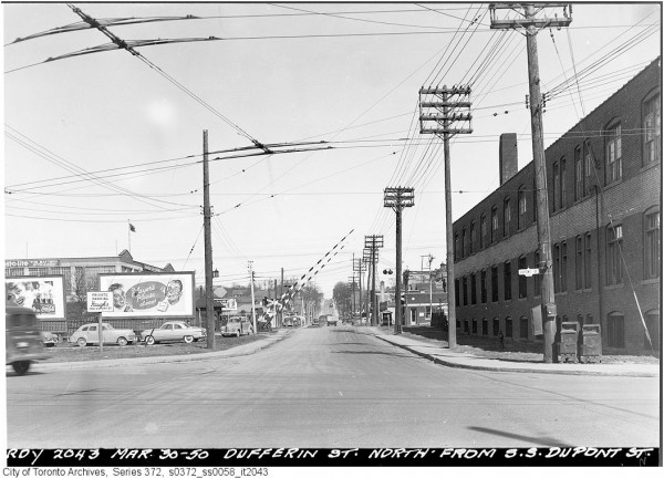
Dufferin Street, looking north at Dupont, 1950. Note the wires for the new Annette Trolley Coach route on Dupont and the level crossing with the busy Canadian Pacific Railway. Credit: Toronto Archives
Dufferin Street may not have the cultural history and vibrancy of Queen Street, or the legendary status of Yonge Street, whose claim to fame as “the world’s longest street” is a quaint urban legend of sorts, but Dufferin still has a rather interesting history. South of Eglinton, Dufferin Street made a transition from a minor residential street to a busy arterial. A once-notorious racetrack is now a busy shopping mall, and other transportation systems created jogs in the road, one recently fixed, another to remain as long as Downsview Airport is required. Today, the 29 Dufferin is one of the busiest bus routes in the TTC’s system, but it is a relative latecomer; before 1960, there was no scheduled transit service south of Eglinton.
Dufferin Street started out simply as the second line west of Yonge Street, York Township (Bathurst being the first line west of Yonge), and known simply as the Side Line. It was formally named in 1876, for the then Governor-General of Canada, Frederick Hamilton Temple Blackwood, known as Lord Dufferin.
A career British diplomat, Lord Dufferin served as the third Governor-General of Canada from 1872 to 1878. Dufferin embraced that role, setting a high standard for future Governors-General. Fluently bilingual, Dufferin established academic awards and the first governor-general’s trophy for sport (for lacrosse; future G-Gs Lord Stanley and Earl Grey would found more famous trophies), championed the preservation of Old Quebec, and visited all of Canada’s then-seven provinces during his six year term.
By the time Dufferin Street (and other grid roads) was surveyed, a few other streets in the area were already established. Lot Street (soon renamed Queen Street) developed as the Base Line for all major east-west roads to the north. Dundas Street, one of the first military roads to lead out of the city, branched off of Lot where the present-day Queen and Ossington intersection is today, meandering west towards Dundas and London. In 1856, the Grand Trunk Railway’s Toronto-Sarnia-Chicago mainline cut right across the intersection of Queen and Dufferin. The GTR was later jointed by the Toronto, Grey and Bruce and Credit Valley Railways creating a wide corridor not easily or safely crossed at grade. With the construction of an underpass (they were then known as “subways”) on Queen Street, Dufferin Street was severed and for over 100 years, traffic was forced to detour via Queen, Gladstone, and Peel Streets.

Dufferin Street looking north to Queen Street, 1898. Credit: Toronto Archives
In the 1860s, the Toronto Street Railway was incorporated. After the initial Yonge Street route opened in September 1861, a second route, on Queen, opened that December. The original Queen car ran west from St. Lawrence Market to the Asylum at the intersection of Dundas. The Brockton car line was established in 1882. That route ran from downtown, west on Queen Street and then northwest on Dundas (Ossington) to the edge of the then-incorporated village at the corner of Dundas and Dufferin Streets.
By the 1920s, streetcar tracks in the west end ran north-south on Bathurst, Dovercourt/Ossington, Roncesvalles, and a short section of Lansdowne, though east-west car lines such as Bloor, Queen, and King were the dominant routes. Tracks were laid on Dufferin Street from Queen Street south to the Exhibition Grounds, but this trackage was only used for detours and special services to the West Gate of the CNE. To this day, those tracks remain for short turns and detours on the Queen and King carlines. The only other streetcar tracks on Dufferin was a 50-metre long jog connecting Hallam and Lappin, which were part of an extension of the Harbord Streetcar, opened in 1916. The Harbord Car was re-routed in 1947 as part of a restructuring of several west-end services, and the tracks on Hallam, Dufferin, and Lappin were removed. Retail strips were established along the east-west streetcar routes while Dufferin Street itself remained primarily residential.

Dufferin looking north to Shanly Street, 1949. Credit: Toronto Archives
Through the 1950s, Dufferin Street in the former City of Toronto was a narrow two lane street, mostly lined with houses with small front yards; this was consistent with its status as a secondary road. The only major landmark at that time was Dufferin Park, a horse racing track that was one of many scattered around Toronto. Dufferin Park started as a private horse track in the 1880s but began hosting public horse racing in 1907 and was nicknamed “Little Saratoga”. The track also hosted local amateur athletic competitions and travelling circuses. David Wencer wrote a great history of Dufferin Park last June over at Torontoist.
A street widening program carried out by the city in 1949-1950 eliminated those yards and brought the sidewalk to the curb. With Dufferin Street’s widening, plans were begun to eliminate the jog at Queen Street via Peel and Gladstone Avenues, a project that was completed 50 years later.

Dufferin Street looking north from College, just prior to widening in 1948. Credit: Toronto Archives
Interestingly, Vaughan Road used to connect directly with Dufferin at Eglinton Avenue. Vaughan Road takes its name from Vaughan Township, (now the City of Vaughan) and follows an old First Nations trail from Davenport Road (also an old First Nations trail) and Bathurst Street to Eglinton Avenue. That route continued via Dufferin to its namesake municipality. Maps and aerial photographs (such as the one below) make it appear that through traffic southbound through Eglinton was by default directed to Vaughan Road instead of Dufferin south of the intersection. Today, Dufferin Street’s slight bend at Eglinton is a legacy of this history. By the 1960s, Vaughan Road was closed at Eglinton and now a gas station and parkette sit on the old right of way.
At Eglinton Avenue, Dufferin Street changes from a mostly residential to a major suburban arterial, passing through a mix of residential and industrial districts. In the 1950s and 1960s, the street became lined with factories, strip plazas, and car dealerships, an entirely different character than the house-lined street south of Eglinton.
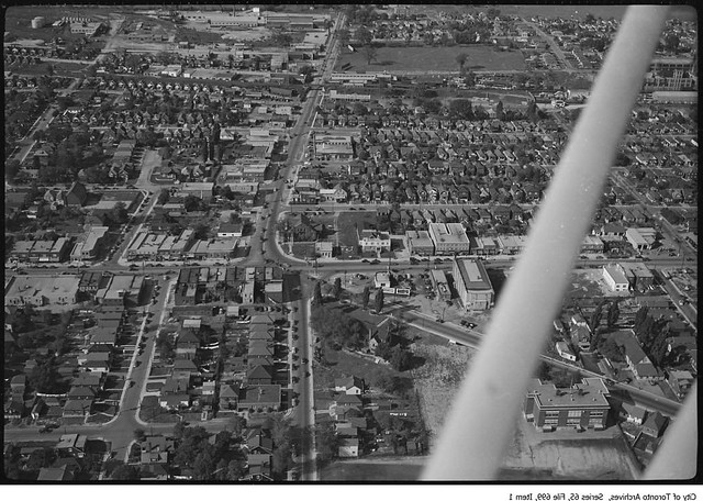
Dufferin looking north at Eglinton Avenue in 1949, Vaughan Road joins on the right. Corrected from original Archives photo here. Credit: Toronto Archives (Fonds 220, Series 65, File 699)
North of Wilson Avenue, Dufferin Street used to continue all the way to Steeles and beyond into Vaughan Township. Downsview Airfield was one of many small country airports that surrounded Toronto, but grew when it was selected as the Canadian production facility for De Havilland Canada, producing general aviation and military aircraft since opening in 1929. As the airport expanded during the Second World War as the Royal Canadian Air Force established a base at Downsivew, one of the runways crossed Dufferin Street, with a traffic signal to control aircraft and road traffic, much like the road/runway crossing at Gibraltar. A photograph of this crossing was posted to the Vintage Toronto Facebook page last January.
Eventually traffic was diverted away from the airport lands via Wilson Heights Boulevard and later the William R. Allen Expressway (now known as Allen Road). North of Wilson Avenue, Dufferin Street morphs into a two lane road and ends at the De Havilland plant, now owned by Bombardier.
A section of Dufferin Street between Sheppard Avenue and Wilson Heights Boulevard was orphaned when through traffic north of Wilson towards Vaughan was diverted to Wilson Heights Boulevard around Downsview Airport and is still today a side street with houses on one side. The Allen Road extension, constructed in the 1980s from the Wilson Heights interchange across a disused runway, continues as Dufferin Street north of Steeprock Road/Wilson Heights.
The first permanent transit route on Dufferin Street was a short section of the Briar Hill bus, introduced in 1949. The route served several neighbourhoods north of Eglinton Avenue in York Township and Forest Hill. This service was part of the Township of York Railways operating agreement where the TTC operated streetcars and buses on behalf of York Township, collecting a separate fare.
With the creation of Metropolitan Toronto in 1954, the responsibility for public transit was transferred to the new upper-tier government (making the redundant the Township of York Railways) and the TTC expanded into Etobicoke, Scarborough and North York. That year the Briar Hill route was replaced by a new Dufferin Busfrom Eglinton in the south, connecting with the Eglinton West bus and Oakwood streetcar, to Wilson Avenue in North York. Some trips were extended to serve the De Havilland aircraft plant. Still, there was no regular transit service on Dufferin south of Eglinton. The Dufferin bus route was later assigned the number 29.
In 1955, the old Dufferin Park racetrack closed, as part of a trend of consolidating horseracing to larger facilities such as “Old” Woodbine (later Greenwood) Racetrack on Queen Street East and a planned “New” Woodbine to be built in Rexdale. The track was demolished and replaced a year later by a large strip mall, Dufferin Plaza, featuring a Loblaws supermarket as the anchor tenant. Unusual for central Toronto at the time, the new plaza offered shoppers ample free parking; the closest transit services in 1956 were the streetcars on Bloor and College Streets.
Another route restructuring in 1960 saw the Oakwood streetcar abandoned and replaced with an extension of the 63 Ossington trolley coach. In 1961, a new limited service bus route, 73 Dufferin South, was introduced by the TTC. This route, which ran during rush and shopping hours (Monday through Saturday between 6:00 AM and 6:00 PM, until 9:30 PM Thursdays and Fridays) between St. Clair Avenue and Queen Street. Dufferin Plaza itself welcomed the new bus service, and ran ads such as the one below, even offering a free token to shoppers for return fare home.
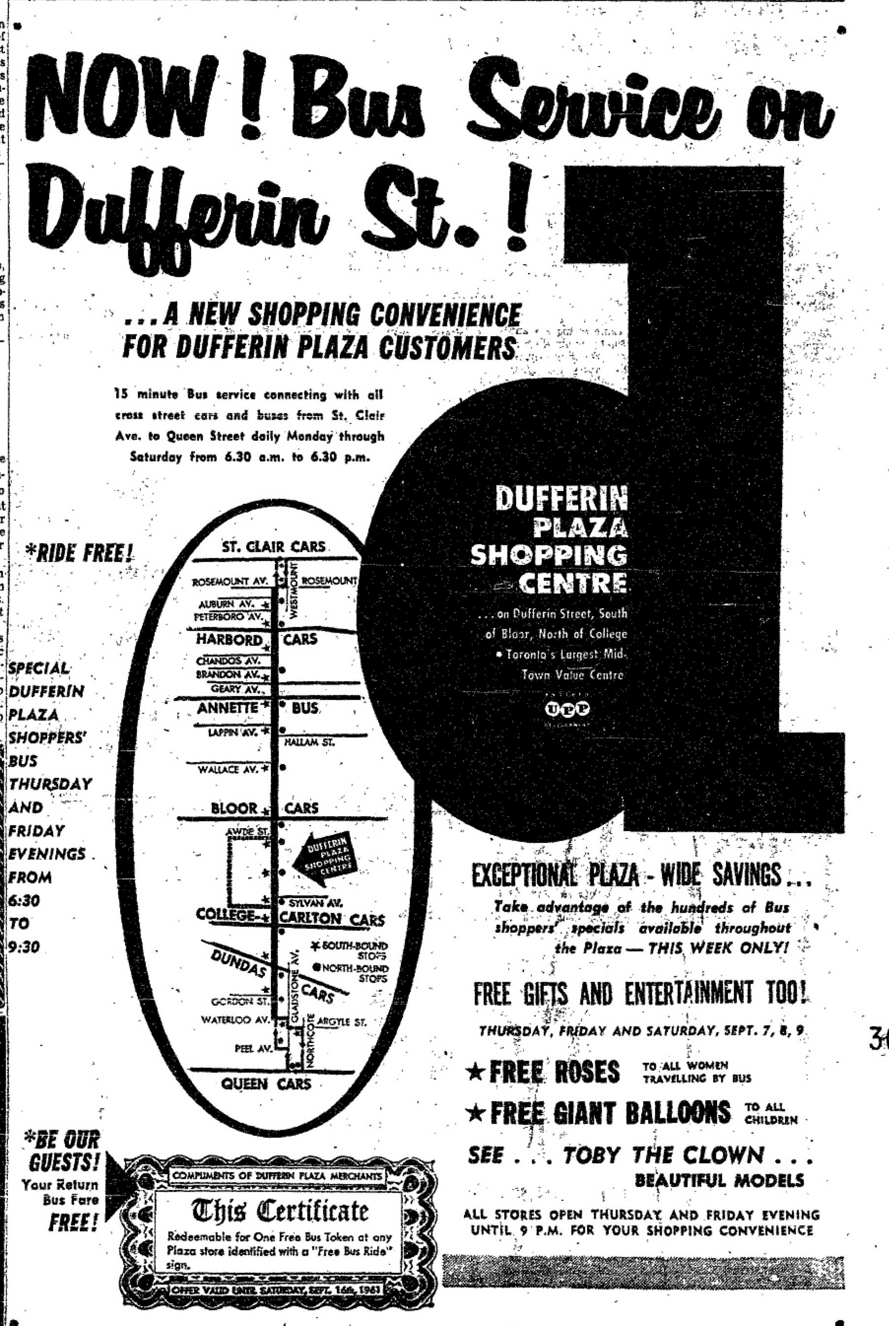
Dufferin Plaza advertisement published in the Toronto Star, 1961. Image via and courtesy of Transit Toronto.
A year later, in 1962, the 29 Dufferin Bus was extended south, incorporating the 73 Dufferin South route and finally provided a through transit service on Dufferin, filling the gap between Eglinton and St. Clair. Still, the 29 Dufferin was a relatively minor route compared to the 47 Lansdowne and 63 Ossington trolley coach routes to the west and east respectively. When the first phase of the Bloor-Danforth subway line was opened in 1966, the station at Dufferin Street was simple, without a off-street transfer facility such as at Ossington.
In 1964, Yorkdale Plaza opened, Toronto’s first super-regional mall. The new indoor shopping centre was anchored by Simpson’s and Eaton’s and helped to change travel patterns on Dufferin. Even before the mall was completed, an underpass was built at Dufferin to allow shoppers to drive in and out of the parking lot without having to make left turns. Before the Allen Road “turbochange” opened (coincident with Yorkdale’s opening) and Highway 401 widened from four to twelve lanes in the late 1960s, the 401/Dufferin interchange allowed all traffic movements to and from the highway.

Dufferin Street looking south from Highway 401, 1960. Bridgeland Road and access to 401 eastbound is on the right. Credit: Toronto Archives
Today the 29 Dufferin is one of the TTC’s busiest surface routes, and is in fact, the busiest north-south bus route with 39,700 boardings in 2012. The older, busier routes such as 63 Ossington and 47 Lansdowne declined in importance as large industries in the west end such as Massey-Ferguson, Inglis, and General Electric closed; both routes were dieselized in 1991 with the phase-out of Toronto’s trolley bus network and service reduced. The expansion and enclosure of Dufferin Mall in the 1970s (including a new anchor, Woolco) and Yorkdale’s expansions made both malls even more important trip generators contributing to the route’s importance.
Besides the shopping centres, Dufferin Street connects many interesting and diverse neighbourhoods from Downsview to the north to Parkdale to the south. Dufferin Grove Park, across from recently renovated Dufferin Mall, is one of the city’s most interesting local community spaces. New condominiums under construction at Dufferin and Lawrence are the first of several proposals for the northern half of the street; the new Crosstown LRT station at Eglinton and Dufferin will likely promote changes to that part of the corridor as well. The largely vacant Galleria Mall at Dupont, now without anchor tenant Zellers, is one of several other potential development sites on the street. Dufferin Street’s history is still in the making.
5 comments
The June, 1948 photo of Dufferin Street looking north from College, shows two interesting points. One, the trees on the right of the photo shows them pruned, ready to be cut down for the widening. Two, no traffic lights at Dufferin and College. Who needs them, they’ll only slow the streetcar service down on the crossroads.
The 1949 photo of Dufferin looking north to Shanly Street, shows how much lawn would be sacrificed to appease the automobile gods.
I seem to recall from childhood trips to Yorkdale that Vaughan still “met” the Dufferin-Eglinton intersection in the 60s and maybe even into the 70s–whether there was a special traffic light arrangement or something more “casual” a la Scollard relative to Yonge-Davenport, I don’t know…
Great article, Sean!
What’s always intrigued me is how far north the names extend. Bathurst Street sort of intersects with Yonge when old Highway 11 takes that turn towards Bradford, and Dufferin goes nearly that far north. You can also see Keele Street and a Keele Lane, I think, as the line road is broken up by natural features. Were they named at the same time as the lower ends of those roads, or did that come later? I always think it’s funny coming upon these roads so far north and thinking how different they are from where they were nearer the lake.
In 2010, the Dufferin Street underpass was created under the railway, to allow Dufferin Street to bypass the jog along Queen, Gladstone, and Peel. During the construction, they laid a concrete foundation in the center lanes, which could be suitable to allow for future streetcar tracks.
Currently, the City of Toronto is doing watermain replacemement and combined sewer replacement on Dufferin Street, north of Peel (Queen Street West) and Dundas Street West. After that word, they could lay a suitable concrete foundation in the center lanes between Peel and Dundas for future streetcar track expansion.
WK Lis: I wouldn’t advocate streetcar service on Dufferin Street as there’s no room for a right-of-way for much of the length and there’s a lot of through travel at Bloor Street that would be inconvenienced by a streetcar service south of Bloor or even say St. Clair (plus you’d have to find room for a loop). However, new tracks between Queen and Dundas or College could be useful for diversions and special event services, such as the old 522 Dundas-Exhibition car that will be making a comeback this year.