

One of the more intriguing elements of the West Don Lands development was the promise that it would include some “woonerfs“ — a Dutch concept generally translated as “living street” though more literally (according to Wikipedia), “living yard.”
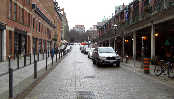
The first one, Trolley Lane, has now been partially built, and has already been touted as Toronto’s first woonerf. It’s a U-shaped route just south of King St. East, intersecting twice with Lower River Street (the joining part is not yet complete).
I recently went to check out this promising new feature, but it was rather disappointing. While Trolley Lane is nicely designed, it’s not really a woonerf. There’s no fixed definition of a woonerf, but it seems fair to say that, if we are using the Dutch word, it should somewhat resemble what the Dutch do. In essence, a woonerf is intended to be a front yard for the residents who live on it. Cars should be rare, local, and restricted to walking speed. Often the street is configured to be narrow and a bit awkward so that cars have to be careful manoeuvring in it. Parked cars are sometimes arranged to deliberately contribute to this awkwardness. There are no sidewalk curbs restricting pedestrians to the side of the street, and signage indicates that pedestrians have priority and playing children should be expected.
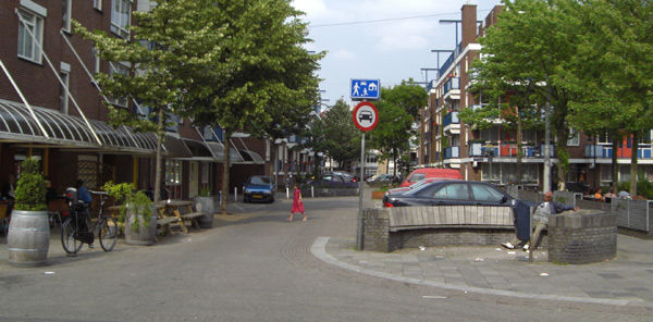
Here is a photo of a Dutch woonerf:
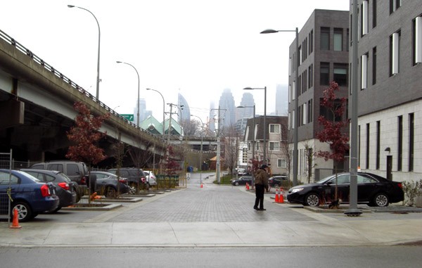
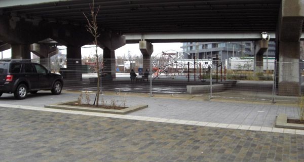
The southern portion of Trolley Lane, by contrast, is in fact primarily a space for cars: a rear lane, a parking lot, and the access point to an underground garage. No housing faces onto it, and there is no signage indicating pedestrian priority. The space is nice and wide, making it easy for cars to manoeuvre, and parking is kept neatly to the sides, rather than being used as an obstacle that narrows the street and calms traffic.
[Update: Waterfront Toronto has indicated that “bike rings and other street furniture fixtures” will be installed where the cars are currently parked, preventing cars from parking in those locations. See comment below for my further comments on their blog post.]
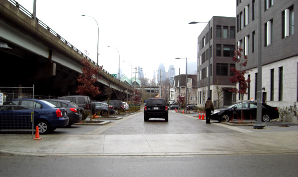
It will likely get plenty of vehicle traffic, as its primary purpose is access to a parking garage for a pair of buildings.
While pedestrians might occasionally use it as a shortcut, it’s hard to imagine children playing here. The space is considered dangerous enough that the Underpass Park playground beside it is currently fenced off. It’s not clear what will happen in the future, although some separation will be necessary to keep cars from driving into the park. My guess is a more permanent fence will eventually be installed to keep children from running onto the lane, given the heavy presence of vehicles.
[Update: the bike rings and other street furniture fixtures to be installed in the gaps between the trees will provide the separation I expected to keep cars from driving into the park. There are no plans for a fence to keep children from moving through this space]
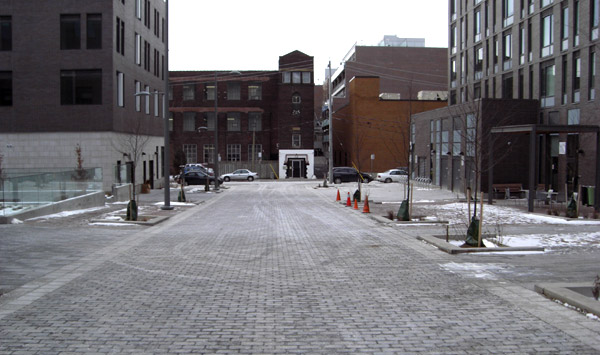
The northern branch of Trolley Lane is, at least, not a parking access road. But it is still a back lane, existing primarily for loading and garbage pickup. While there are rear entrances that open onto it, there’s little indication it should serve as a “yard” for the apartment buildings on either side. The courtyard on the south side (left, below) is clearly separated from it. On the north side, there’s a little patio by a back entrance, but it’s quite separated from the laneway itself. Nothing indicates or invites pedestrian priority in the roadway.
The “U” part to the east is still being developed, but it looks little different.
Don’t get me wrong — I like these lanes. As back lanes go, these are very nice ones, and good for Waterfront Toronto for putting an effort into them. They do share with woonerfs some basic “shared street” characteristics: they don’t have curbs, and they are paved in a nice material. But those characteristics are true of many streets — they do not make it a woonerf. To call it that is to promise way more than these streets deliver. What’s worse, it could leave people unimpressed with the whole concept and not interested in pursuing pedestrian priority streets in other locations.
Ironically, a street just one block west of Trolley Lane is a lot more like a woonerf. Percy St. is an unassumed (i.e. private) street in Corktown. The little street, paved in brick, with houses facing on it and parked cars narrowing the way, is quite a good example of a street as a “living yard.”
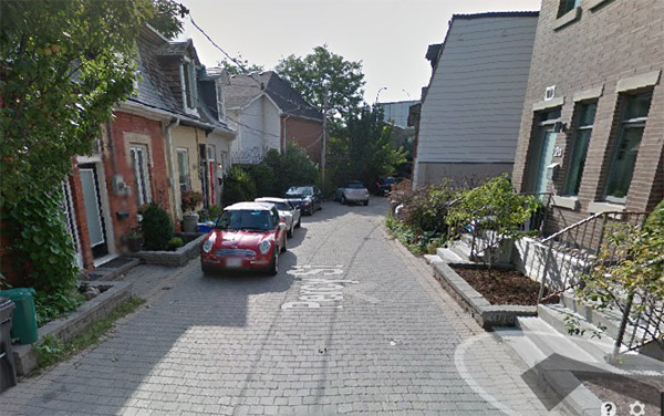 Google Street View
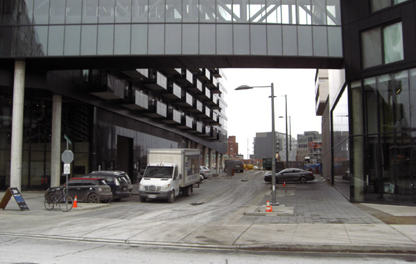
An interesting example of another new “shared” street in Toronto, which likewise has no curbs and nice paving, is the revamped Market St. on the west side of St. Lawrence Market.
On the west (above left) side, the space between the bollards will be used for restaurant patios for 8 months of the year, and parking during the 4 winter months. The permanent parking on the east side, meanwhile, makes the street narrow enough to slow traffic. No-one has claimed this is a woonerf, as far as I know, although since the driving space is more constrained and it actually has main entrances on it, it might be closer to one than Trolley Lane.
It may actually be impossible to introduce a true woonerf in Toronto on a public street. Ontario regulations specify that all new roads, even laneways, have to have 6 metres of unobstructed width for fire trucks, and fire departments generally insist on a straight line for speed. It’s hard to give a street a cozy, safe “living yard” feel with that much straight open space. Perhaps it could be possible on older, grandfathered narrow streets like in Kensington Market, or dead-end streets.
Even if we can’t get a full woonerf, though, it’s good to see that that Toronto is finally experimenting with interesting new street concepts and designs. As a city, we should continue to look for ways to reinvent and redesign our streets whenever possible. But let’s not, in our enthusiasm, oversell them and pretend they are something they are not, if only because then we won’t realize there is still something even better to strive for.
Photos by Dylan Reid unless otherwise indicated
10 comments
Laney’s Mill along False Creek has beautiful pourous brick that allows grass to grow and emergency & service vehicle access. Climate helps but that’s what I picture when I hear of “woonerfs.”
If it’s still too easy to barrel through it in a straight line in a car, it’s not a woonerf. Ideally there should be some homes that do not front directly onto the road and scattered parking spaces to break up the straight lines. Something like this:
http://goo.gl/maps/t2ESN
Market Street has the potential to be a winkelstraat (shopping street) if motor vehicle traffic is restricted and parking is either dispersed or removed entirely.
I’m surprised fire trucks somehow need 6m, given they fit down a standard road lane (3.7m wide).
@Tom West
I read somewhere a while back that the idea of a 6 m width is that there is sufficient room (i.e. 1.5 m) for firefighters to work on either side of a firetruck (3.0 m max width) parked in the middle of the lane.
I had come to the same conclusion as the author that true new-build woonerfs are basically impossible in Ontario and possibly Canada due to fire route rules, since not only is a large minimum width specified but also that entire width must be clear of parked cars or other obstructions. Having a 6.0 m clear width for some length of road (say 15* m) every, say, 30* m and never less than 3,75 m wide between these clear areas just isn’t enough under existing rules, even though that kind of layout would likely allow for woonerfs of a sort.
*those numbers aren’t entirely arbitrary on my part: they add up to 45 m, which is the rule for fire hydrant spacing.
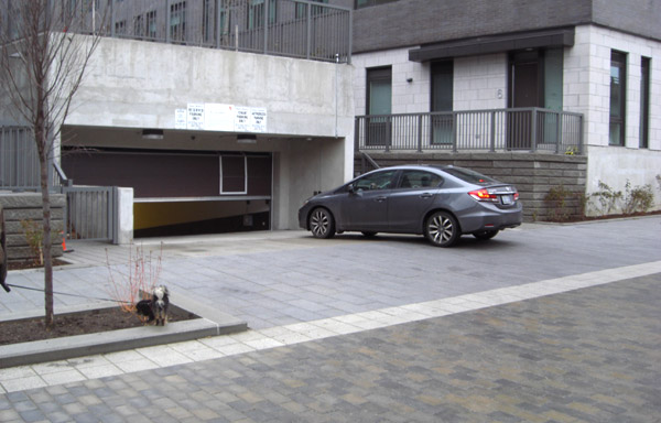
I live in the middle of this and have a couple of observations. Firstly, all of the parking you note – particularly in the second image and and sixth images) is illegal – there are No Parking signs, and on occasion drivers have been ticketed. However, with ongoing construction the city seems less inclined to properly patrol and flag these vehicles. The only legal street parking that I can see is on the East side of River St, immediately adjacent to the property at 47 Lower River Street. This is actually a bit of a tricky situation, as most buildings have at least some kind of designated lay-by for loading / offloading, deliveries, etc. Those that make up the River City complex, do not.
Secondly, the fencing separating the area from Underpass Park is not meant to protect the park’s users, but to keep them out of the recently active construction site. As recently as November, right before the TCHC buildings were occupied, there was an onsite security guard barring pedestrians from walking across the section of Trolley that you illustrate in picture five, even though it was in a similarly finished condition.
But thank you for pointing out one of the (so-far) more disappointing aspects of the area’s redevelopment – meant to be living, these streets are very sterile. Hopefully come Spring we’ll at least get some benches.
For
The street I live on could be considered a woonerf. It runs east/west between Sackville Street and Rawlings Ave. The west half is single lane two way traffic; the east half is two lanes. Very few cars and most pedestrians treat the entire street as a place for pedestrians to stroll, both on the sidewalk and on the street.
I read the article, and I keep hearing from an early Simpsons episode (I assume the scene is a spoof of the Harrison Ford movie Witness) “Ay, ’tis a nice barn… but to be sure ’tis no pool English” “D’oh”
The irony in your photo is that kids are left to play under the roadway while cars get to park out in the light of day.
Don’t get me wrong, the underpass park is really nice, but they could have just as well put a parking garage under it and freed up some more green space for the community.
Waterfront Toronto has replied to this post, providing information about additional features to be installed and explaining their reasoning in describing this space as a woonerf: http://ow.ly/IXrcn
Before I analyze their reply, let me reiterate that I like these spaces and appreciate Waterfront Toronto’s efforts in making them appealing. I just don’t think they can be accurately described as woonerfs.
Waterfront Toronto indicates one substantive upcoming change: the places where cars are parked on the laneway in the photo above will be blocked off by bike rings and other street furniture. This will certainly be an improvement, and reduce the presence of vehicles in this space (I have noted this update in the text above).
However, it does not change the question of whether it’s appropriate to describe these as woonerfs. The following characteristics of woonerfs still will not be present:
– No buildings front onto these laneways (though there are back entrances)
– There are no awkward spaces to control vehicle movement
– There is no formal indication of pedestrian priority
These streets might be more accurately described as inspired by the concept of “Naked Streets”, in which curbs and signage are removed from a street to disorient users and encourage slow and careful shared use. These are also Dutch, but they are different from a woonerf, which is normally formally designated as a pedestrian-priority street and is deliberately awkward for drivers (see this article in the Daily Telegraph, which Waterfront Toronto brought to my attention: http://www.telegraph.co.uk/motoring/road-safety/9086705/Why-woonerfs-will-change-how-we-drive.html).
A few other points from the WT blog post.
– They seem to agree with me that fire regulations requiring minimum clear street width effectively prevent the creation of a true Dutch-style woonerf in Ontario, at least for new, public streets. We just disagree on whether the resulting street should still be described as a woonerf.
– They suggest that a reason Market Street isn’t a woonerf is the presence of bollards, which Trolley Lane doesn’t have. However, this is an academic distinction. On Trolley Lane, the trees and the future street furniture are performing the same function as the bollards — keeping vehicles from travelling into the edges of the street reserved for pedestrians. As we can see above, these are necessary because otherwise vehicles will park there — the same situation as on Market Street.
– I hope that Waterfront Toronto is correct and that pedestrians and cyclists will feel comfortable using these spaces. However, I’m not convinced people will linger there or children will play there (as described in the Wikipedia definition quoted in the WT blog post). As noted earlier, the buildings don’t front on this lane, so there’s not all that much reason for pedestrians to be there. As well, there’s no indication that city regulations prohibiting playing on streets have been suspended in this area. Like I said, these are nice laneways, and people in Toronto already use laneways as shared spaces (and kids sometimes play in them), so perhaps they will be used this way, but it seems like that would be informal usage, not legalized usage as in a woonerf.
– a minor issue, but at one point, Waterfront Toronto tweeted that woonerfs don’t allow heavy trucks. When I pointed out that Trolley Lane is in part designed for garbage and delivery trucks, they said they would address that point, but they don’t really (https://twitter.com/dylan_reid/status/562732947061899265). I don’t really think this is a big deal, but I think it’s an example of how the term is being used rather loosely.
So, while I am encouraged that further amenities will be added to these attractive lanes, calling them a woonerf is still a stretch. Better to call simply call them shared streets.
We appreciate this discussion, Dylan. We’re all eager to see how Trolley Crescent will work as a shared space.