
There’s a couple of new lofts at the southeast corner of Carlaw and Dundas. The courtyard between the two buildings curves elegantly south until it’s almost parallel with Boston Ave., a north-south residential street.
It’s a neat design feature that gives both structures a nice irregular shape, but what’s not immediately obvious is that the curved space reflects the path of a long-closed rail spur that used to serve the former Wrigley chewing gum plant and other factories in the area.
At the southwest corner of the intersection, the entrance to Dundas & Carlaw, a cafe and bar, is at a strange angle for the same reason. An industrial building on Thackeray St., north of Dundas, likewise has rounded edges on two of its corners to accommodate trains that vanished in the 1990s.
The effect on the architecture of the area is most apparent from the air.
Evidence of Toronto’s atrophied industrial rail network is everywhere, if you know where to look. A few blocks away, down the back of the Jimmie Simpson Recreation Centre in Leslieville, pieces of another defunct siding are hidden among the trees.
Peek over the forbidding metal fence between the centre and the rail corridor and you’ll see a concrete buffer and an old metal sign still bolted in place from a time when freight trains would stop there.
In fact, the recreation centre is built on top of Suburban Place, a little residential street that used to run parallel to the former rail siding. From the 1890s to some time after 1913, there were seven homes on the street, which used to exit onto Queen.
Were the houses still standing today, all would be inside the Jimmie Simpson centre.
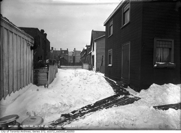
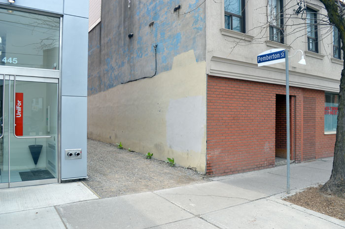
In Corktown, there’s a street similar to Suburban Place that’s still clinging to existence. Pemberton Street runs south off King near Trinity Street. It’s got an official City of Toronto marker at its entrance, although there’s little else to differentiate it from a gravel driveway or a parking lot for the office building next door.
Like Suburban Place, Pemberton used to have houses. A 1913 plan of the city made for fire insurance purposes shows a terrace of six homes on the west side of the street. All are gone now, and now a trip down Pemberton is as short as it is eventful. Two houses on Trinity have backyards that open onto the unpaved strip and, that’s about it.
Elsewhere in Toronto, vanished parts of the cityscape are making a comeback. On Church at Wellesley, streetcar tracks buried for more than five decades are rising from beneath the road surface.
In the 1960s and 1970s, when it was TTC policy to abandon streetcars in favour of subways, the city paved over kilometres of disused surface track, including much of what used to form the Church line.
At its zenith, the Church streetcar headed downtown from Dupont and Christie via Dupont, Avenue, Bloor, and Church to Front. According to Transit Toronto, an authority on all matters related to the history of the TTC, service on Church came to an abrupt end when the power hungry Yonge line started to trigger brownouts in the downtown core.
To save power, the TTC switched the Church line to diesel buses in the 1950s. Eventually, the temporary measure became permanent, and now the remaining Church tracks south of Carlton are only used during diversions or short turns.
When the tarmac softens under the hot summer sun, the buried Church rails sometimes warp and break the surface—proof that no transit line in Toronto is ever truly dead.
Evidence of other defunct streetcar lines is even more subtle than ghost rails. Walk (or Google Street View) down Pape from the Danforth, turn west on Riverdale Ave., then south down Carlaw and take note of how many former store fronts have been turned into living rooms.
Part of the reason for this was the cessation of the Harbord streetcar in 1966.
The Harbord service used to snake from Davenport and Lansdowne through the core via Spadina and Dundas to a loop just north of present day Pape station.
In the east end, it travelled along Carlaw, Riverdale, and Pape. When the Harbord line got the chop in the years after the opening of the Bloor-Danforth line, many of the stores closed and became extensions of the apartments above.
My absolute favourite piece of disused Toronto infrastructure, however, is the Eastern Ave. bridge over the Don River. Built in the 1930s, the metal truss used to carry vehicular traffic until the 1960s, when the Don Valley Parkway cut off its eastern connection.
In the 1990s, when the West Don Lands was cleared to make way for ill-fated Ataratiri neighbourhood, the bridge lost its western connection and became completely marooned.
Today, it’s only accessible from the Don Valley recreation trail through a hole cut in a chain link fence. On one end, roaring traffic. On the other, the whir of bicycles and thump of occasional joggers.
The city has found a way to move around the bridge without ever touching it.
Like this? More Toronto quirks and curiosities here.
10 comments
Probably a bunch of similar abandonments in the suburbs. The abandoned on-ramp at York Mills Road and the DVP comes to mind.
https://www.google.ca/maps/place/York+Mills+Rd+%26+Don+Valley+Pkwy,+North+York,+ON+M3A/@43.7586317,-79.3359956,481m/data=!3m1!1e3!4m2!3m1!1s0x89d4d27d6ebf741f:0xf3f1fb357bd08296?hl=en
Great article! FYI, the Church Streetcar line wasn’t shut to “save power” in the 1950s. It was rendered redundant by the construction of the Yonge Subway one block to the West – there simply was no longer traffic to support a high-frequency streetcar line on Church.
On Sudbury Street from Dovercourt road to Lisgar street(south of Queen Street West) is a piece of unused railway track still in full exposure.
It was once a spur line that went from the tracks that now houses the Union Pearson Express to the Don Glass Works that has now been built up with new housing.
218 Ryding Avenue/2307 St. Clair Ave W in the Stockyards is another recent example. A single rail line used to run through the park, between homes & businesses and into the Stockyards. I believe it was used up until some point in the 1990s. Google Street View shows the rails intact in 2007, in 2009 it shows the rails removed from new & expanded private property, then in 2011 removed from public spaces as well.
Agreed: wonderful article full of fascinating anecdotes.
To Raymond: the article is correct: the CHURCH streetcar was shut down due to brownouts caused by the Yonge subway — or, at least, that’s the TTC’s excuse. Certainly, the opening of the Yonge subway probably reduced ridership, but it survived the opening of the Yonge subway by two months. When the subway opened in March 30, 1954, it caused several streetcar routes to fall, including YONGE, BAY, several trippers, and so on, but CHURCH kept running. If the abandonment was directly linked to the subway, it should have come on March 30, 1954, not on May 15 or so, as was the case.
I love urban archeology like this. Keep em coming!
The random bit of streetcar track somehow still surviving on Strathmore Boulevard, abruptly ending at Cedarvale, from back when the Danforth streetcar served Woodbine Station: https://www.google.ca/maps/@43.687164,-79.315515,17z?force=lite
On a Jane’s Walk I heard that the gap between the new buildings at Carlaw+Gerrard was because the owner of the railway right-of-way wouldn’t sell to the owner of the properties on either side. I’m kind of glad, because as you say the resulting buildings are more interesting than usual.
Also, some of the old storefronts on Pape have survived as businesses, and even occasionally are being restored as new businesses.
The original industrial use of what’s now know as Liberty Village had major rail infrastructure, and some of it can still be seen today. Spur lines used to run north from the main line at almost every street.
In fact one building I worked in used to have an old rail car marooned in it’s back loading dock.
still a lot of rail infrastructure to be found in the junction triangle, too.
e.g. the alley behind the sterling studios just south of bloor off merchant lane. lengthy spans of track run north-south (from the current home of cirque-ability, 213 sterling, the door to which seems high enough that it may have been able to house a railcar for unloading or repair, etc.)