
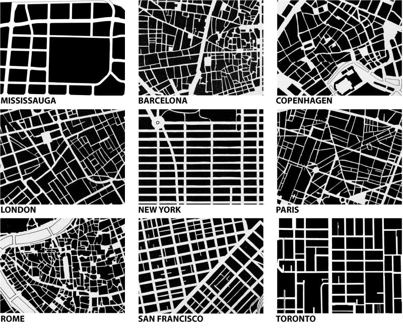
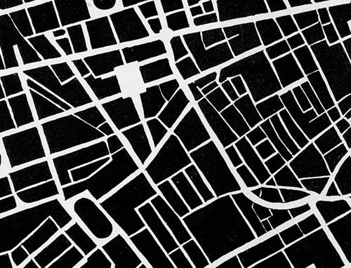
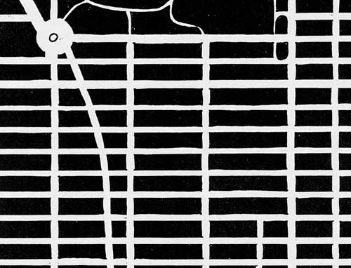
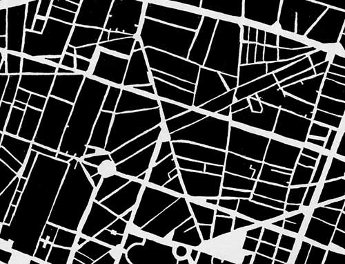
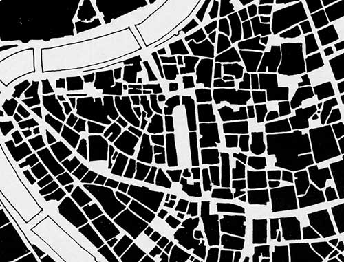
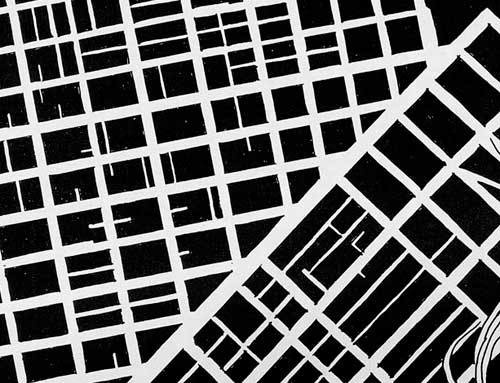
The Star today published a cover story (Beyond Density) in their Condos section on the efforts in Mississauga to create a more vibrant and pedestrian-friendly downtown – key among the problems identified has been the large scale of the block patterns in Mississauga – to prove the point the article includes urban form/fabric drawings of 9 cities (one hopes at the same scales) in order to compare the scales of the fabric of the street network. I include the drawings below alphabetically (with Mississauga first).
(edit: a friend requested I lay out all the drawings in a grid for easier comparison – I hope you enjoy – click on the above image for a larger version)
More than anything, the comparisons expose the inherent problems of scale in trying to evolve any suburban, auto-oriented area into a more pedestrian-oriented centre. The traditional response in suburbia has been to internalize pedestrian areas (in the form of the mall), Square One (home to the largest Walmart in the world) being a particularly powerful example, though Scarborough Town Centre might be the more classic one. The size of Square One’s block makes a very interesting comparison with Copenhagen’s city centre (2nd below) in which a series of streets and spaces have been linked together and pedestrianized (view a map of the pedestrian areas of Copenhagen from Metropolis magazine). In size or length of pedestrian space, the two might even be close, but in overall character and degree of integration into the urban fabric (particularly important for pedestrians) they are from wholly different worlds and you can easily trace much of these differences to the scale of the street fabric.
The other striking lesson from such comparisons is that there really is no perfect form of street fabric – many different networks and patterns are capable of producing wonderful places and being friendly for pedestrians as long as their fabric allows frequent and comprehensive linkages – there simply seems to be an upper scale beyond which all hope of efficient (and therefore popular) pedestrian circulation is gone.
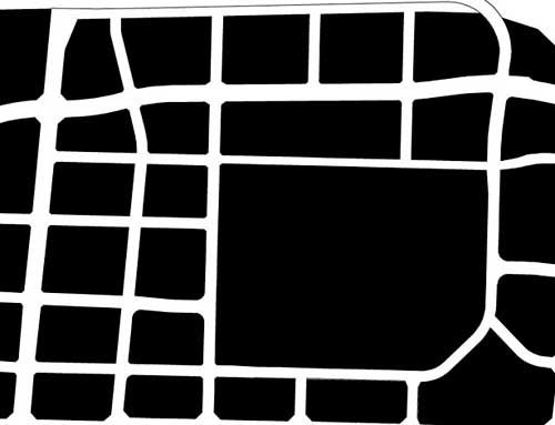 MISSISSAUGA: “Long blocks and virtually empty sidewalks”
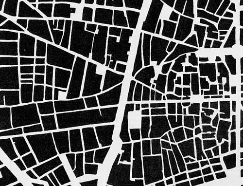 BARCELONA: “La Ramblas is the main north-south promenade”
 COPENHAGEN: “City features a car-free zone called the Stroget”
 LONDON: “The Mayfair and Soho districts south of Oxford St”
 NEW YORK: “Midtown Manhattan south of Central Park”
 PARIS: “Streets were designed by Georges-Eugne Haussmann”
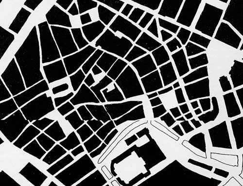
 ROME: “East of the Tiber River bend that points to the Vatican”
 SAN FRANCISCO: “Market St splits the central city into two grids”
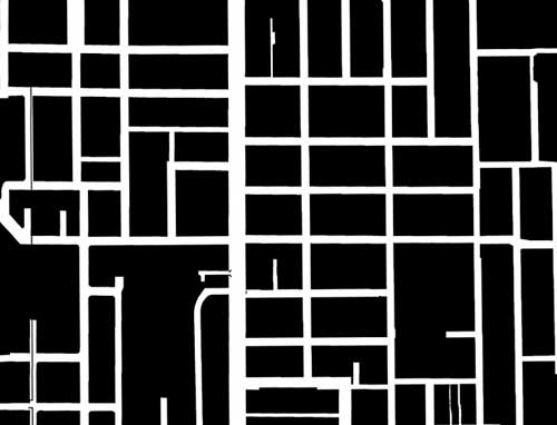 TORONTO: “Between Queen and College Sts east of Bathurst”
Crossposted to bricoleurbanism.org


19 comments
Something that is not addressed in discussion of ‘New Urbanism’ is that it is not only the quality of pedestrian space that pedestrianizes a space, but also the percentage of adults who do not own cars.
Apart from other factors, the area around Square One will never have as vibrant a streetscape as those parts of Toronto well serviced by the TTC in the old city, because nearly every adult in Mississauga feels a need to own a car. In the unlikely event they can comfortably live in their area without a car, it is less likely they can easily get to gainful employment, much less pursue a rich social life. Once most adults have that car, there is little keeping them in the area to populate its sidewalks. ‘New Urbanism’ is a poorly thought fantasy: there is a reason that succesful urbanism is confined to pre-war neighbourhoods.
When I see these maps, I can’t help but think of ants digging there way through dirt. The older the city, the more delicate the maps become. Hopefully Missisauga and Toronto will be able to fill in there empty frames.
On second thought, there is a way to make ‘New Urbanism’ successful: massive (and I mean a minimum of downtown Toronto standards) upgrades to mass-transit, needing three levels of government with vision and unbeholden to car and oil lobbies…
I don’t think I will get drawn away from the city in the forty years I have left.
Aidan, I think your points are valid, but statistically if you look at car ownership rates in Europe, they are consistently high – I believe between 400-600 vehicles per 1000 population, and often compares similarly with ownership rates in North America (at least for inner cities like Toronto, maybe not so for real suburbia). The key difference seems to be access to very good and comprehensive transit systems (even at the regional level), coupled with high gas prices, expensive or non-existent parking at workplaces and bad traffic congestion, which all together lead most Europeans (at least in the historic cores of cities) to leave their cars at home… not to mention of course, the wonderful pedestrian environments they usually enjoy when using alternative transportation…
“One will never have as vibrant a streetscape as those parts of Toronto well serviced by the TTC in the old city, because nearly every adult in Mississauga feels a need to own a car.”
And judging by all the condos going up in Toronto with plentiful(bylaw-mandated?) underground parking, Toronto will likely start going the other way.
Daemon: That parking is bylaw mandated and costs a small fortune for developers to put in ($30K / underground spot). This is a cost they never recover. Developers would *love* not to be forced into providing as many parking spots, but this would require some forsight on behalf of the city.
Daemon, my main point is that there are more adults in the old city without cars than there ever will be outside of it. Part of that is transit, part congestion, some of it is poverty, but much of it is density. The suburbs do not have the transit or the density, are starting to get the congestion, and the poverty is hidden: their working poor still often feel a need to own cars.
The point of the suburbs, and it’s fundamental failure, is not to live among people of a lower class than your own: the suburbs are an abnegation of social responsibilty. It is no accident that the 905 is blue.
If the goal was to highlight the most vibrant parts of the cities referenced, I question the selection of 48th-60th St in midtown to represent New York. This is an area that is almost entirely commercial, has few residents, and frankly is not as vibrant as some other districts. (Visit in the evenings or weekends and you will see my point.) The street grid slice from, say, Canal to W8th St would be a better representation, and it is also much more irregular.
The famed Manhattan grid is fun to include in any study, but the most interesting and pedestrian-friendly parts of the city are where the grid is interrupted or crossed or meshed with older pre-grid parts of the city.
The silhouettes in the Toronto Star article appear to be taken straight from the classic Allan Jacobs book “Great Streets”. Shouldn’t appropriate credit for the images be given? The Toronto Star didn’t create them! …(except perhaps the Mississauga one!)
I’m not sure if the paper copy gives credit, but the online version of the Star doesn’t seem to.
Dave, they are certainly from Allan Jacobs’ “Great Streets” – however, if you look at the original images online at the Star, you can see some marker lines from filling in black areas – a quick browse of “Great Streets” shows no such indication of drawing, the tones are perfectly black, so I suspect the Star has traced from “Great Streets” in which case it would be honourable to indicate the source, though if you’ve recreated the drawing by tracing, copyright probably gets questionable. The Star versions were also cropped slightly smaller (showing less area) than the originals in “Great Streets”. “Great Street” also has a wider variety of examples, including (I think) 2 each for different parts of San Fracisco and Manhattan…
It would also be illuminating to see a version showing built form and land coverage. Say, street rights-of-way are white like in the examples shown, but land with no structures is shown in grey, and only structures/buildings are shown in black.
Showing rights-of-way only, the Mississauga example almost looks half respectable, other than the big mass at the centre of Square One. Showing built form would tell an entirely different picture as it would highlight all the land used for parking lots.
(Of course, a few minutes on Google Earth would tell the same story.)
why did they take a view from the unplanned portion of barcelona, and planned views of all the other cities?
be consistent THE STAR. but as already indicated, you plagiarized your material. so i suppose the star is doubly wrong.
and FYI, these drawings are called ‘figure ground’ maps. they can also be used to compare built fabric to non built fabric. That would be interesting to see, since the STAR figure ground maps only show roads, not buildings. In Manhattan we’d see 100% build-out, while in Mississauga we’d see 20%.
Reminds me of Albert Pope’s book “Ladders”, comparing a grid of streets (urban) to a ladder-like system (suburban) in which, to get home, you progress along your route from bigger street to smaller to smaller, and there is really only one way to go.
I think this is a stimulating comment about density in cities.
The proble in North America is tne antiecological pattern of then cities. It will be very difficult to change the minds of society.
But it’s not the worst environment. You can see the other extreme of these question in the terrible slums of the Third World.
In Dharabi, Mumbay, there is 3 sqm per person.
I wrote about it this week at my blog
http://islasterritorio.blogspot.com/
I will come again
Cities are built with the main modes of transportation in mind. Older cities are more pedestrian friendly because modern transportation as we know it didn’t exist during the bulk of their growth.
New York is an excellent example of early solutions to modern transportation – the city experienced most of it’s growth just as cars were entering the scene. The blocks got longer, and more organized – more car friendly.
Mississauga is a modern example. It was built as a suburb to Toronto. One was meant to simply shelter there – and do the working and cultural living in the downtown areas of Toronto. Now they’re so large, they’re trying to break off as a city in their own right. Obviously, they’re encountering some problems with this new mentality.
If they plan well enough, as old buildings get torn down, they can shrink the sizes of the blocks and slowly reorganize the makeup of them. This will be a long process though and we wont be seeing results any time soon.
I think it’s more likely that the people will adjust the modes of transportation to make it easier to live in such environments. We’re over-due for a transportation evolutionary step, imo.
One thing to consider is Mississauga’s proximity to Toronto. It’s easy enough to drive to Toronto’s downtown, find a reasonable parking spot away from the core and take the transit system downtown.
Then there’s the traffic around Square One. Hurontario and Burnamthorpe are high traffic, multi-lane roads. I can’t see those roads being narrowed, streetcar tracks put in and parking meters all around to encourage more pedestrian flow. Mississauga might do better to zone a new area where businesses and residential areas are closer together.
Lastly, there’s Square One itself. It’s a big indoor shopping mall. Toronto’s downtown is arguably more vibrant because of the outdoor shops and attractions, away from the Toronto Eaton Centre — which tends to suck some of the life out of the immediate surrounding area. Consider Toronto’s Queen Street, for example.
James is correct – these figure-ground maps would be far more effective if they used black for actual built coverage and white for everything else (all open space). While they make instructive points regarding the structure of the street network, they tend to falsely imply that similar perimeter blocks built to nearly 100% ground coverage exist in both Mississauga and Copenhagen, which seems unlikely. The street grid is one (very important) part of the equation, but much more needs to fall into place to make density truly urban.
San Francisco’s city layout is the best! Market Street is the heart of SF. It’s got TWO subways underneath it, a historic streetcar line and a number of trolleybuses that run along the street.
Do you know of any books on figure ground studies?
Please email me if so. Thank you.